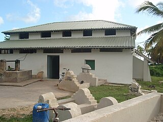
The Kizimkazi Mosque is a mosque situated on the southern tip of the island of Zanzibar in Tanzania and is one of the oldest Islamic buildings on the East African coast. Despite its name, it is located in Dimbani, not Kizimkazi, which is 3 miles away. According to a preserved kufic inscription, it was built in 1107 by settlers from Shiraz. Although the inscription and certain coral-carved decorative elements date from the period of construction, the majority of the present structure was rebuilt in the 18th century.
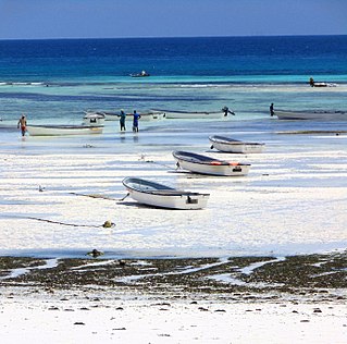
Kizimkazi - officially Kizimkazi Mkunguni, but also known as Kizimkazi Mtendeni - is a fishing village on the southern coast of Zanzibar, Tanzania, and was once a walled city. It is situated three miles southeast of the Kizimkazi Mosque. In recent years, Kizimkazi has become a major tourist attraction, as daily boat tours are organized to bring visitors off shore to watch bottlenose dolphins and swim with them.

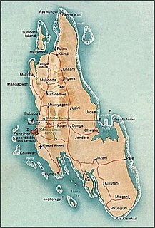
The Zanzibar Archipelago consists of several islands lying off the coast of East Africa south of the Somali sea. The archipelago is also known as the Spice Islands. There are four main islands, three primary islands with human populations, a fourth coral island that serves as an essential breeding ground for seabirds, plus a number of smaller islets that surround them and an isolated tiny islet.

Christianity is the largest religion in Tanzania representing 60% of the total population. There are also substantial Muslim and Animist minorities.
Tumbatu Island is the third-largest island making up the Zanzibar Archipelago, part of Tanzania in East Africa. The island is located off the north-west coast of Zanzibar's main island, also known as Unguja.

Mbweni is a town on the Tanzanian island of Unguja, the main island of Zanzibar. It is located on the central west coast, seven kilometres south of the Zanzibari capital of Stone Town.
Bububu is a town on the Tanzanian island of Unguja, the main island of Zanzibar. It is located on the central west coast, 10 kilometres north of the Zanzibari capital of Stone Town.
The Ras Mkumbuu Ruins are located on the west coast of the Tanzanian island of Pemba, part of the Zanzibar Archipelago specifically in South Pemba Region. They lie close to the village of Ndagoni at the end of a long narrow peninsula known as Ras Mkumbuu, which lies to the northwest of the town of Chake-Chake.
Jendele is a village on the Tanzanian island of Unguja, part of Zanzibar. It is located in the centre of the island, on the main route between Zanzibar City and Chwaka, to the north of the Jozani-Chwaka Bay National Park.

Jambiani is a group of villages on the Tanzanian island of Unguja, part of Zanzibar. It is located on the southeast coast between Paje and Makunduchi. Jambiani has a strong seaweed culture with many farms dotting the coastline and employing 15,000 locals, mainly women. Most seaweed that is farmed here is sold to the Zanea Seaweeds Ltd company and distributed around the globe. The Island of Zanzibar produces around 11,000 tons of seaweed each year, a large amount of this coming from Jambiani sources.

Fuoni is a village on the Tanzanian island of Unguja, part of Zanzibar. It is located five kilometres to the southeast of Zanzibar City, immediately to the east of the village of Mwana Kwerekwe.
Fumba is a village on the Tanzanian island of Unguja, part of Zanzibar. It is located in the southwest of the island, at the end of the Fumba Peninsula, and overlooks Menai Bay.
Jozani is a village on the Tanzanian island of Unguja. It is located in the southeast of the island, 3.1 miles south of Chwaka Bay, close to the edge of the Jozani-Chwaka Bay National Park. It is primarily a farming community of about 800 people. located 21.7 miles south-east of Zanzibar Town off the road leading to Paje, Zanzibar. It is easily reached by public buses 309 and 310, by chartered taxi or as an organized tour from Zanzibar Town. These tours are often in combination with dolphin observation in Kizimkazi, one of Zanzibar's oldest settlements with a tiny 12th century mosque open to public. The main road on the island, connecting the west and east coasts of Zanzibar, also connects to Jozani. Besides public bus routes 9, 10 and 13, you can also get here from Zanzibar Town by dala-dala number 309, 310, 324, and 326. Jozani is a small and rural village, situated in the innermost part of the Pete Inlet Bay, immediately south of the Jozani Chwaka Bay National Park. It is one of six rural villages surrounding the park. Residents here depend to a large degree on the Jozani Forest as a source of firewood, hunting, building resources, farming, fishing, and more. The village also operates ecotourism in the Jozani Forest and has constructed a 0.6 mile boardwalk through the mangroves at the southern road entrance into the national park. Many villagers work as authorized guides for tours in the southern tip of Jozani Forest.
Kae is not a village, but the beach of Michamvi village on the Tanzanian island of Unguja, part of Zanzibar. It is one of two villages located in the east of the island at the northern tip of Michamvi Peninsula. It lies on the shore of Chwaka Bay, immediately to the west of the village of Pingwe.
Pingwe is a village on the Tanzanian island of Unguja, which is part of Zanzibar. It is one of two villages located in the east of the island at the northern tip of Michamvi Peninsula. It lies immediately to the east of the village of Kae. In 2018, Pingwe Beach was named one of the world's best beaches in the "Special Ambience" category, according to Beach-Inspector.com. The beach's restaurant, called The Rock and situated on a massive rock only connected to the beach at low tide, has been called "painfully postcard-perfect."
Kibweni is a village on the Tanzanian island of Unguja, part of Zanzibar in the continent of Africa. It is located on the west coast, five kilometres to the north of the capital, Zanzibar City, on the road to Bububu and Chuini.
Kitogani is a village on the Tanzanian island of Unguja, part of Zanzibar in the continent of Africa. It is located in the southeast of the island, two kilometres south of Jozani.
Mahonda is a village on the Tanzanian island of Unguja, part of Zanzibar. It is located in the northeast of the island, seven kilometres to the west of Kinyasini and 20 kilometres northeast of the capital, Zanzibar City.

The Menai Bay Conservation Area (MBCA) is located in Menai Bay, Zanzibar Tanzania. At 470 square kilometres (180 sq mi), it is Zanzibar's largest marine protected area. It was officially established as a conservation area in August 1997 in the traditional fishing area, known as Unguja Island, covering the tropical marine environment comprising extensive coral reefs, tropical fish, sea grasses, and mangrove forests. In addition to controlling illegal fishing, MBCA's alternative initiatives have included bee keeping, mangrove replanting, tree nurseries and tourism. The management of the MBCA falls upon the Fisheries Department and the bay's local villages. It is rated by the IUCN as Category VI Managed Resource Protected Area.