The Dischma is a valley on the territory of the Swiss municipality of Davos. The name is derived from the Latin : decimus ("Tenth"). It is documented as decimata in the 12th century. [1]
The Dischma is a valley on the territory of the Swiss municipality of Davos. The name is derived from the Latin : decimus ("Tenth"). It is documented as decimata in the 12th century. [1]

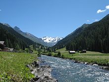
Dischma is the average of the three long, gently sloping, parallel alpine valleys stretching southeast from the Davos plateau toward the Engadin. Its north-eastern neighbour is the Flüela; its southwestern neighbour is the Sertig valley. The Dischma valley is drained by the Dischmabach. The valley floor is at an altitude of about 1500–2000 meters. The most important side valleys are the Rüedisch Tälli and Rinertälli.
In the valley, there are several small settlements and alpine pastures. Among the most important are, in order from the bottom to the top of the valley: In den Büelen, Wildi (1,577 m above the sea), Uf den Chaiseren (1,590 m above the sea), In den Stücken (1,616 m above the sea), Stillberg (1,974 m above the sea), Hof (1,664 m above the sea), Teufi (1,700 m above the sea), Boden (1,704 m above the sea), Gadmen (1,819 m above the sea), Am Rin (1,846 m above the sea), Grossalp (1,953 m above the sea) and Dürrboden (2,007 m above the sea).
These settlements form the Dischma neighborhood of the sub-municipality of Davos Platz.
At the end of the valley are the two passes leading into the Engadin: the Scaletta Pass (Romansh : Cuolm S-chaletta) and Fuorcla Grialetsch with the SAC's Grialetschhütte. This pass was important in the Late Middle Ages and the Early Modern Period for the import of wine from the Valtellina valley to Davos. At the top of the valley, we find the Scaletta Glacier between Piz Grialetsch (3,131 m above the sea) and Scalettahorn (3,068 m above the sea).
Important mountains on the Flüela side are Schwarzhorn (3,146 m above the sea), Piz Radönt (3,065 m above the sea), Sentischhorn (2,827 m above the sea) and Baslersch Chopf (2,629 m above the sea). Mountains on the Sertig side include Bocktenhorn (3,044 m above the sea), Jatzhorn (2,682 m above the sea) and the Jakobshorn (2,590 m above the sea), which is surrounded by ski lifts.
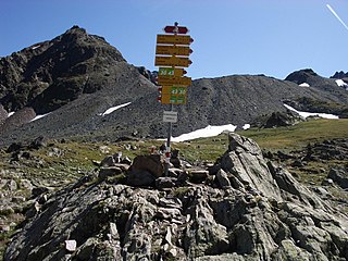
The Dischma and Sertig valleys are also starting points for a multi-day hike to the Piz Kesch, which is an ultra prominent peak, that is, a peak with a topographic prominence of over 1500 meters. The hike trail leads from the Dischma valley to the Keschhütte and around the mountain. [2]
Bus 13 of the Davos municipal transport company runs a regular service from Davos to Dürrboden.
46°46′33″N9°52′12″E / 46.77583°N 9.87000°E
| | This Graubünden location article is a stub. You can help Wikipedia by expanding it. |

The Albula Alps are a mountain range in the Alps of eastern Switzerland. They are considered to be part of the Central Eastern Alps, more specifically the Western Rhaetian Alps. They are named after the river Albula. According to AVE, the Albula Alps are separated from the Oberhalbstein Alps in the west by the Septimer Pass and the valley of the Sursés; from the Plessur Alps in the north-west by the Landwasser valley; from the Silvretta group in the north-east by the Flüela Pass; from the Sesvenna Alps in the east by the Inn valley (Engadine); from the Livigno Alps in the south-east by the Inn valley; from the Bernina Range in the south by the Maloja Pass and the Inn valley.

The Alpine region of Switzerland, conventionally referred to as the Swiss Alps, represents a major natural feature of the country and is, along with the Swiss Plateau and the Swiss portion of the Jura Mountains, one of its three main physiographic regions. The Swiss Alps extend over both the Western Alps and the Eastern Alps, encompassing an area sometimes called Central Alps. While the northern ranges from the Bernese Alps to the Appenzell Alps are entirely in Switzerland, the southern ranges from the Mont Blanc massif to the Bernina massif are shared with other countries such as France, Italy, Austria and Liechtenstein.

Davos is an Alpine resort town and municipality in the Prättigau/Davos Region in the canton of Graubünden, Switzerland. It has a permanent population of 10,832 (2020). Davos is located on the river Landwasser, in the Rhaetian Alps, between the Plessur and Albula Ranges.

The Grisons or Graubünden, more formally the Canton of the Grisons or the Canton of Graubünden, is one of the twenty-six cantons of Switzerland. It has eleven districts, and its capital is Chur. The German name of the canton, Graubünden, translates as the "Grey Leagues", referring to the canton's origin in three local alliances, the Three Leagues. The other native names also refer to the Grey League: Grischùn in Sutsilvan, Grischun in the other forms of Romansh, and Grigioni in Italian. Rhaetia is the Latin name for the area. The Alpine ibex is the canton's heraldic symbol.

The Engadin or Engadine is a long high Alpine valley region in the eastern Swiss Alps in the canton of Graubünden in southeasternmost Switzerland with about 25,000 inhabitants. It follows the route of the Inn from its headwaters at Maloja Pass in the southwest running roughly northeast until the Inn flows into Austria, little less than one hundred kilometers downstream. The En/Inn subsequently flows at Passau into the Danube, making it the only Swiss river to drain into the Black Sea. The Engadine is protected by high mountain ranges on all sides and is famous for its sunny climate, beautiful landscapes and outdoor activities.

The Silvretta Alps are a mountain range of the Central Eastern Alps shared by Tirol, Vorarlberg and Graubünden (Switzerland). The Austrian states of Tirol and Vorarlberg are connected by a pass road. The majority of the peaks are elevated above three thousand metres and are surrounded by glaciers. Thus, the area is also known as the "Blue Silvretta".

The Swiss National Park is located in the Western Rhaetian Alps, in eastern Switzerland. It lies within the canton of Graubünden, between Zernez, S-chanf, Scuol, and the Fuorn Pass in the Engadin valley on the border with Italy. Founded in 1914, the Swiss National Park is the oldest national park in the alps and in Central Europe.

Piz Bernina is the highest mountain in the Eastern Alps, the highest point of the Bernina Range, and the highest peak in the Rhaetian Alps. It rises 4,048 m (13,281 ft) and is located south of Pontresina in the Bernina Region and near the major Alpine resort of St. Moritz, in the Engadin valley. It is also the most easterly mountain higher than 4,000 m (13,000 ft) in the Alps, the highest point of the Swiss canton of Grisons, and the fifth-most prominent peak in the Alps. Although the summit lies within Switzerland, the massif is on the border with Italy. The "shoulder" known as La Spedla is the highest point in the Italian Lombardy region.

The Albula Pass is a Swiss mountain pass in the canton of Graubünden. It lies at the heart of the Albula Alps, on the watershed between the Albula, tributary of the Rhine and the Ova d'Alvra, tributary of the Inn. Overlooking the pass are the ranges of Piz Üertsch (north) and Crasta Mora (south).

The Bernese Oberland, sometimes also known as the Bernese Highlands, is the highest and southernmost part of the canton of Bern. It is one of the canton's five administrative regions. It constitutes the Alpine region of the canton and the northern side of the Bernese Alps, including many of its highest peaks, among which the Finsteraarhorn, the highest in both range and canton.

The Eastern Alps are usually defined as the area east of a line from Lake Constance and the Alpine Rhine valley, up to the Splügen Pass at the Alpine divide, and down the Liro River to Lake Como in the south. The peaks and mountain passes are lower than the Western Alps, while the range itself is broader and less arched.

Pontresina is a municipality in the Maloja Region in the canton of Graubünden in Switzerland.
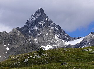
Piz Kesch (German) or Piz d'Es-cha (Rumantsch) is a peak in the Albula Alps of the Rhaetian Alps in Switzerland. At 3,418 metres (11,214 ft), it is the highest peak in the Albula Alps and the municipality of Bergün, Grisons.

Lake Sils is a lake in the Upper Engadine valley, Grisons, Switzerland. It takes its name from the village of Sils im Engadin.

Wolfgang Pass is a high mountain pass in the eastern Swiss Alps in the canton of Grisons in Switzerland.
Scaletta Pass is a mountain pass in the canton of Graubünden, Switzerland. It lies in the Albula Range of the Alps. The path from Dischma leads to Cinuos-chel in the Inn Valley. This means it is a crossing from the German spoken Davos area into the romansh spoken Engadin and additionally a crossing from the northerly drainage basin of the river Rhine flowing into the North Sea and the south side of the drainage divide, emptying its waters into the Black Sea via Inn (river) and Danube. During summer Scaletta pass combines several routes for hikers and Mountainbikers. Instead of just crossing the main pass you can also head via Val Funtauna towards Keschhütte and continue to Bergün. An annual Swiss Alpine Marathon crosses the pass as well.

The Schams is a section of the Hinterrhein valley in the Swiss canton of Graubünden.

The Dischmabach is a river of approximately 15 km long in the river system of Albula. It drains the Dischma valley, its catchment area lies mainly in the area of the Swiss municipality of Davos.
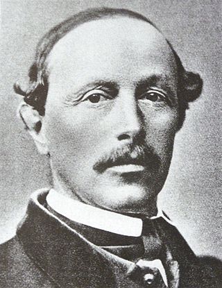
Johann Wilhelm Fortunat Coaz was a Swiss forester, topographer and mountaineer from Graubünden. In 1850 he made the first ascent of Piz Bernina, the highest mountain in the Eastern Alps. He also gave Piz Bernina its name, after the eponymous pass.

Val Fex is a southern side valley from the Upper Engadine in Switzerland, located at an altitude of around 1,800 to 2,000 metres above sea level. It belongs to the municipality of Sils im Engadin/Segl.