Dittmern

Last updated

Dittmern is a village in the borough of Soltau in the Heidekreis district in the German state of Lower Saxony. The village has 783 inhabitants (as at: 2003 [1] ). The hamlets of Friedrichseck, Hambostel, Grüne Aue, Heidenhof and Höpenhof belong to the parish of Dittmern. The Low Saxon name for Dittmern is Dibbern.

Soltau Town in Lower Saxony, Germany

Soltau is a mid-sized town in the Lüneburg Heath in the district of Heidekreis, in Lower Saxony, Germany. It has around 22,000 inhabitants.

Heidekreis District in Lower Saxony, Germany

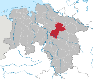
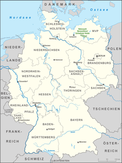
Heidekreis is a district (Landkreis) in Lower Saxony, Germany. It is bounded by the districts of Harburg, Lüneburg, Uelzen, Celle, Hanover, Nienburg, Verden and Rotenburg.

Lower Saxony State in Germany

Lower Saxony is a German state (Land) situated in northwestern Germany. It is the second-largest state by land area, with 47,624 km2 (18,388 sq mi), and fourth-largest in population among the 16 Länder federated as the Federal Republic of Germany. In rural areas, Northern Low Saxon and Saterland Frisian are still spoken, but the number of speakers is declining.

Contents

Dittmern lies on the Lüneburg Heath northeast of Soltau on the Große Aue river. The district roads ( Kreisstraßen ) K 2 and K 9 and the A 7 motorway run through the parish. A motorway junction, Heideregion, in the vicinity of Dittmern, is currently being planned.

Lüneburg Heath landscape, area of heath, geest and woodland in Lower Saxony, Germany

Lüneburg Heath is a large area of heath, geest, and woodland in the northeastern part of the state of Lower Saxony in northern Germany. It forms part of the hinterland for the cities of Hamburg, Hanover and Bremen and is named after the town of Lüneburg. Most of the area is a nature reserve. Northern Low Saxon is still widely spoken in the region.

Kreisstraße class of road in Germany

A Kreisstraße is a class of road in Germany. It carries traffic between the towns and villages within a Kreis or district or between two neighbouring districts. In importance, the Kreisstraße ranks below a Landesstraße, but above a Gemeindestraße or "local road". Kreisstraßen are usually the responsibility of the respective rural district (Landkreis) or urban district, with the exception of high streets through larger towns and villages. Kreisstraßen are usually dual-lane roads but, in a few cases, can be built as limited-access dual carriageways in densely populated areas.

Bundesautobahn 7 federal motorway in Germany

Bundesautobahn 7 is the longest German Autobahn and the longest national motorway in Europe at 963 km (598 mi). It bisects the country almost evenly between east and west. In the north, it starts at the border with Denmark as an extension of the Danish part of E45. In the south, the autobahn ends at the Austrian border. This final gap was closed in September 2009.

The parish chairman is Andreas Wagner-Wischhoff (as at 2008).

Places of interest

Entrance to the Heide Park Eingang Heide-Park Resort 2012.JPG
Entrance to the Heide Park
Heide Park theme park in Soltau, Lower Saxony, Germany

The Heide Park is a theme park in Soltau, Lower Saxony, Germany. With an overall area of over 850,000 m², it is the largest amusement park in Northern Germany and among the largest in the country. It is part of the British-based Merlin Entertainments which operates 123 attractions in 24 countries.

Related Research Articles

Bad Fallingbostel Place in Lower Saxony, Germany

Bad Fallingbostel is the district town (Kreisstadt) of the Heidekreis district in the German state of Lower Saxony. Since 1976 the town has had a state-recognised Kneipp spa and has held the title of Bad since 2002. It has close ties to Walsrode, a few miles to the west. Until 2015, there was a British Army base in Bad Fallingbostel. The town has around 11,000 inhabitants.

Böhme (river) river in Germany

The Böhme is a right-bank, northeastern tributary of the Aller in the district of Soltau-Fallingbostel in the north German state of Lower Saxony. The river is 72 kilometres (45 mi) long.

Bispingen Place in Lower Saxony, Germany

Bispingen is a municipality in the Heidekreis district of Lower Saxony, Germany. It is a popular tourist destination with several holiday/theme parks. Its territory also includes the nature preserve of the Lüneburg Heath around the Wilseder Berg.

Lüneburg Heath Nature Park nature park in Lower Saxony, Germany

Lüneburg Heath Nature Park is a nature park, a form of protected environment, located in the Lüneburg Heath in northern Germany.

Harburg Hills mountain range

The Harburg Hills are a low ridge in the northeastern part of the German state of Lower Saxony and the southern part of the city state of Hamburg. They are up to 155 metres (509 ft) high.

Dat ole Huus museum in Wilsede, Lower Saxony

Dat ole Huus Heath Museum is a local history museum in Wilsede in the German state of Lower Saxony. It was founded in 1907 which makes it one of the oldest open-air museums in Germany. The name is Low German for "That ol' house".

Bremen Switzerland

Bremen Switzerland is an undulating geest landscape in the north of Bremen and the adjacent district of Osterholz, and forms the western portion of the Osterholz Geest. In comparison to the rather flat land on which the city of Bremen is built and its surrounding area which is built on marsh and bog, Bremen Switzerland reaches heights of up to about 30 m above sea level (NN). The region of the Bremen Switzerland is framed by the Weser tributary of Lesum to the south, the Weser to the west, the marsh region of Osterstade to the northwest, the forest of Düngel to the north, the former B 6 federal route to Bremerhaven to the east and the adjoining heath of Lange Heide.

Bundesstraße 214 federal highway in Germany

The Bundesstraße 214 is a federal road that runs from Lingen to Brunswick in North Germany.

Dorfmark human settlement in Germany

The village of Dorfmark is part of the borough of Bad Fallingbostel in Heidekreis district in the German state of Lower Saxony.

Leine-Heide Cycle Path

The Leine-Heide Cycle Path is a long-distance cycle path in Germany that has a total length of 410 kilometres (250 mi) and runs through the German federal states of Thuringia, Lower Saxony and Hamburg. Until 2009 it was called the Leine Cycle Path after the River Leine and ended north of the river's confluence with the Aller in Hodenhagen.

Wiedingen is a village in the borough of Soltau in the district of Soltau-Fallingbostel in the German state of Lower Saxony. The village has 142 inhabitants. The hamlets of Ellingen and Wieheholz belong to the municipality of Wiedingen.

Brock is a village in the borough of Soltau in the Heidekreis district in the German state of Lower Saxony. The village has 158 inhabitants. The hamlets of Bassel, Hebenbrock, Penzhorn and Imbrock are part of the parish.

Deimern is a village in the borough of Soltau in the Heidekreis district in the German state of Lower Saxony. The village has a population of 198. The hamlets of Timmerloh, Harmelingen and Grasengrund belong to the parish of Deimern.

The Vehmsmoor is a nature reserve in North Germany. It is located in the borough of Walsrode within the district of Soltau-Fallingbostel in Lower Saxony. Its classification number is NSG LÜ 182.

Kroge is a village in the parish of Bomlitz in North Germany. It lies in the Lower Saxony district of Soltau-Fallingbostel. The village has 290 inhabitants and an area of 7 square kilometres (2.7 sq mi).

Uetzingen is a village in the parish of Bomlitz in North Germany. It lies in the Lower Saxon district of Soltau-Fallingbostel. The village has 462 inhabitants and its parish covers an area of 10 km².

Nossentiner/Schwinzer Heath Nature Park nature park in Mecklenburg-Vorpommern, Germany

The Nossentiner/Schwinzer Heath Nature Park lies in the western part of the Mecklenburg Lake District in the districts of Mecklenburgische Seenplatte, Rostock and Ludwigslust-Parchim in the north German state of Mecklenburg-Vorpommern. It lies between the towns of Plau am See, Goldberg, Krakow am See and Malchow. It was founded in 1990 and finally confirmed in the state act of 1994. The total area of the nature park is 365 km² of which 60% is wooded, about 14% consists of rivers and lakes and the remainder is cultural landscape. There are almost 60 lakes in the nature park and the rivers Nebel and Mildenitz. Special features of the nature park are the sandar - sand and gravel deposits left by the ice age. Numerous bogs are also dotted across the countryside. The nature park is a breeding ground for white-tailed eagle, osprey und bittern. In addition, wisent are bred on the Damerower Werder. The nature park is easily accessed from the Malchow junction on the A 19 motorway. In the vicinity of the nature park is the Dobbertin Abbey. To the north is the Mecklenburg Switzerland and Lake Kummerow Nature Park and to the northwest the Sternberg Lake District Nature Park.

References

  1. Quelle: "Archived copy" (PDF). Archived from the original (PDF) on 2007-09-27. Retrieved 2010-04-02.

Coordinates: 53°0′53.2″N9°54′39.5″E / 53.014778°N 9.910972°E / 53.014778; 9.910972

Geographic coordinate system Coordinate system

A geographic coordinate system is a coordinate system that enables every location on Earth to be specified by a set of numbers, letters or symbols. The coordinates are often chosen such that one of the numbers represents a vertical position and two or three of the numbers represent a horizontal position; alternatively, a geographic position may be expressed in a combined three-dimensional Cartesian vector. A common choice of coordinates is latitude, longitude and elevation. To specify a location on a plane requires a map projection.