Related Research Articles

Heidekreis is a district (Landkreis) in Lower Saxony, Germany. It is bounded by the districts of Harburg, Lüneburg, Uelzen, Celle, Hanover, Nienburg, Verden and Rotenburg.
Soltau is a mid-sized town in the Lüneburg Heath in the district of Heidekreis, in Lower Saxony, Germany. It has around 22,000 inhabitants. The city is centrally located in the Lüneburg Heath and is known nationwide especially for its tourist attractions like the Heide-Park and the Soltau-Therme.

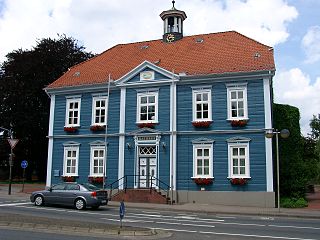
Bad Fallingbostel is the district town (Kreisstadt) of the Heidekreis district in the German state of Lower Saxony. Since 1976 the town has had a state-recognised Kneipp spa and has held the title of Bad since 2002. It has close ties to Walsrode, a few miles to the west. Until 2015, there was a British Army base in Bad Fallingbostel, It also hosted Defender 2020 the largest US Army/Nato exercise since the Cold war. The town has around 11,000 inhabitants.

Magor is a large village in Monmouthshire, south east Wales, about 9 miles (14 km) west of Chepstow and about 9 miles (14 km) east of Newport. It lies on the Caldicot Levels beside the Severn Estuary, and is in the community of Magor with Undy. Magor lies close to the M4 motorway.

Addington is a village in the English county of Kent. It is close to the M20 motorway, and between the villages of Wrotham Heath and West Malling. In the Domesday Book of 1086 it is called Eddintune. The meaning of the village's name is "Æddi's estate". The village is notable for the long barrows, Neolithic chamber tombs. Its parish covers a little under 700 acres (2.8 km2), containing 291 houses. Addington Brook runs through the parish.
Clayton Brook is a large residential estate in Lancashire, between the city of Preston and the town of Chorley. It forms part of the Clayton-le-Woods civil parish, and is in the Clayton-le-Woods North ward of the borough of Chorley. Lying next to the industrial estate of Walton Summit, one-time terminus of a branch of the Lancaster Canal, it also neighbours Clayton Green, Hoghton and Brindle, and is not far from the small town of Bamber Bridge. Clayton Brook Village as it is often termed, is bounded by the A6 road and the M61 and M65 motorways, and is conveniently near the M6 motorway.

A High-quality dual carriageway (HQDC) is a road category in Ireland. It is defined as an all-purpose dual carriageway road type built to near motorway standards, but without motorway classification or motorway restrictions. High-quality dual carriageways have full grade-separated access and do not have junctions with minor roads. Such roads in the Republic of Ireland have been built as part of the 2000–2006 and 2007–2013 National Development Plans, including interurban routes from Dublin to other cities.

Handeloh is a municipality in the district of Harburg, in Lower Saxony, Germany.

Strensham is a village in the Wychavon district of Worcestershire. In the 2001 census, the civil parish of Strensham had a population of 314 across 127 households. Since 1991, the population has risen 28.7% from 244 residents.

The village of Dorfmark is part of the borough of Bad Fallingbostel in Heidekreis district in the German state of Lower Saxony.
Wiedingen is a village in the borough of Soltau in the district of Soltau-Fallingbostel in the German state of Lower Saxony. The village has 142 inhabitants. The hamlets of Ellingen and Wieheholz belong to the municipality of Wiedingen.
Deimern is a village in the borough of Soltau in the Heidekreis district in the German state of Lower Saxony. The village has a population of 198. The hamlets of Timmerloh, Harmelingen and Grasengrund belong to the parish of Deimern.
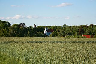
Dittmern is a village in the borough of Soltau in the Heidekreis district in the German state of Lower Saxony. The village has 783 inhabitants. The hamlets of Friedrichseck, Hambostel, Grüne Aue, Heidenhof and Höpenhof belong to the parish of Dittmern. The Low Saxon name for Dittmern is Dibbern.
The Vehmsmoor is a nature reserve in North Germany. It is located in the borough of Walsrode within the district of Soltau-Fallingbostel in Lower Saxony. Its classification number is NSG LÜ 182.
Kroge is a village in the town of Walsrode in North Germany. It lies in the Lower Saxony district of Soltau-Fallingbostel. The village has 290 inhabitants and an area of 7 square kilometres (2.7 sq mi).
Uetzingen is a village in the town of Walsrode in North Germany. It lies in the Lower Saxon district of Heidekreis. The village has 462 inhabitants and its parish covers an area of 10 km².
Bommelsen is a village in the town of Walsrode in North Germany. It lies in the Lower Saxon Heidekreis district. The parish has about 286 inhabitants and an area of 10 km².
Bockhorn is a parish in the borough of Walsrode in the Heidekreis district in the Lüneburg Heath in the north German state of Lower Saxony. About 290 people live in this heath parish which has an area of 9.0 km².

Myerscough and Bilsborrow is a civil parish in the Borough of Wyre in Lancashire, England. It was formed on 1 April 2003 as a merger of the former parishes of Bilsborrow and Myerscough, and lies on the eastern border of the Fylde plain.
Long Whatton and Diseworth is a civil parish in the North West Leicestershire district of Leicestershire, England. The parish includes the villages of Long Whatton and Diseworth. The population of the parish at the 2011 census was 1,760.
References
- ↑ Quelle: "Archived copy" (PDF). Archived from the original (PDF) on 2007-09-27. Retrieved 2010-04-02.
{{cite web}}: CS1 maint: archived copy as title (link)
Villages in the borough of Soltau | ||
|---|---|---|
Coordinates: 52°56′34.161″N9°50′29.48″E / 52.94282250°N 9.8415222°E
| | This Heidekreis location article is a stub. You can help Wikipedia by expanding it. |