
The Ramapo Mountains are a forested chain of the Appalachian Mountains in northeastern New Jersey and southeastern New York, in the United States. They range in height from 900 to 1,200 feet in New Jersey, and 900 to 1,400 feet in New York.
The Delaware River and Bay Authority or DRBA is a bi-state government agency of the U.S. states of New Jersey and Delaware established by interstate compact in 1962.
The Courier-Post is a morning daily newspaper that serves South Jersey near Philadelphia, Pennsylvania. While based in Cherry Hill, New Jersey, United States, it serves most of Burlington, Camden, and Gloucester counties. The paper has 30,313 daily paid subscribers and 41,078 on Sunday.
One of the twenty-two Apostle Islands of northern Wisconsin, Manitou Island has also been known as New Jersey Island and Tait's Island.
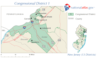
New Jersey's 1st congressional district is a congressional district in the U.S. state of New Jersey.

Salem Community College (SCC) is an accredited, co-educational, two-year public, community college located in Salem County, New Jersey. Salem Community College's main 11-acre (45,000 m2) campus is in Carneys Point Township. SCC is authorized to grant associate degrees—Associate in Arts, Associate in Fine Arts, Associate in Science and Associate in Applied Science—and certificates in over 40 liberal arts, business, practical nursing, and technology programs of study. SCC also offers the only degree program in the US for scientific glassblowing.
The Delaware River Region refers to an area in western New Jersey (USA) along the Delaware River border with Pennsylvania. It encompasses Burlington County, Camden County, Gloucester County, Mercer County, and Salem County. The area is primarily part of Greater Philadelphia with the exception of Mercer County, which is part of the New York City Metropolitan Area. It is one of six officially recognized tourism regions by the New Jersey Department of Tourism, the others being the Greater Atlantic City Region, the Skylands Region, the Southern Shore Region, the Shore Region and the Gateway Region.
Merchantville Country Club is a 9-hole course located in Cherry Hill, New Jersey. The club was founded on October 13, 1892 under the name Merchantville Field Club. In 1911, national attention was focused on Merchantville Country Club when their head professional John McDermott, became the first American born professional to win the U.S. Open in 1912.
The Salem County Vocational Technical Schools (SCVTS) is a countywide vocational and technical public school district, serving the educational needs of residents of Salem County, New Jersey, United States. The district offers programs on both a full-time and shared-time basis in cooperation and partnership with the county's elementary and secondary schools, local and regional colleges and universities, for both school-aged students and adults.

The Battleship New Jersey Museum and Memorial is located at 62 Battleship Place, Camden, New Jersey, United States. This museum ship preserves and displays the USS New Jersey (BB-62), the most decorated battleship to have served in the U.S. Navy and one of the largest ever built.
The Woodlynne School District is a community public school district that serves students in pre-kindergarten through eighth grade from Woodlynne, in Camden County, New Jersey, United States.
The Gloucester County Vocational-Technical School District is a vocational public school district located in the Sewell section of Mantua Township, serving the vocational and educational needs of bothpublic high school students in ninth through twelfth grades and adult students across Gloucester County, New Jersey, United States.
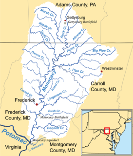
Double Pipe Creek, sometimes called Pipe Creek, is a major tributary of the Monocacy River in Carroll County and Frederick County in Maryland, located several miles north and west of Westminster. The creek is only 1.6 miles (2.6 km) long, but is formed by the confluence of two much longer streams, Big Pipe Creek and Little Pipe Creek.

Centerton is an unincorporated community located within Pittsgrove Township, in Salem County, New Jersey, United States. County Route 540 is a major road that travels through Centerton and passes Centerton Pond. Route 55 provides access to Centerton, via exit 45. Centerton is approximately 5 miles (8.0 km) west of Vineland in Cumberland County.
Wrights Mill is an unincorporated community located within Elk Township in Gloucester County, New Jersey, United States. It is located at 39.685°N 75.176°W. The elevation is 105 feet.

The South Camden Trust Company building is located within the Waterfront South area of Camden, New Jersey and was listed on the state and federal registers of historic places in 1990. Built in the 1920s, it has long functioned as a church.
Canton is an unincorporated community located within Lower Alloways Creek Township, in Salem County, New Jersey, United States. It is located approximately 7 miles (11 km) southeast of Salem.
The Isaac Glover House is located in Haddon Heights, Camden County, New Jersey, United States. The house was built c. 1750 and added to the National Register of Historic Places on September 23, 1994.
The Gloucester County Special Services School District is a special education public school district headquartered in the Sewell section of Mantua Township, in Gloucester County, New Jersey, United States, whose schools offer educational and therapeutic services for students of elementary and high school age from across the county who have emotional of physical disabilities that cannot be addressed by their sending districts.
Porchtown is an unincorporated area in Gloucester County, New Jersey.


