
Etawah is a city on the banks of Yamuna River in the state of Western Uttar Pradesh in India. It is the administrative headquarters of Etawah District. Etawah's population of 256,838 makes it the one hundred and eightieth-most populous city in India. The city lies 300 km (190 mi) southeast of the national capital New Delhi, and 190 km (120 mi) northwest of the state capital Lucknow

Mainpuri is a city in Mainpuri district in the Indian state of Uttar Pradesh. It is the administrative headquarters of Mainpuri district and is situated to the north-east of Agra and is 270 km from New Delhi. Mainpuri forms part of ancient legendary region of Lord Krishna's land called Braj.

Firozabad is a city near Agra in the state of Uttar Pradesh in India. It is the centre of India's glassmaking industry and is known for the quality of the bangles and also glasswares produced there.

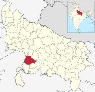
Etawah district is one of the districts in the western portion of Uttar Pradesh state of India. Etawah town is the district headquarters. The district covers an area of 2311 km2. It has a population of 1,581,810.
Jalaun district is a district of Uttar Pradesh, India. The district is named after the town of Jalaun, which was the former headquarters of a Maratha governor, but the administrative headquarters of the district is at Orai. Other large towns in the district are Konch, Kalpi, and Madhogarh.
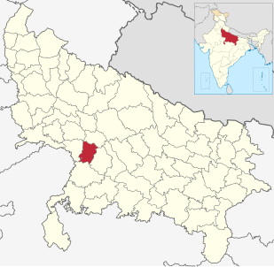
Firozabad district forms one of the western districts of the Indian state of Uttar Pradesh, which has Firozabad Town as its district headquarters. The district is a part of the Agra division.
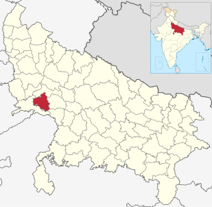
Mainpuri district is one of the districts in Agra division of Uttar Pradesh state of India. Mainpuri town is the district headquarters. It consists of six tehsils, namely Mainpuri, Bhongaon, Karhal, Kishni, kurawali and Ghiror.
Auraiya is a city and a municipal board in Auraiya district in the state of Uttar Pradesh, India. NH 19 passes through the center of the town. Phaphund railway station is nearest Railway Station. Saifai Airstrip is the nearest aviation facility, having limited private use. Nearest commercial airport is the Kanpur Airport.
Bakewar is a town and a nagar panchayat in Etawah district in the state of Uttar Pradesh, India. It is 22 km from district headquarters Etawah. Bakewar is famous for its very good education system, Agriculture Training Institute and for National highway no. 2. Bakewar is situated at national highway no. 2. It is between Agra and Kanpur, the two biggest cities of Uttar Pradesh. Agra is 145 km north and Kanpur is 135 km on south of Bakewar. Bharthana is the nearest railway (11 km) of Bakewar, situated in the east.
Bharthana is a city and a municipal board in Etawah district in the state of Uttar Pradesh, India. Bharthana is located at 26.75°N 79.23°E. It has an average elevation of 135 metres (442 feet).
Ekdil is a town and a nagar panchayat in Etawah district in the state of Uttar Pradesh, India. This place was established by the Ekdil Khan. It was earlier known as Sarai Rupa. In the 17th century, a eunuch named Ekdil Khan came here, and built a new sarai, which he named Ekdil, This town is located at National Highway No.2. It is just 9 kilometers from Etawah. It has a small railway station on the north side named EKDIL. Distance of railway station 3 kilometers from Ekdil town.Ekdil had a population of 11310.
Karhal is a city with Nagar Palika Parishad in Mainpuri district in the Indian state of Uttar Pradesh. It is a tehsil in Mainpuri District which belongs to Agra division. It is one of the five Vidhan Sabha segments of Mainpuri Lok Sabha constituency. Karhal has two blocks as Karhal and Baranahal.
Saurikh is a nagar panchayat in Kannauj district in the Indian state of Uttar Pradesh. Its old name was Sau-Rishi.
Tundla is a town and a municipal board in Firozabad district in the Indian state of Uttar Pradesh.It is famous for its catholic Church build in 1860 and its happy and open-hearted people.
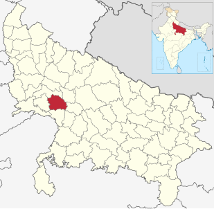
Auraiya district is one of the districts of Uttar Pradesh state of India, and Auraiya town is the district headquarters. It lies on the south-western portion of Uttar Pradesh and also forms a part of the Kanpur Division.
Bidhuna is a big town and a Nagar Panchayat in Auraiya district in the state of Uttar Pradesh, India. Bidhuna has some temples. Durga Devi Mandir is one of the oldest temple in the town. Bidhuna also have known as priest people live in bidhuna and around the town. Kotwali situated near State Bank of India, feeder road. Feeder road as like as Cannaught place of Bidhuna. famous market of Bidhuna Loha Mandi, Sabji Mandi, Gala Mandi, Takiya also most famous place. It is also a educational hub for surrounding villages. It has several degree colleges and good quality schools which attract numerous students.
The Kanpur–Delhi section is a railway line connecting Kanpur Central and Delhi. This section includes Agra Chord and Etah link. The main line is part of Howrah-Delhi main line and Howrah-Gaya-Delhi line. The Agra-Delhi chord is part of Delhi-Mumbai line and Delhi-Chennai line.
Saifai is a large village in the Etawah district and Mainpuri Parliamentary constituency of Indian state Uttar Pradesh. It is also a sub-division (Tehsil) and Block of the Etawah district. It is the birthplace of Mulayam Singh Yadav, founding president of Samajwadi Party, former Minister of Defence and former Chief Minister of Uttar Pradesh. According to newspaper The Hindu, Saifai is in a process to establish itself as a sports and education hub in the state.

Takha is a village in the Etawah district Uttar Pradesh. It is also a Sub-Division (Tehsil) and Block of the Etawah district.

Sarsai Nawar is a large village in the Etawah district of Uttar Pradesh, India. It is 329 kilometres (204 mi) south of the national capital New Delhi.

