Dixie Terminal

Last updated
Dixie Terminal North Building - Fourth and Walnut Streets DixieTerminalExterior.jpg
Dixie Terminal North Building - Fourth and Walnut Streets

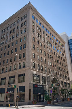
The Dixie Terminal is a set of buildings in Cincinnati, Ohio, that were completed in 1921 and served as a streetcar terminal, stock exchange, and office building in the city's downtown business district. They were designed by Cincinnati architect Frederick W. Garber's Garber & Woodward firm. [1] [2] The main building includes an Adamesque barrel-vaulted concourse and Rookwood Architectural Faience entry arch. [3] The Rookwood tiles were manufactured by the local Rookwood Pottery Company.

Contents

At Fourth and Walnut Streets, the terminal was constructed of reinforced concrete and finished in gray brick, Bedford limestone, and granite. [1] It includes two structures: the four-story south building extending to Third Street, where streetcars entered and left, and the "handsome" 10-story north building, housing railroad ticket agencies, the Cincinnati Stock Exchange, administrative offices of the Cincinnati Street Railway Company, commercial offices, and shops. [4]

A long and elaborate arcade runs through from main entrance through the building, lined by shops. The building included marble floors, Bottincino marble wainscot, metal trimmings, and "costly brightly decorated ceilings, with fanciful medallions showing little children riding on the backs of various animals". [4]

The terminal was used for bus service after streetcar service ceased in the 1950s. Buses arriving from northern Kentucky crossed the Roebling Suspension Bridge and took ramps from the bridge into the terminal. In 1998 the ramps were removed, and the bus service ceased using the terminal. The Cincinnati Stock Exchange closed its physical trading floor in 1976 after becoming an all-electronic stock trading exchange but remained in the building until relocating to Chicago in 1995 as the National Stock Exchange. [1]

A scene in the 1988 film Rain Man was shot at Dixie Terminal. [5]

39°06′00″N84°30′41″W / 39.099937°N 84.511334°W / 39.099937; -84.511334

Ornament and decoration

Dixie Terminal Entrance Dixie Terminal Entrance, September 2010.jpg
Dixie Terminal Entrance

Joseph Francis Beller is believed responsible for the original gold-leafing and the "frolicking" cherubs in the building. [6]

See also

Related Research Articles

<span class="mw-page-title-main">Norwood, Ohio</span> City in Ohio, United States

Norwood is the third most populous city in Hamilton County, Ohio, United States, and an enclave of the larger city of Cincinnati. The population was 19,043 at the 2020 census. Originally settled as an early suburb of Cincinnati in the wooded countryside north of the city, the area is characterized by older homes and tree-lined streets.

<span class="mw-page-title-main">John A. Roebling</span> German-American engineer (1806–1869)

John Augustus Roebling was a German-born American civil engineer. He designed and built wire rope suspension bridges, in particular the Brooklyn Bridge, which has been designated as a National Historic Landmark and a National Historic Civil Engineering Landmark.

<span class="mw-page-title-main">John A. Roebling Suspension Bridge</span> Suspension bridge between the Ohio River

The John A. Roebling Suspension Bridge is a suspension bridge that spans the Ohio River between Cincinnati, Ohio, and Covington, Kentucky. When opened on December 1, 1866, it was the longest suspension bridge in the world at 1,057 feet (322 m) main span, which was later overtaken by John A. Roebling's most famous design of the 1883 Brooklyn Bridge at 1,595.5 feet (486.3 m). Pedestrians use the bridge to get between the hotels, bars, restaurants, and parking lots in Northern Kentucky. The bar and restaurant district at the foot of the bridge on the Kentucky side is known as Roebling Point.

<span class="mw-page-title-main">Newark Public Service Terminal</span>

The Public Service Terminal was a three-level streetcar station in Newark, New Jersey, owned and operated by the Public Service Corporation, adjacent to the Hudson and Manhattan Railroad's Park Place station. It served as the terminus for streetcar lines from as far as Trenton. Public Service was both a transportation company and a utility, providing electric and gas service to much of northern New Jersey. The six office stories above the terminal served as company headquarters.

<span class="mw-page-title-main">Big Pig Gig</span>

The Big Pig Gig and Big Pig Gig: Do-Re-Wee were public art exhibits on display in Cincinnati, Ohio, United States, in the summers of 2000 and 2012, respectively. Local artists and schools decorated hundreds of full-sized fiberglass pig statues and installed them throughout the downtown area. The events were organized by ArtWorks, a community art employment program.

<span class="mw-page-title-main">Cincinnati Union Terminal</span> Train station in Cincinnati, Ohio

Cincinnati Union Terminal is an intercity train station and museum center in the Queensgate neighborhood of Cincinnati, Ohio. Commonly abbreviated as CUT, or by its Amtrak station code, CIN, the terminal is served by Amtrak's Cardinal line, passing through Cincinnati three times weekly. The building's largest tenant is the Cincinnati Museum Center, comprising the Cincinnati History Museum, the Museum of Natural History & Science, Duke Energy Children's Museum, the Cincinnati History Library and Archives, and an Omnimax theater.

<span class="mw-page-title-main">Barney Circle</span> Neighborhood in the United States

Barney Circle is a small residential neighborhood located between the west bank of the Anacostia River and the eastern edge of Capitol Hill in southeast Washington, D.C., in the United States. The neighborhood is characterized by its sense of community, activism, walkability, and historic feel. The neighborhood's name derives from the eponymous former traffic circle Pennsylvania Avenue SE just before it crosses the John Philip Sousa Bridge over the Anacostia. The traffic circle is named for Commodore Joshua Barney, Commander of the Chesapeake Bay Flotilla in the War of 1812.

<span class="mw-page-title-main">Fort Washington Way</span>

Fort Washington Way is an approximately 0.9-mile-long (1.4 km) section of freeway in downtown Cincinnati, Ohio, United States. The eight-lane divided highway is a concurrent section of Interstate 71 (I-71) and U.S. Route 50 (US 50) that runs from west to east from an interchange with I-75 at the Brent Spence Bridge to the Lytle Tunnel and Columbia Parkway.

<span class="mw-page-title-main">Saskatoon Transit</span> Public transport system in Saskatchewan, Canada

Saskatoon Transit is the public transport arm of the City of Saskatoon, Saskatchewan, Canada. It operates a fleet of diesel buses. A total of 23 bus routes serve every area of the city, carrying approximately 11 million passengers in 2008. Saskatoon Transit is a member of the Canadian Urban Transit Association. The major bus terminal is located Downtown.

The Capital Traction Company was the smaller of the two major street railway companies in Washington, D.C., in the early 20th century.

<span class="mw-page-title-main">The Ascent at Roebling's Bridge</span> Residential building in Covington, Kentucky

The Ascent at Roebling's Bridge is a residential building in Covington, Kentucky, United States, in the greater Cincinnati area. Designed by Daniel Libeskind, the building sits along the Ohio River across from the Roebling Suspension Bridge. It was commissioned in 2004 and was completed in March 2008 at a cost of approximately $50 million. Many newspapers have associated the Ascent with a trend toward signature architecture for residential buildings.

Roebling Point is an area of Covington, northern Kentucky, located at the foot of the John A. Roebling Suspension Bridge. This neighborhood is going through extensive changes. Since August 2007, The Ascent at Roebling's Bridge, has spurred on a rejuvenation of the neighborhood. Many bars and restaurants have opened there in the last year, Coco's Funk n' Blues Cafe, The Keystone Bar & Grill, Molly Malone's Irish Pub, The Down Under Tavern, Chalk, and Greenup Cafe are all located here.

Ammann & Whitney was a full-service Civil engineering firm that provided design and construction services for public and private sector projects. The firm provided new construction, renovations, adaptive reuse, historic preservation, interior design and sustainable design.

<span class="mw-page-title-main">Connector (Cincinnati)</span> Streetcar system in Cincinnati, Ohio, U.S.

The Connector is a streetcar system in Cincinnati, Ohio, United States. The system opened to passengers on September 9, 2016. The streetcar operates on a 3.6-mile (5.8 km) loop from The Banks, Great American Ball Park, and Smale Riverfront Park through Downtown Cincinnati and north to Findlay Market in the northern edge of the Over-the-Rhine neighborhood. Future extensions have been proposed to the Uptown area, home to the University of Cincinnati, the regional hospitals on Pill Hill, and the Cincinnati Zoo; and to Northern Kentucky.

<span class="mw-page-title-main">Frederick W. Garber</span>

Frederick W. Garber was an American architect in Cincinnati, Ohio and the principal architect in the Garber & Woodward firm with Clifford B. Woodward (1880–1932). The firm operated from 1904 until it was dissolved in 1933 Their work has been described as in the Beaux-Arts tradition and included buildings on the University of Cincinnati campuses, schools, hospitals, commercial buildings, "fine residences" and public housing.

<span class="mw-page-title-main">Rookwood Pottery Company</span> United States historic place

Rookwood Pottery is an American ceramics company that was founded in 1880 and closed in 1967, before being revived in 2004. It was initially located in the Over-the-Rhine neighborhood in Cincinnati, Ohio, and has now returned there. In its heyday from about 1890 to the 1929 Crash, it was an important manufacturer, mostly of decorative American art pottery made in several fashionable styles and types of pieces.

The following is a timeline of the history of the city of Cincinnati, Ohio, USA.

<span class="mw-page-title-main">Transportation in Cincinnati</span>

Transportation in Cincinnati includes sidewalks, roads, public transit, bicycle paths, and regional and international airports. Most trips are made by car, with transit and bicycles having a relatively low share of total trips; in a region of just over 2 million people, less than 80,000 trips are made with transit on an average day. The city is sliced by three major interstate highways, I-71, I-74 and I-75, and circled by a beltway several miles out from the city limits. The region is served by two separate transit systems, one on each side of the river. SORTA, on the Ohio side is about six times larger than TANK on the Kentucky side.

<span class="mw-page-title-main">Williamsburg Bridge Plaza Bus Terminal</span> Bus terminal in Brooklyn, New York

The Williamsburg Bridge Plaza, sometimes called Washington Plaza or the Williamsburg Bridge Transit Center, is a major bus terminal and former trolley terminal located at the foot of the Williamsburg Bridge in the New York City borough of Brooklyn, one block west of the Brooklyn-Queens Expressway (I-278). It is situated by the boundaries of Broadway, Havemeyer Street, Roebling Street, and South 5th Street, south of the LaGuardia Playground. It contains five bus lanes, and serves as a terminal for numerous MTA New York City Transit Authority bus routes of Brooklyn and Queens that start and end their runs there.

<span class="mw-page-title-main">Cincinnati metropolitan area</span> Metropolitan area in the United States

The Cincinnati metropolitan area is a metropolitan area with its core in Ohio and Kentucky. Its largest city is Cincinnati and includes surrounding counties in the U.S. states of Ohio, Kentucky, and Indiana.

References

  1. 1 2 3 "Dixie Terminal Building". Waymarking. 27 April 2008. Retrieved 2015-07-06.
  2. "John A. Roebling Suspension Bridge". Cincinnati transit. Retrieved 2015-07-06.
  3. "Unknown Ref". University of Cincinnati. Archived from the original on September 10, 2009.
  4. 1 2 "Tour 4". Cincinnati: A Guide to the Queen City and Its Neighbors 1943. Cincinnati Historical Society. June 1987. p. 174. ISBN   978-0911497045.
  5. "Then and Now: A look back at 'Rain Man' in Cincinnati and Northern Kentucky". WCPO-TV News. February 28, 2014. Retrieved 2 April 2014.
  6. "Dixie Terminal Redux". VisuaLingual. 13 November 2008. Retrieved 2015-07-06.