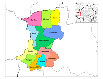
Janakpur is one of the fourteen zones of Nepal, reaching from the Indian border in the south to the Tibetan border in the north and Sagarmatha Zone in the east and Bagmati and Naryani Zones in the west.

St. Bride's is a small town on the Cape Shore of Newfoundland, Canada. Located 166 km Southwest of the capital of Newfoundland and Labrador, St. John's, St. Bride's is a fishing community with a population of approximately 386 persons as of 2006. The largest codfish ever caught, weighing in at 125 lbs, was landed here in 1905.

Tierralta is a town and municipality located in the Córdoba Department, northern Colombia.

Líbano is a town and municipality in the Tolima department of Colombia. The population of the municipality was 41,650 as of the 2005 census. Along with Honda, Tolima, Líbano is the seat of the Roman Catholic Diocese of Líbano–Honda.

Choam Khsant District is a district located in Preah Vihear Province, in northern Cambodia. The district capital is at Cheom Ksan town, near the Thai border. Cambodia's famous Preah Vihear Temple is located in this district of the Preah Vihear province. According to the 1998 census of Cambodia, it had a population of 16,073.
Pescueza is a municipality located in the province of Cáceres, Extremadura, Spain. According to the 2005 census (INE), the municipality has a population of 167 inhabitants.

Calmarza is a municipality located in the province of Zaragoza, Aragon, Spain. According to the 2010 census the municipality has a population of 77 inhabitants.
Lapinlahti is a quarter in Helsinki, part of the Länsisatama neighbourhood.

Babino is a village in the administrative district of Gmina Choroszcz, within Białystok County, Podlaskie Voivodeship, in north-eastern Poland. It lies approximately 6 kilometres (4 mi) north-west of Choroszcz and 18 km (11 mi) west of the regional capital Białystok.
Kogoue is a town in the Sidéradougou Department of Comoé Province in south-western Burkina Faso. The town has a population of 1,206.
Ulatowo-Adamy is a village in the administrative district of Gmina Krzynowłoga Mała, within Przasnysz County, Masovian Voivodeship, in east-central Poland. It lies approximately 17 kilometres (11 mi) north of Przasnysz and 106 km (66 mi) north of Warsaw.

San Miguel del Puerto is a town and municipality in Oaxaca in south-western Mexico. The municipality covers an area of 488.6 km². It is part of the Pochutla District in the east of the Costa Region.

The Swinburne Ice Shelf, is an ice shelf just north of Edward VII Peninsula and the Alexandra Mountains in the southern part of Sulzberger Bay, Antarctica. The ice shelf is 20 miles long and 5 miles wide and extends from Fisher Island to White Islands. It was photographed from aircraft and mapped by the Byrd Antarctic Expedition (ByrdAE), 1928-30. Named by Advisory Committee on Antarctic Names (US-ACAN) for Captain H.W Swinburne, Jr., Deputy Commander and Chief of Staff, U.S. Naval Support Force, Antarctica, during Operation Deep Freeze 1970 and 1971.
Long Khánh is a district-level town of Đồng Nai Province in the Southeast region of Vietnam. As of 2003, the district had a population of 137,444. The district covers an area of 194 km². The district capital lies at Long Khánh.
Laukna is a village in Märjamaa Parish, Rapla County in western Estonia.

The borders of the oceans are the limits of the Earth's oceanic waters. The definition and number of oceans can vary depending on the adopted criteria.

Mudiyah District is a district of the Abyan Governorate, Yemen. As of 2003, the district had a population of 34,879 inhabitants.

Mincer Glacier is a broad glacier flowing from Zuhn Bluff into the southeast arm of Murphy Inlet on the north side of Thurston Island, Antarctica. It was named by the Advisory Committee on Antarctic Names after Lieutenant Dale F. Mincer, a co-pilot of PBM Mariner aircraft in the Eastern Group of U.S. Navy Operation Highjump, which obtained aerial photographs of Thurston Island and adjacent coastal areas in 1946–47.

Rostock is a district in the north of Mecklenburg-Vorpommern, Germany. It is bounded by the district Nordwestmecklenburg, the Baltic Sea, the district-free city Rostock and the districts Vorpommern-Rügen, Mecklenburgische Seenplatte and Ludwigslust-Parchim. The district seat is the town Güstrow.
Spring Garden is a village in Guyana. It is located on the Essequibo coast, next to Good Hope village. It is two villages away from Supenaam. The population consists of mostly East Indians.