
Mierendorffplatz is a station on the Berlin U-Bahn U 7 line in Charlottenburg. It was opened on 1 October 1980 with the line's extension from Richard-Wagner-Platz to Rohrdamm. The eponymous square is named after politician and Resistance fighter Carlo Mierendorff (1897–1943). Architect Rümmler designed this station walls like the pattern of a M as in Mierendorffplatz. The next station is Richard Wagner Platz.
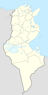
La Goulette is the port of Tunis, the capital of Tunisia. The Kasbah fortress was built in 1535 by Charles I of Spain but was captured by the Ottoman Turks in 1574. La Goulette is located at around 36°49′5″N10°18′18″E.

Dąbrowa is a village in the administrative district of Gmina Przesmyki, within Siedlce County, Masovian Voivodeship, in east-central Poland. It lies approximately 6 kilometres (4 mi) north-east of Przesmyki, 29 km (18 mi) north-east of Siedlce, and 112 km (70 mi) east of Warsaw.
Dąbek is a village in the administrative district of Gmina Strzelno, within Mogilno County, Kuyavian-Pomeranian Voivodeship, in north-central Poland.
Spławy Pierwsze is a village in the administrative district of Gmina Kraśnik, within Kraśnik County, Lublin Voivodeship, in eastern Poland. It lies approximately 3 kilometres (2 mi) west of Kraśnik and 46 km (29 mi) south-west of the regional capital Lublin.
Doleck is a village in the administrative district of Gmina Nowy Kawęczyn, within Skierniewice County, Łódź Voivodeship, in central Poland. It lies approximately 5 kilometres (3 mi) north-east of Nowy Kawęczyn, 13 km (8 mi) south-east of Skierniewice, and 60 km (37 mi) east of the regional capital Łódź.
Kamyszów is a village in the administrative district of Gmina Kazimierza Wielka, within Kazimierza County, Świętokrzyskie Voivodeship, in south-central Poland. It lies approximately 4 kilometres (2 mi) north of Kazimierza Wielka and 65 km (40 mi) south of the regional capital Kielce.

Lipie is a village in the administrative district of Gmina Czarna, within Bieszczady County, Subcarpathian Voivodeship, in south-eastern Poland, close to the border with Ukraine. It lies approximately 4 kilometres (2 mi) south-east of Czarna, 17 km (11 mi) south-east of Ustrzyki Dolne, and 96 km (60 mi) south-east of the regional capital Rzeszów.

Gręzów is a village in the administrative district of Gmina Kotuń, within Siedlce County, Masovian Voivodeship, in east-central Poland. It lies approximately 5 kilometres (3 mi) east of Kotuń, 10 km (6 mi) west of Siedlce, and 78 km (48 mi) east of Warsaw.
Tokarki Drugie is a settlement in the administrative district of Gmina Kazimierz Biskupi, within Konin County, Greater Poland Voivodeship, in west-central Poland.
Trzęśniew Mały is a village in the administrative district of Gmina Kościelec, within Koło County, Greater Poland Voivodeship, in west-central Poland. It lies approximately 5 kilometres (3 mi) west of Kościelec, 9 km (6 mi) west of Koło, and 112 km (70 mi) east of the regional capital Poznań.
Bierzglinek is a village in the administrative district of Gmina Września, within Września County, Greater Poland Voivodeship, in west-central Poland. It lies approximately 4 kilometres (2 mi) south of Września and 46 km (29 mi) east of the regional capital Poznań.
Sokolna is a village in the administrative district of Gmina Tarnówka, within Złotów County, Greater Poland Voivodeship, in west-central Poland. It lies approximately 5 kilometres (3 mi) south-east of Tarnówka, 13 km (8 mi) south-west of Złotów, and 101 km (63 mi) north of the regional capital Poznań.
Kujanki is a settlement in the administrative district of Gmina Zakrzewo, within Złotów County, Greater Poland Voivodeship, in west-central Poland. It lies approximately 5 kilometres (3 mi) south-east of Zakrzewo, 10 km (6 mi) east of Złotów, and 110 km (68 mi) north of the regional capital Poznań.

Sławików is a village in the administrative district of Gmina Rudnik, within Racibórz County, Silesian Voivodeship, in southern Poland. It lies approximately 7 kilometres (4 mi) north-east of Rudnik, 12 km (7 mi) north of Racibórz, and 56 km (35 mi) west of the regional capital Katowice.
Bystra is a village in the administrative district of Gmina Pruszcz Gdański, within Gdańsk County, Pomeranian Voivodeship, in northern Poland. It lies approximately 10 kilometres (6 mi) north-east of Pruszcz Gdański and 11 km (7 mi) south-east of the regional capital Gdańsk.
Szeszki is a village in the administrative district of Gmina Kowale Oleckie, within Olecko County, Warmian-Masurian Voivodeship, in northern Poland. It lies approximately 5 kilometres (3 mi) north-west of Kowale Oleckie, 20 km (12 mi) north-west of Olecko, and 129 km (80 mi) east of the regional capital Olsztyn.
Puzary is a village in the administrative district of Gmina Szczytno, within Szczytno County, Warmian-Masurian Voivodeship, in northern Poland.
Kluczewo is a village in the administrative district of Gmina Czaplinek, within Drawsko County, West Pomeranian Voivodeship, in north-western Poland. It lies approximately 12 kilometres (7 mi) north of Czaplinek, 29 km (18 mi) north-east of Drawsko Pomorskie, and 110 km (68 mi) east of the regional capital Szczecin.
Anzourou is a village and rural commune in Niger.


