
Murray County is a county located in the southern part of the U.S. state of Oklahoma. As of the 2020 census, the population was 13,904. The county seat is Sulphur. The county was named for William H. Murray, a member and president of the Oklahoma Constitutional Convention and later a Governor of Oklahoma.

Choctaw County is a county located in the U.S. state of Oklahoma. As of the 2020 census, the population was 14,204. Its county seat is Hugo.

The Chickasaw are an Indigenous people of the Southeastern Woodlands, United States. Their traditional territory was in northern Mississippi, northwestern and northern Alabama, western Tennessee and southwestern Kentucky. Their language is classified as a member of the Muskogean language family. In the present day, they are organized as the federally recognized Chickasaw Nation.

Fort Towson is a town in Choctaw County, Oklahoma, United States. The population was 510 at the 2010 census, a 15.1 percent decline from the figure of 611 recorded in 2000. It was named for nearby Fort Towson, which had been established in May 1824 and named for General Nathan Towson, a hero of the War of 1812. The town of Fort Towson was established in 1902, after the Arkansas and Choctaw Railway reached eastern Choctaw County.
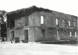
Fort Towson was a frontier outpost for Frontier Army Quartermasters along the Permanent Indian Frontier located about two miles (3 km) northeast of the present community of Fort Towson, Oklahoma. Located on Gates Creek near the confluence of the Kiamichi River and the Red River in present-day Choctaw County, Oklahoma, it was named for General Nathaniel Towson.
Skullyville is an unincorporated rural community in Le Flore County, Oklahoma, United States. It is approximately one mile east of Spiro and 15 miles (24 km) southwest of Fort Smith, Arkansas. The community is within the Fort Smith, Arkansas-Oklahoma Metropolitan Statistical Area.

The Choctaw Nation of Oklahoma is a Native American reservation occupying portions of southeastern Oklahoma in the United States. At roughly 6,952,960 acres, it is the second-largest reservation in area after the Navajo, exceeding that of eight U.S. states. The seat of government is located in Durant, Oklahoma.
Boggy Depot is a ghost town and Oklahoma State Park that was formerly a significant city in the Indian Territory. It grew as a vibrant and thriving town in present-day Atoka County, Oklahoma, United States, and became a major trading center on the Texas Road and the Butterfield Overland Mail route between Missouri and San Francisco. After the Civil War, when the MKT Railroad came through the area, it bypassed Boggy Depot and the town began a steady decline. It was soon replaced by Atoka as the chief city in the area. By the early 20th century, all that remained of the community was a sort of ghost town.

Fort Gibson is a historic military site next to the modern city of Fort Gibson, in Muskogee County Oklahoma. It guarded the American frontier in Indian Territory from 1824 to 1888. When it was constructed, the fort was farther west than any other military post in the United States. It formed part of the north–south chain of forts that was intended to maintain peace on the frontier of the American West and to protect the southwestern border of the Louisiana Purchase. The fort succeeded in its peacekeeping mission for more than 50 years, as no massacres or battles occurred there.
The Chickasaw Nation is an Indigenous nation formally recognized by the United States government. The Chickasaw citizenry descends from the historical population of a Chickasaw-speaking Indigenous nation established in the American Southeast whose original territory was appropriated by the United States in the 19th century and subsequently organized into what is now the northern Mississippi and Alabama and the western reaches of Tennessee and Kentucky. As of 2023, the Chickasaw Nation is the 12th largest Indigenous nation in the United States by population, counting a total worldwide population exceeding 80,000 citizens, the majority of which reside in Oklahoma, where the Chickasaw national government is established in Ada.
Chahta Tamaha served as the capital of the Choctaw Nation from 1863 to 1883 in Indian Territory. The town developed initially around the Armstrong Academy, which was operated by Protestant religious missionaries from 1844 to 1861 to serve Choctaw boys. After the capital was relocated to another town, this community declined.

Allen Wright was Principal Chief of the Choctaw Republic from late 1866 to 1870. He had been ordained as a Presbyterian minister in 1852 after graduating from Union Theological Seminary in New York City. He was very active in the Choctaw government, holding several elected positions. He has been credited with the name Oklahoma for the land that would become the state.
Fort Washita is the former United States military post and National Historic Landmark located in Durant, Oklahoma on SH 199. Established in 1842 by General Zachary Taylor to protect citizens of the Choctaw and Chickasaw Nations from the Plains Indians, it was later abandoned by Federal forces at the beginning of the American Civil War. Confederate troops held the post until the end of the war when they burned the remaining structures. It was never reoccupied by the United States military. After years in private hands the Oklahoma Historical Society bought the fort grounds in 1962 and restored the site. In 2017, the Chickasaw Nation purchased Fort Washita from the Oklahoma Historical Society and assumed responsibility for the site and its management. Today, Fort Washita is a tourist attraction and hosts several events throughout the year. In August 2023, the Fort Washita Historic Site was placed into federal trust with the U.S. government.
Wallace Willis was a Choctaw Freedman living in the Indian Territory, in what is now Choctaw County, near the city of Hugo, Oklahoma, US. His dates are unclear: perhaps 1820 to 1880. He is credited with composing several Negro spirituals. Willis received his name from his owner, Britt Willis, probably in Mississippi, the ancestral home of the Choctaws. He died, probably in what is now Atoka County, Oklahoma, as his unmarked grave is located there.

During the American Civil War, most of what is now the U.S. state of Oklahoma was designated as the Indian Territory. It served as an unorganized region that had been set aside specifically for Native American tribes and was occupied mostly by tribes which had been removed from their ancestral lands in the Southeastern United States following the Indian Removal Act of 1830. As part of the Trans-Mississippi Theater, the Indian Territory was the scene of numerous skirmishes and seven officially recognized battles involving both Native American units allied with the Confederate States of America and Native Americans loyal to the United States government, as well as other Union and Confederate troops.
William Clyde Thompson was a Texas Choctaw-Chickasaw leader of the Mount Tabor Indian Community in Texas and an officer of the Confederate States of America during the Civil War. After moving north to the Chickasaw Nation in 1889, he led an effort to gain enrollment of his family and other Texas Choctaws as Citizens by blood of the Choctaw Nation in Indian Territory. This was at the time of enrollment for the Final Roll of the Five Civilized Tribes, also known as the Dawes Rolls, which established citizenship in order for the nations to be broken up for white settlement and to allot communal tribal lands to individual Indians. The Choctaw Advisory Board opposed inclusion of the Texas Choctaw as well as the Jena Choctaws in Louisiana, as they had both lived primarily outside of the Choctaw Nation. Thompson's case eventually went to the United States Supreme Court to be decided where he and about 70 other Texas Choctaws who had relocated to Indian Territory ultimately had their status restored as Citizens by Blood in the Choctaw Nation.
Spencerville is an unincorporated community in northern Choctaw County, Oklahoma, United States. It is 12 miles northeast of Hugo, adjacent to the Pushmataha County border. The improved Ft. Smith to Ft. Towson military road of 1839 ran north–south through Spencerville after crossing the "Seven Devils" on its way southeast to Doaksville. This wagon road was heavily used by the U.S. Army from 1839 to 1848, especially during the war with Mexico.
Towson County was a political subdivision of the Choctaw Nation of Indian Territory, prior to Oklahoma being admitted as a state. The county formed part of the Nation's Apukshunnubbee a District, or Second District, one of three administrative super-regions.
[e0297160-a6ea-456b-a49d-9fb8c7f70b95Original Fort Towson. National Register of Historic Places Inventory Form. U.S. Department of the Interior Nomination Form: Fort Towson or Cantonment Towson.] Retrieved November 28, 2015.

