
The Gambia, officially the Republic of The Gambia, and sometimes shortened to just Gambia, is a country in West Africa. It is the smallest country within mainland Africa and is surrounded by Senegal, except for its western coast on the Atlantic Ocean. The Gambia is situated on both sides of the lower reaches of the Gambia River, the nation's namesake, which flows through the centre of The Gambia and empties into the Atlantic Ocean, and elucidates the long shape of the country. It has an area of 11,300 square kilometres (4,400 sq mi) with a population of 1,857,181 as of the April 2013 census. Banjul is the Gambian capital and the country's largest metropolitan area, while the largest cities are Serekunda and Brikama.
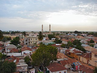
Banjul, officially the City of Banjul, is the capital and fourth largest city of The Gambia. It is the centre of the eponymous administrative division which is home to an estimated 400,000 residents, making it The Gambia's largest and most densely populated metropolitan area. Banjul is on St Mary's Island, where the Gambia River enters the Atlantic Ocean. The population of the city proper is 31,301, with the Greater Banjul Area, which includes the City of Banjul and the Kanifing Municipal Council, at a population of 413,397. The island is connected to the mainland to the west and the rest of Greater Banjul Area via bridges. There are also ferries linking Banjul to the mainland at the other side of the river.

The Gambia is a very small and narrow African country with the border based on the Gambia River. The country is less than 48 kilometres (30 mi) wide at its greatest width. The country's present boundaries were defined in 1889 after an agreement between the United Kingdom and France. It is often claimed by Gambians that the distance of the borders from the Gambia River corresponds to the area that British naval cannon of the time could reach from the river's channel. However, there is no historical evidence to support the story, and the border was actually delineated using careful surveying methods by the Franco-British boundary commission. The Gambia is almost an enclave of Senegal and is the smallest country on mainland Africa.

Serekunda is the largest urban centre in The Gambia. It is situated close to the Atlantic coast, 13 km (8 mi) south-west of the capital, Banjul, and is formed of nine villages which have grown together into a larger urban area.

Basse Santa Su, usually known as Basse, is a town in the Gambia, lying on the south bank of the River Gambia. The easternmost major town in the nation, it known for its important market. Basse is the capital of the Upper River Division, which is coterminous with the Basse Local Government Area. As of 2009, the town has an estimated population of 18,414. According to the 2013 census, the Basse LGA has 243,791 residents.

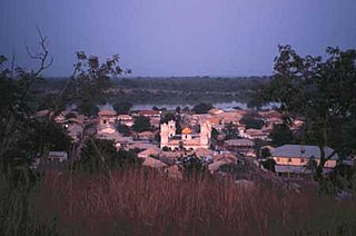
Jufureh is a town in the Gambia, 30 kilometers inland on the north bank of the River Gambia in the North Bank Division near James Island. The town is home to a museum and Fort Jillifree.

Central River is the largest of the five administrative divisions of the Gambia. Its capital is Janjanbureh, on MacCarthy Island. The largest settlement is Bansang, with an estimated population in 2008 of 8,381.

Upper River was one of the five Divisions of the Gambia. Its capital was Basse Santa Su. It was subsequently reorganised as the Basse Local Government Area, without any change in the area covered.
Bansang is a town in the Central River Division of the Gambia, with a population of 8,843 (2012). Although the official government center of the Division is located in Janjanbureh downstream, Bansang has better access to the more affluent coastal region of the country, and is sometimes considered the unofficial "upcountry" economic capital.
Kuntaur is a town located in central part of the Gambia.
Kombo East is one of the nine districts of the Gambia's Western Division, which is located to the south of the Gambia River in the southwest of the country. Kombo East is in the central south of the division, between Kombo Central and Foni Brefet.

Niamina Dankunku is one of the ten districts of the Central River Division of the Gambia.
Niani District is one of the ten districts of the Central River Division of the Gambia. It is named after the Kingdom of Niani, a pre-colonial Mandinka state.
Nianija is one of the ten districts of the Central River Division of the Gambia. In the 2013 census, it had a population of 10,175.
Sami District is one of the districts of the Central River Division of the Gambia. In the 2013 census, it had a population of 24,429.

Wuli District was one of the four districts of the former Upper River Division of the Gambia. The Upper River Division is now the Basse Local Government Area. Wuli was established as a parliamentary constituency in 1962 and was divided into Wuli West District and Wuli East District in 1987. The name derives from the historical region and former Mandinka kingdom of Wuli.
The Daily Observer is a newspaper published in Bakau in Banjul, the Gambia.
Aksy is a district of Jalal-Abad Region in western Kyrgyzstan. The seat lies at Kerben. Its area is 4,578 km2 (1,768 sq mi), and its resident population was 137,103 in 2021.
Dobo Forest Park is a forest park in the Gambia. Established on January 1, 1954, it covers 732 hectares.

