
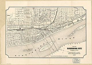
Harrisburg is the capital city of the Commonwealth of Pennsylvania, United States, and the seat of Dauphin County. With a population of 50,135 as of 2021, Harrisburg is the ninth-most populous city in Pennsylvania.

Columbia, formerly Wright's Ferry, is a borough (town) in Lancaster County, Pennsylvania, United States. As of the 2020 census, it had a population of 10,222. It is 28 miles (45 km) southeast of Harrisburg, on the east (left) bank of the Susquehanna River, across from Wrightsville and York County and just south of U.S. Route 30.

Interstate 83 (I-83) is an Interstate Highway located in the states of Maryland and Pennsylvania in the Eastern United States. Its southern terminus is at a signalized intersection with Fayette Street in Baltimore, Maryland; its northern terminus is at I-81 near Harrisburg, Pennsylvania. I-83 runs from Downtown Baltimore north to I-695 near the northern suburb of Timonium on the Jones Falls Expressway before forming a concurrency with I-695. After splitting from I-695, the route follows the Baltimore–Harrisburg Expressway north to the border between Maryland and Pennsylvania. Upon crossing the state line, I-83 becomes the Veterans of Foreign Wars of the United States Memorial Highway and continues north through York toward the Harrisburg area. The route runs along the southern and eastern portion of the Capital Beltway that encircles Harrisburg before reaching its northern terminus.

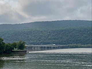
The Susquehanna River is a major river located in the Mid-Atlantic region of the United States, overlapping between the lower Northeast. At 444 miles (715 km) long, it is the longest river on the East Coast of the United States. By watershed area, it is the 16th-largest river in the United States, and also the longest river in the early 21st-century continental United States without commercial boat traffic.

Keystone Lake is a reservoir in northeastern Oklahoma on the Arkansas and Cimarron rivers. It is located upstream about 23 miles (37 km) from Tulsa. It was created in 1968 when the Keystone Dam was completed. The primary purposes are: flood control, hydroelectric power generation, wildlife management and recreation.

Raystown Lake is a reservoir in Huntingdon County, Pennsylvania. It is the largest lake that is entirely within Pennsylvania. The original lake was built by the Simpson family of Huntingdon as a hydroelectric project. The current 8,300-acre (34 km2) Raystown Lake was completed in 1973 by the Army Corps of Engineers. Raystown is around 200 feet (61 m) deep in the deepest area near the dam. The lake was created primarily to control floods, provide electricity, and support recreational activities. Allegheny Electric Cooperative operates the Raystown Hydroelectric Project and William F. Matson Generating Station at the Raystown Dam, a 21 MW, two-unit hydroelectric project.

The Philadelphia & Reading Railroad Bridge carries Norfolk Southern rail lines across the Susquehanna River between Lemoyne, Pennsylvania and Harrisburg, Pennsylvania. Some of its concrete piers encase stone masonry piers from an earlier truss bridge on this site, completed in 1891 by the Philadelphia, Harrisburg and Pittsburgh Railroad, which was then acquired by the Philadelphia and Reading Railroad to connect its Harrisburg and Lurgan lines. The current structure was constructed from 1920 to 1924 by replacing the trusses with concrete arches one track at a time. The bridge has fifty-one concrete arches, three more than the nearby Rockville Bridge.

Shipoke (SHY-poke) is a neighborhood in Harrisburg, Pennsylvania. Shipoke is delineated by I-83 to the south, Washington Street to the north, Second Street to the east, and the Susquehanna River to the west. It is Harrisburg Ward number one. Compared to the area of Harrisburg's other neighborhoods, Shipoke is small.

Harveys Creek is a tributary of the Susquehanna River in Luzerne County, Pennsylvania, in the United States. It is approximately 14.5 miles (23.3 km) long and flows through Harveys Lake, Lake Township, Lehman Township, Jackson Township, and Plymouth Township. The creek's watershed has an area of 46.3 square miles (120 km2). The creek has four named tributaries, which are known as Bear Hollow Creek, Paint Spring Run, Pikes Creek, and East Fork Harveys Creek. The watershed is designated as a High-Quality Coldwater Fishery and a Migratory Fishery above Pikes Creek and as a Coldwater Fishery and a Migratory Fishery below it. The creek's source is Harveys Lake, the largest natural lake in Pennsylvania.
Crooked Creek is a 26.3-mile-long (42.3 km) tributary of the Tioga River located entirely in Tioga County, Pennsylvania in the United States.
The Clarks Ferry Bridge is a plate girder bridge that carries U.S. Routes 22 and 322 across the Susquehanna River near Duncannon, Pennsylvania, about 20 miles north of Harrisburg, Pennsylvania. It is a 4 lane expressway standard bridge. The bridge also provides safe passage for hikers, bikers, and pedestrians using the Appalachian Trail and BicyclePA Route J. It was completed in November 1986 replacing a 1925 concrete arch toll bridge.

The Mid-Atlantic United States flood of 2006 was a significant flood that affected much of the Mid-Atlantic region of the eastern United States. The flooding was very widespread, affecting numerous rivers, lakes and communities from Upstate New York to North Carolina. It was widely considered to be the worst flooding in the region since Hurricane David in 1979. It was also one of the worst floodings in the United States since Hurricane Katrina in August 2005. At least 16 deaths were related to the flooding.

Little Pine State Park is a Pennsylvania state park on 2,158 acres (873 ha) in Cummings Township, Lycoming County, Pennsylvania in the United States. Little Pine State park is along 4.2 miles (6.8 km) of Little Pine Creek, a tributary of Pine Creek, in the midst of the Tiadaghton State Forest. A dam on the creek has created a lake covering 94 acres (38 ha) for fishing, boating, and swimming. The park is on Pennsylvania Route 4001, 4 miles (6.4 km) northeast of the unincorporated village of Waterville or 8 miles (13 km) southwest of the village of English Center. The nearest borough is Jersey Shore, Pennsylvania, about 15 miles (24 km) south at the mouth of Pine Creek on the West Branch Susquehanna River.

The geography of Pennsylvania varies from sea level marine estuary to mountainous plateau. The state is known for its natural resources, ports, and the leading role it played in the nation's founding and history.

Shikellamy State Park is a 132-acre (53 ha) Pennsylvania state park located at the confluence of the West Branch Susquehanna River and Susquehanna River in Pennsylvania. The park is divided into two sections. The older part, on a bluff on the western bank of the Susquehanna River, is the 78-acre (32 ha) Shikellamy overlook in Union Township, Union County. The newer part is the 54-acre (22 ha) marina on the southern end of Packer Island in Upper Augusta Township, Northumberland County. Packer's Island lies between the city of Sunbury and the borough of Northumberland at the confluence of the two branches of the river.

Paxton Creek is a 13.9-mile-long (22.4 km) tributary of the Susquehanna River in Dauphin County, Pennsylvania in the United States.
This is a timeline of the major events in the history of Harrisburg, Pennsylvania and vicinity.

Spring Brook is a tributary of the Lackawanna River in Lackawanna County and Luzerne County, in Pennsylvania, in the United States. It is approximately 17 miles (27 km) long and flows through Covington Township, Spring Brook Township, and Moosic in Lackawanna County and Pittston Township in Luzerne County. The watershed of the stream has an area of 57.2 square miles (148 km2). It is designated as a High-Quality Coldwater Fishery and a Migratory Fishery above Interstate 476 and as a Coldwater Fishery and a Migratory Fishery below it. A section is also designated as Class A Wild Trout Waters. The stream's tributaries include Panther Creek, Plank Bridge Creek, Rattlesnake Creek, Green Run, Monument Creek, and Covey Swamp Creek. It has a relatively high level of water quality and is very slightly acidic, with a pH of 6.4 to 6.9.

Leggetts Creek is a tributary of the Lackawanna River in Lackawanna County, Pennsylvania, in the United States. It is approximately 9.0 miles (14.5 km) long and flows through Scott Township, South Abington Township, and Scranton. The watershed of the creek has an area of 18.5 square miles (48 km2). The creek has three named tributaries: Leach Creek, Clover Hill Creek, and Summit Lake Creek. Leggetts Creek is considered to be impaired due to urban development problems, but is not affected by acid mine drainage. The creek is fairly alkaline and is a perennial stream. Its headwaters are in wetlands outside of the Lackawanna Valley and it flows through a water gap known as Leggetts Gap or The Notch. Major lakes in the watershed include the Griffin Reservoir, Summit Lake, and Maple Lake. The creek is a source of flooding in South Abington Township.
The Williamsport Dam, officially known as the Hepburn Street Dam, is a low-head dam on the West Branch Susquehanna River in Williamsport, Pennsylvania. It broke ground in 1984 and was finished in the spring of 1986. It was built for recreation, such as boating, watersports and fishing. It has been described as a "killer dam" and a "drowning machine".
