
Gelderland, also known as Guelders in English, is a province of the Netherlands, occupying the centre-east of the country. With a total area of 5,136 km2 (1,983 sq mi) of which 173 km2 (67 sq mi) is water, it is the largest province of the Netherlands by land area, and second by total area. Gelderland shares borders with six other provinces and the German state of North Rhine-Westphalia.

Zutphen is a city and municipality located in the province of Gelderland, Netherlands. It lies some 30 km northeast of Arnhem, on the eastern bank of the river Ijssel at the point where it is joined by the Berkel. First mentioned in the 11th century, the place-name appears to mean "south fen". In 2005, the municipality of Zutphen was merged with the municipality of Warnsveld, retaining its name. In 2019, the municipality had a population of 47,609.

The IJssel is a Dutch distributary of the river Rhine that flows northward and ultimately discharges into the IJsselmeer, a North Sea natural harbour. It more immediately flows into the east-south channel around the Flevopolder, Flevoland which is kept at 3 metres below sea level. This body of water is then pumped up into the IJsselmeer.

Deventer is a city and municipality in the Salland historical region of the province of Overijssel, Netherlands. In 2020, Deventer had a population of 100,913. The city is largely situated on the east bank of the river IJssel, but it also has a small part of its territory on the west bank. It is situated about 14 km north east of Apeldoorn, 50 km west of Enschede and 28 km south of Zwolle. In 2005 the municipality of Bathmen was merged with Deventer as part of a national effort to reduce bureaucracy in the country.

Hengelo is a city in the eastern part of the Netherlands, in the province of Overijssel. The city lies along the motorways A1/E30 and A35 and it has a station for the international Amsterdam – Hannover – Berlin service.

Kampen is a city and municipality in the province of Overijssel, Netherlands. A member of the former Hanseatic League, it is located at the lower reaches of the river IJssel.

Doesburg is a municipality and a city in the eastern Netherlands in the province of Gelderland. Doesburg received city rights in 1237 and had a population of 11,148 in 2019. The city is situated on the right bank of river IJssel, at the confluence of river Oude IJssel. The municipality of Doesburg is part of the Arnhem-Nijmegen agglomeration region.
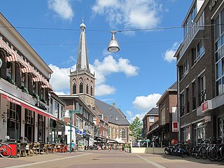
Doetinchem is a city and municipality in the east of the Netherlands. It is situated along the Oude IJssel river in a part of the province of Gelderland called the Achterhoek. The municipality had a population of 57,555 in 2019 and consists of an area of 79.66 km2 (30.76 sq mi) of which 0.61 km2 (0.24 sq mi) is water. This makes Doetinchem the largest town in the Achterhoek.
Capelle aan den IJssel is a small city and municipality in the western Netherlands, in the province of South Holland. The municipality had a population of 66,818 in 2019, and covers an area of 15.40 km2 (5.95 sq mi), of which 1.26 km2 (0.49 sq mi) is water. It is situated on the eastern edge of Rotterdam, on the Hollandse IJssel river.

Terborg is a small city in the Dutch province of Gelderland, in the Achterhoek region in the east of the Netherlands. It is located in the municipality of Oude IJsselstreek. The city lies about 7 km southeast of Doetinchem. The population is about 4600 inhabitants.

The Achterhoek is a cultural region in the Eastern Netherlands. Its name is geographically appropriate because the area lies in the easternmost part of the province of Gelderland and therefore in the east of the Netherlands, protruding into Germany. The Achterhoek lies at the east of the IJssel and Oude IJssel rivers. On the other sides, it borders Germany to the southeast and the province of Overijssel to the northeast.

Oude IJsselstreek is a municipality in the eastern Netherlands. It was established on 1 January 2005 through a merger of the former municipalities Gendringen and Wisch.

The Oude IJssel or Issel is a river in Germany and the Netherlands approximately 82 km (51 mi) long. It is a right tributary of the river IJssel. Oude IJssel is Dutch for "Old IJssel"; the Oude IJssel was the upper course of the IJssel until the connection with the Rhine was dug, possibly in the Roman era.
Etten is a village in the Dutch province of Gelderland. It is located in the municipality of Oude IJsselstreek, 7 km southeast of Doetinchem.

Ulft is a town in Oude IJsselstreek in the Achterhoek area in the province of Gelderland, Netherlands.

The Meuse-Rhine-Issel or Meuse-Rhine-Yssel is a Dutch breed of dual-purpose cattle, reared both for meat and for milk. It falls within the Lowland-Pied group of North European cattle; it is red-pied, and of medium-large size.

Amsterdam-Centrum is the inner-most borough and historical city centre of Amsterdam, Netherlands containing the majority of the city's landmarks. Established in 2002, Amsterdam-Centrum was the last area in the city to be granted the status of self-governing borough. The borough is only 8.04 km2 large and covers the old innercity and the UNESCO-listed Amsterdam canal belt. In 2013, the borough had approximately 85,000 inhabitants, who on average had the second-highest income per household in the city and one of the highest in the country.

Kloveniersburgwal is an Amsterdam canal flowing south from Nieuwmarkt to the Amstel River on the edge of the medieval city, lying east of the dam in the centre of Amsterdam.
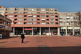
Overstegen is a district in the north-east of Doetinchem, the biggest city within the Gelderse Achterhoek. Typical for this district is the many apartment buildings found by the Caenstraat and around the mall. Apart from a mall, a care facility, Het Trommelslag, is found within. The district was built in the 1960s and 1970s.
De Huet is a suburban district near the city of Doetinchem, mostly built in the 1980s and 1990s. The district is located south-west of the city centre, and south of the Oude IJssel river.