
Albany is a port city in the Great Southern region in the Australian state of Western Australia, 418 kilometres (260 mi) southeast of Perth, the state capital. The city centre is at the northern edge of Princess Royal Harbour, which is a part of King George Sound. The central business district is bounded by Mount Clarence to the east and Mount Melville to the west. The city is in the local government area of the City of Albany. While it is the oldest colonial, although not European, settlement in Western Australia — predating Perth and Fremantle by over two years — it was a semi-exclave of New South Wales for over four years until it was made part of the Swan River Colony.

Albany Highway links Western Australia's capital city Perth with its oldest settlement, Albany, on the state's south coast. The 405-kilometre-long (252 mi) highway travels through the southern Wheatbelt and Great Southern regions, and is designated State Route 30 for most of its length. Outside of Perth the highway is predominately a sealed, single carriageway with regular overtaking lanes in some undulating areas. Albany Highway commences at The Causeway, a river crossing that connects to Perth's central business district. The highway heads south-east through Perth's metropolitan region, bypassed in part by Shepperton Road and Kenwick Link, and continues south-eastwards through to Albany. It intersects several major roads in Perth, including the Leach, Tonkin, Brookton, and South Western highways. The rural section of Albany Highway connects to important regional roads at the few towns and roadhouses along the route, including Coalfields Highway at Arthur River, Great Southern Highway at Cranbrook, and Muirs Highway at Mount Barker.

The Shire of Plantagenet is a local government area in the Great Southern region of Western Australia, managed from the town of Mount Barker, 360 kilometres (224 mi) south of Perth and 50 kilometres (31 mi) north of Albany. The shire covers an area of 4,792 square kilometres (1,850 sq mi) and includes the communities of Narrikup, Rocky Gully, Kendenup and Porongurup.

Watsons Bay is a harbourside, eastern suburb of Sydney, in the state of New South Wales, Australia. Watsons Bay is located 11 km north-east of the Sydney central business district, in the local government area of the Municipality of Woollahra.

Albany wind and Grasmere farms are two wind power stations near Albany, Western Australia, owned by Bright Energy Investments. They are adjacent and are often considered a single facility. They have 18 wind turbines, with a maximum generating capacity of 35.4 MW of electricity. The original Albany Wind Farm was commissioned in October 2001, after ten years of planning. The wind farm has the capacity to produce 80 per cent of the electricity requirements of Albany.

The City of Albany is a local government area in the Great Southern region of Western Australia, about 410 kilometres (255 mi) south-southeast of Perth, the capital of Western Australia. It covers an area of 4,312.3 square kilometres (1,665 sq mi), including the Greater Albany metropolitan area and the Port of Albany, as well as the surrounding agricultural district and some national parks. The City of Albany had a population of over 36,000 at the 2016 census.
Centennial Park is an inner suburb of Albany, Western Australia, immediately north of the CBD within the local government area of the City of Albany. It contains a light industrial area and numerous sporting facilities which serve the entire Albany catchment area.

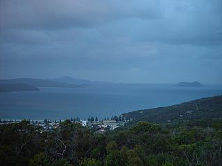
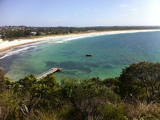
Binalup/Middleton Beach is a coastal suburb of Albany, Western Australia, located within the City of Albany approximately 4 kilometres (2.5 mi) east of the city centre. The traditional owners, the Noongar peoples, know the place as Binalup meaning the place of first light since the sun rises over the waters in the morning. The main road between the city and the locality is via Middleton Road. It is home to a caravan park and numerous holiday units which provide accommodation for visitors to the Albany region.
Mount Clarence is an inner suburb of Albany, Western Australia, between the Albany city centre and Middleton Beach. Its local government area is the City of Albany, and over three-quarters of its land area is either parkland or forest, including Albany's Heritage Park. Mount Clarence was gazetted as a suburb in 1979.
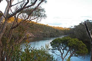
The Kalgan River is a river in the Great Southern region of Western Australia.
Tourist Drives in Western Australia are routes through areas of scenic or historic significance, designated by route markers with white numbers on a brown shield. Tourist Drives were introduced into Western Australia while Eric Charlton was the state government Minister for Transport in the 1990s. The 28 numbered routes collectively traverse more than 2,000 kilometres (1,200 mi) across the state. In addition to the Tourist Drives, there are unnumbered routes such as the Golden Pipeline Heritage Trail, and local governments may designate and maintain local scenic drives, generally unnamed and unnumbered.

The Esplanade Hotel was a hotel that once stood overlooking Middleton Beach in Albany, Western Australia. The hotel was demolished in January 2007 by Singaporean owners, WCP Plaza, to make way for an 81-room hotel, function centre, village square, shops and health and recreation facilities. The proposal for the new hotel was approved in 2007 by the City of Albany. The council also supported the rezoning of several locations in Earl Street and Barry Court to allow the development of the hotel. The site remains vacant in 2015.

Pyrmont, also referred to as Pyrmont House, is a residence located on Serpentine Road in Albany in the Great Southern region of Western Australia. It is one of the oldest buildings in Albany.
Middleton Beach shark barrier, also referred to as the Albany shark barrier and the Ellen Cove shark barrier, is a shark barrier to prevent sharks entering the main swimming area at Ellen Cove at the southern end of Middleton Beach, a popular swimming beach in Albany in the Great Southern region of Western Australia.

Stirling Terrace, Albany is a street in the centre of Albany, Western Australia adjoining York Street.

Ellen Cove Jetty also known as Middleton Beach Jetty is a jetty found at the southern end of Middleton Beach in King George Sound in Albany in the Great Southern region of Western Australia.

Alison Hartman Garden, often referred to as Mokare Park, is a park on York Street in Albany in the Great Southern region of Western Australia.

The Eyre Park is a park in Middleton Beach in Albany in the Great Southern region of Western Australia.
Middleton Road is a significant arterial road in Albany, Western Australia.

