
Saguaro Lake is the fourth reservoir on the Salt River, formed by the Stewart Mountain Dam in the U.S. state of Arizona. The lake is off State Route 87, about halfway between Phoenix and the ghost town of Sunflower. The dammed end of the lake is at 33.5656°N 111.5361°W, at an elevation of 1,506 feet (459 m).

Lynx Lake, Arizona, is a 55-acre (220,000 m2) reservoir located within Prescott National Forest, approximately 5 miles (8.0 km) east of Prescott, Arizona, in the Bradshaw Mountains. The lake is located at 5,530 feet (1,690 m) elevation and is stocked for fishing. It is one of the most popular recreation areas in central Arizona. Mild weather, the cool ponderosa pine forest, trout fishing, boating, mountain hiking, horseback riding, archaeological sites, and bird watching attract visitors from throughout Arizona. The lake was formed in 1952, when a dam was put in Lynx Creek, 6 miles (9.7 km) below Walker, Arizona.
Goldwater Lake is a reservoir formed by a dam on Banning Creek, located south of Prescott in North Central Arizona. This lake is maintained by the City of Prescott Parks and Recreation Department. The park has facilities for picnicking, fishing, boating, hiking, volleyball, and horseshoes.

Chevelon Canyon Lake is a small reservoir located in northern Arizona, about 28 mi (45 km) northwest of the town of Heber. It is one in a series of small, canyon-bound lakes located on the Mogollon Rim, collectively referred to as the Rim Lakes. It is said to be among the most difficult to access in the region. It is also the second reservoir on Chevelon Creek, downstream from Woods Canyon Lake. The facilities are maintained by Apache–Sitgreaves National Forests division of the USDA Forest Service.
Woods Canyon Lake is a small lake located in northern Arizona, United States, about 30 mi (48 km) east of the city of Payson. It is one in a series of small, canyon-bound lakes located on the Mogollon Rim, collectively referred to as the Rim Lakes. It is among the more developed and accessible of the Rim Lakes. It is also the first reservoir on Chevelon Creek, upstream from Chevelon Canyon Lake.
Clear Creek Reservoir is located in the town of Winslow, Arizona, which is in Navajo County. It is fed by Clear Creek and drains to the Little Colorado River.
Becker Lake is a reservoir managed as a trophy trout lake. Located near Springerville, Arizona, Becker Lake is part of the 622-acre (252 ha) Becker Lake Wildlife Area. Built around the year 1880, it is one of the oldest reservoirs in the White Mountains. The Arizona Game and Fish Department acquired the lake and property around it in 1973. The lake is located at 6,910 feet (2,110 m).

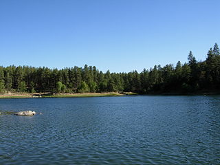
Blue Ridge Reservoir is located in the Mogollon Rim area of the state of Arizona. Clint Wells, Arizona. Blue Ridge Reservoir is one of the more scenic reservoirs in the area, with trees going down to the water line. The facilities are maintained by Coconino National Forest division of the USDA Forest Service.
Bunch Reservoir is one of a trio of lakes on the Little Colorado River that provides trout fishing opportunities in and around the town of Greer.
Nelson Reservoir is a reservoir located in Apache County, Arizona between Springerville and Alpine. The Reservoir is a long and narrow lake which follows the Nutrioso Creek Valley for nearly a mile. Fish that remain in Nelson Reservoir after summer stockings can grow to good size, making it a popular fishing site with local anglers.
Built in 1896 on the Little Colorado River, River Reservoir is the largest and deepest of a trio of lakes collectively known as the Greer Lakes. Drained since 2004 because of safety issues, the dam at River Reservoir was repaired in 2005. Like the other two Greer Lakes, it has new amenities. River Reservoir is located at 8,220 feet (2,510 m) on the Apache-Sitgreaves National Forests.
Coconino Reservoir is located near Flagstaff in North Central Arizona and is just half mile south of Ashurst Lake. Recreational facilities are maintained under the authority of the Coconino National Forest.
Tunnel Reservoir is an artificial lake and recreational area located in the White Mountains around the town of Greer, Arizona. This reservoir is one of three lakes known as the Greer Lakes. The Greer Lakes include Bunch, Tunnel and River Reservoirs, and are a short distance apart from each other. The boating facility offers a boat launching area, boat trailer parking, restrooms, and space for recreational vehicles. The reservoir is stocked with Rainbow and Brown trout species.
Fain Lake is a reservoir located near Prescott Valley in Yavapai County, North Central Arizona.
Santa Fe Lake is the name of two waterbodies: a reservoir in 0.5 mi (0.80 km) south of downtown Williams in North Central Arizona, and a natural lake in the southern Sangre de Cristo Mountains near Ski Santa Fe in Santa Fe County, New Mexico. The reservoir is behind Santa Fe Dam, built in red sandstone. It is named after the Atchison, Topeka, and Santa Fe Railway, which stored the reservoir's water for its steam locomotives traveling through Williams. The natural lake is formed by snowmelt from Tesuque Peak and Lake Peak. It was named after the nearby state capital of Santa Fe, New Mexico, which was founded in 1610 as the capital of the Spanish province of Santa Fe de Nuevo México.
Frye Mesa Reservoir is located in southeastern Arizona, 15 miles (24 km) southwest of Safford in the Coronado National Forest.

Patagonia Lake is a man-made reservoir in Santa Cruz County, Arizona, United States, located southwest of the town of Patagonia, Arizona and northeast of Nogales. The lake was created by damming Sonoita Creek, and is a popular area for boating and sport fishing. Facilities are maintained by Arizona State Parks as part of Patagonia Lake State Park.
Riggs Flat Lake is a reservoir located near the top of the Pinaleño Mountains, in the Coronado National Forest and Graham County, Arizona.

Roper Lake State Park is a state park of Arizona, surrounding 32-acre (130,000 m2) Roper Lake. The park is located off U.S. Route 191, 5 miles (8.0 km) south of Safford, at the Gila River and Valley.
Lee Valley Lake is Arizona's highest elevation reservoir, situated at 9,420 feet (2,870 m) in the Apache-Sitgreaves National Forests near Mount Baldy. It is located approximately 35 miles from Pinetop-Lakeside, connected by Arizona highways 260 and 273 and forest road 113. Access is restricted in the winter when roads are closed due to snow, generally December to early April.
