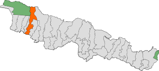
Bara District is one of the seventy–seven districts of Nepal, located in the western part of the Madhesh Province. The district is third richest district in Nepal after Kathmandu and Morang with 3.3% share of total GDP of Nepal and highest per capita income in Madhesh province. Kalaiya serves as the district's headquarter. Bakaiya, Jamuniya, Pasaha, Dudhaura and Bangari are the main rivers of Bara. The main languages spoken in the district are Bhojpuri, Tharu, Bajjika, and Nepali.
Narayansthan is a village development committee in Baglung District in the Dhaulagiri Zone of central Nepal.It is located above the bank of Kali gandaki River. Now, it has become one of the major important place in baglung. They have planned to construct the domestic Airport. At the time of the 2011 Nepal census it had a population of 2,876 and had 781 houses in the town. The major castes living in the VDC are Brahman, Chhetry and Newar. There are 2 high schools - Janatadhan Higher School and Ganesh Secondary School and one campus. Krishna Gandaki Campus is at the premises of Janatadhan HSS. Ganesh Secondary School, one of the best schools in the region is known for its quality education movement. Established in 1957 [2014 BS] by Soldier Board (India), Ganesh Secondary School is one of the oldest schools. In 1964 [2021 BS], the Indian Soldier Board stopped its grant. Since there was no school support mechanism developed from the Government of Nepal, the school passed through many ups and downs. After Modern Education Act came in effect in 1971 BS [2028 BS], the school merged with Janatadhan Higher Secondary School. In 1980 [2037 BS], the school was reopened.
Borlang is a village development committee in northern-central Nepal. As of the 1991 Nepal census it had a population of 4,737 and had 837 houses.
Amlekhganj (Nepali:अमलेखगंज) is a town and Village Development Committee in Bara District in the Narayani Zone of south-eastern Nepal. At the time of the 2011 Nepal census it had a population of 6,709 people living in 1370 individual households. There were 3,413 males and 3,296 females at the time of census. At one time it was famed as the starting point of the Nepal Government Railway (NGR) which connected it with Raxaul in India.
Baghawan ward no 14, sub-metropolitan Kalaiya Bara, Nepal.
Basatpur is a town and was Village Development Committee in Bara District in the Narayani Zone of south-eastern Nepal. According to new geographical updates in Nepal, Basatpur now falls under Kalaiya Sub-Metropolitan City and has been defined as Kalaiya-20 where 20 is a ward number in Kalaiya. It is now Basatpur in Bara District, Kalaiya Sub-Metropolitan City, Province Number 2, NEPAL. It's no longer Village Development Committee. The capital of the district is Kalaiya which is around 10 km north of Basatpur, Matiarwa lies west of Basatpur which is another town in the Kalaiya Sub-Metropolitan City. Adapur lies to the south of Basatpur which is a small town next to Basatpur in India. Basatpur is one of the biggest town and populated town in Kalaiya, Bara. To the south of Basatpur, it has open border of India which is just 1-2 km far from the town. It has plain areas and very fertile lands to grow crops. It is a popular town in the neighboring areas which is famous for its markets, ponds, temples, and culture. The majority of person living in the town are Hinduism and then Muslims. At the time of the 1991 Nepal census it had a population of 4,435 persons residing in 740 individual households.
Dumarwana is a town in Jeetpursimara Sub-metropolitan City in Bara District in the Narayani Zone of south-eastern Nepal. The formerly Village Development Committee was merged to form new municipality since 18 May 2014. At the time of the 2011 Nepal census it had a population of 21,470 persons living in 4,416 individual households. There were 10,228 males and 11,242 females at the time of census.
Inarwasira is a ward of Jeetpursimara sub-metropolitan city in Bara District in the Narayani Zone of south-eastern Nepal. At the time of the 1991 Nepal census, it had a population of 8,588. But now from 2017 election, its population has increased. Now, the population is 15,000 in this ward. It is an important ward of the Jeetpursimara metropolitan city. In this ward some banks like Sana Kishan bank, some saving banks and Exchanges are also have been established. It has a higher secondary school. It has a global road to reach Kalaiya & Jeetpur. The Road is named as Hulaki Marg and is under construction process. The most important thing in this village is a market, called "Inarwa Bazar" and is famous around the area. As a whole, the village is growing day by day.

Gadhimai is a former independent municipality in Bara District in of south-eastern Nepal that was merged into Jeetpur Simara Sub-Metropolitan City on 10 March 2017. It was itself established on 18 May 2014 by merging Pipara Simara, Jitpur Bhawanipur, Chhata Pipra, Phattepur, Dumbarwana Village Development Committees.
Motisar is a village and Village Development Committee in Bara District in the Narayani Zone of south-eastern Nepal. At the time of the 1991 Nepal census it had a population of 2,633 persons living in 399 individual households. The village is situated between Kalaiya and Birgunj City.

Nijgadh, is a town and municipality in Nepal, located in Bara District of the Madhesh Province. The total area of the municipality is 289.4 sq. km. The municipality was formed on 8 May 2014 by merging Nijgadh VDC with Ratnapuri VDC and Bharatganj Singaul VDC.

Simara is a rapidly growing city in Jitpursimara sub-metropolitan city in Bara District in Province No. 2 of south-eastern Nepal. The formerly Village Development Committee was merged to form a new municipality Gadhimai Municipality on 18 May 2014. Similarly, on 10 March 2017 Gadhimai Municipality, Inarwasira, Amlekhganj, as well as parts of Manharwa, Haraiya and Rampur Tokani were merged to form new Jitpursimara sub-metropolitan city. Aauraha, Panitanki, Ramban, Narbasti, Bajani, Purwatol etc are the villages in Simara. Auraha and Purwatol lie in the east, Bajani in the south, Hulas in north and Ramban & Narbasti in the west. At the time of the 2011 Nepal census it had a population of 23,835 people living in 5,253 individual households. But population have increased dramatically in last decade with real state boom and rising numbers of new business in the city so the current population might be estimated as high 40,000 according to local journals.
Tedhakattiटेढाकट्टी is a village and Village Development Committee in Bara District in the Narayani Zone of south-eastern Nepal. At the time of the 2011 Nepal census it had a population of 4623 people living in 476 individual households. According to the census 2011 it has population of more than 4683.

Kalaiya is a sub-metropolitan city and serves as the headquarters of Bara District in Madhesh Province, Nepal. At the time of the 2021 Nepal census, it had a population of 141,179 people residing in 28,645 individual households.

Manthali is a municipality and the headquarters of Ramechhap District in Bagmati Province, Nepal that was established on 2 December 2014 by merging the former village development committees Old-Manthali, Bhatauli, Chisapani, Kathjor, Bhaluwajor, Salupati and Sunarpani. It was declared the headquarters of the district on 9 March 1989. It lies on the bank of the Tamakoshi River. At the time of the 2011 Nepal census, it had a population of 45,416 people, living in 10,099 individual households.
Pipariya is a village development committee in Sarlahi District in the Janakpur Zone of south-eastern Nepal. At present it's part of Kabilasi Municipality. It includes 2 wards of Kabilasi i.e. 1&2. According to the CBS 2011 it is carrying 1,218 households and total population 6,991 including 3,581 males and 3,410 females.
Jitpursimara is a sub-metropolitan city in Bara District in Province No. 2 of southern Nepal that was formed on 10 March 2017 after merging Gadhimai Municipality, Inarwasira, Amlekhganj, as well as parts of Manharwa, Haraiya and Rampur Tokani to form a new sub-metropolitan city. At the time of the 2011 Nepal census, the former settlements that would make up the sub-metropolitan city had a joint population of 117,094 people living in 21,670 individual households.
Ghusel is a village and former Village Development Committee that is now part of Bagmati Rural Municipality in Bagmati Province of central Nepal. It is located southern part of Kathmandu Valley at similar or less heights. At the time of the 2011 Nepal census it had a population of 1510 in 308 individual households, down from the time of the 1991 Nepal census when it had a population of 1715 in 294 individual households.

Bara 3 is one of four parliamentary constituencies of Bara District in Nepal. This constituency came into existence on the Constituency Delimitation Commission (CDC) report submitted on 31 August 2017.

Bara 4 is one of four parliamentary constituencies of Bara District in Nepal. This constituency came into existence on the Constituency Delimitation Commission (CDC) report submitted on 31 August 2017.


