Related Research Articles
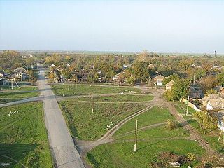
Ardon is a town and the administrative center of Ardonsky District in the Republic of North Ossetia-Alania, Russia, located in the center of the republic on the west bank of the Ardon River, 39 kilometers (24 mi) northwest of the republic's capital Vladikavkaz. As of the 2010 Census, its population was 18,774.

Belaya Kalitva is a town and the administrative center of Belokalitvinsky District in Rostov Oblast, Russia. Population: 43,651 (2010 Census); 47,347 (2002 Census); 47,803 (1989 Soviet census).

Ust-Labinsk is a town and the administrative center of Ust-Labinsky District of Krasnodar Krai, Russia.

Shovgenovsky District is an administrative and a municipal district (raion), one of the seven in the Republic of Adygea, Russia. It is located in the central northern portion of the republic and borders with Ust-Labinsky District of Krasnodar Krai in the north, Kurganinsky District of Krasnodar Krai in the north and northeast, Koshekhablsky District in the east and southeast, Giaginsky District in the south, Belorechensky District of Krasnodar Krai in the southwest, and with Krasnogvardeysky District in the west. The area of the district is 521.43 square kilometers (201.33 sq mi). Its administrative center is the rural locality of Khakurinokhabl. As of the 2010 Census, the total population of the district was 16,997, with the population of Khakurinokhabl accounting for 23.8% of that number.

Alagirsky District is an administrative and municipal district (raion), one of the eight in the Republic of North Ossetia–Alania, Russia. It is located in the central and southern parts of the republic along the Russian border with South Ossetia/Georgia. The area of the district is 2,135 square kilometers (824 sq mi). Its administrative center is the town of Alagir. Population: 38,830 (2010 Census); 38,581 ; 39,048 (1989 Soviet census). The population of Alagir accounts for 54.0% of the district's total population.
Mozdoksky District is an administrative and municipal district (raion), one of the eight in the Republic of North Ossetia–Alania, Russia. It is located in the north of the republic. The area of the district is 1,080 square kilometers (420 sq mi). Its administrative center is the town of Mozdok. Population: 84,682 (2010 Census); 88,634 ; 77,063 (1989 Soviet census). The population of Mozdok accounts for 45.8% of the district's total population.
Ardonsky District is an administrative and municipal district (raion), one of the eight in the Republic of North Ossetia–Alania, Russia. It is located in the center of the republic. The area of the district is 376.5 square kilometers (145.4 sq mi). Its administrative center is the town of Ardon. Population: 30,685 (2010 Census); 28,831 ; 22,725 (1989 Soviet census). The population of Ardon accounts for 61.2% of the district's total population.

Digorsky District is an administrative and municipal district (raion), one of the eight in the Republic of North Ossetia–Alania, Russia. It is located in the west of the republic. The area of the district is 640 square kilometers (250 sq mi). Its administrative center is the town of Digora. Population: 19,334 (2010 Census); 20,625 ; 19,328 (1989 Soviet census). The population of Digora accounts for 56.1% of the district's total population.

Irafsky District is an administrative and municipal district (raion), one of the eight in the Republic of North Ossetia–Alania, Russia. It is located in the west of the republic. The area of the district is 1,376 square kilometers (531 sq mi). Its administrative center is the rural locality of Chikola. Population: 15,766 (2010 Census); 15,708 ; 15,732 (1989 Soviet census). The population of Chikola accounts for 44.5% of the district's total population.

Kirovsky District is an administrative and municipal district (raion), one of the eight in the Republic of North Ossetia–Alania, Russia. It is located in the north of the republic. The area of the district is 411 square kilometers (159 sq mi). Its administrative center is the rural locality of Elkhotovo. Population: 27,807 (2010 Census); 26,571 ; 19,954 (1989 Soviet census). The population of Elkhotovo accounts for 45.4% of the district's total population.

Ust-Labinsky District is an administrative district (raion), one of the thirty-eight in Krasnodar Krai, Russia. As a municipal division, it is incorporated as Ust-Labinsky Municipal District. It is located in the center of the krai. The area of the district is 1,511 square kilometers (583 sq mi). Its administrative center is the town of Ust-Labinsk. Population: 112,900 (2010 Census); 115,442 (2002 Census); 100,770 (1989 Soviet census). The population of Ust-Labinsk accounts for 38.3% of the district's total population.

Belokalitvinsky District is an administrative and municipal district (raion), one of the forty-three in Rostov Oblast, Russia. It is located in the center of the oblast. The area of the district is 2,649.8 square kilometers (1,023.1 sq mi). Its administrative center is the town of Belaya Kalitva. Population: 102,039 ; 28,294 (2002 Census); 28,009 (1989 Soviet census). The population of Belaya Kalitva accounts for 42.8% of the district's total population.

Oktyabrsky District is an administrative and municipal district, (raion), one of the forty-three in Rostov Oblast, Russia. It is located in the western central part of the oblast. The area of the district is 1,998.7 square kilometers (771.7 sq mi). Its administrative center is the urban locality of Kamenolomni. Population: 73,224 ; 78,983 (2002 Census); 66,566 (1989 Soviet census). The population of Kamenolomni accounts for 15.4% of the district's total population.

Kasimovsky District is an administrative and municipal district (raion), one of the twenty-five in Ryazan Oblast, Russia. It is located in the north of the oblast. The area of the district is 2,969 square kilometers (1,146 sq mi). Its administrative center is the town of Kasimov. Population: 29,602 ; 35,365 (2002 Census); 41,422 (1989 Soviet census).

Alexandro-Nevsky District is an administrative and municipal district (raion), one of the 25 in Ryazan Oblast, Russia. It is located in the south of the oblast. The area of the district is 833 square kilometers (322 sq mi). Its administrative center is the urban locality of Alexandro-Nevsky. Population: 11,818 ; 13,071 (2002 Census); 13,547 (1989 Soviet census). The population of the administrative center accounts for 34.0% of the district's total population.

Novoduginsky District is an administrative and municipal district (raion), one of the twenty-five in Smolensk Oblast, Russia. It is located in the northeast of the oblast. The area of the district is 1,922.04 square kilometers (742.10 sq mi). Its administrative center is the rural locality of Novodugino. Population: 10,477 ; 11,860 (2002 Census); 14,240 (1989 Soviet census). The population of Novodugino accounts for 36.6% of the district's total population.
Leninsky District is an administrative district (raion), one of the twenty-three in Tula Oblast, Russia. It is located in the northern central part of the oblast. The area of the district is 1,351.21 square kilometers (521.71 sq mi). Its administrative center is the rural locality of Leninsky. Population: 63,355 ; 64,412 (2002 Census); 70,013 (1989 Soviet census). The population of the administrative center accounts for 11.1% of the district's total population.
Digora is a town and the administrative center of Digorsky District of the Republic of North Ossetia–Alania, Russia, located on the Ursdon River, 49 kilometers (30 mi) northwest of the republic's capital Vladikavkaz. As of the 2010 Census, its population was 10,856.
Chikola is a rural locality and the administrative center of Irafsky District of the Republic of North Ossetia–Alania, Russia. Population: 7,017 (2010 Census); 7,017 (2002 Census); 6,723 (1989 Soviet census).
References
- ↑ Согласно статье 23.1 закона «О статусе и границах муниципальных образований Архангельской области» Archived 2012-02-07 at the Wayback Machine наименование муниципального образования определяется в уставе муниципального образования и должно состоять из словосочетания «муниципальное образование» и собственного наименования муниципального образования
Notes
| | This Arkhangelsk Oblast location article is a stub. You can help Wikipedia by expanding it. |