Related Research Articles
The Dominion Land Survey is the method used to divide most of Western Canada into one-square-mile (2.6 km2) sections for agricultural and other purposes. It is based on the layout of the Public Land Survey System used in the United States, but has several differences. The DLS is the dominant survey method in the Prairie provinces, and it is also used in British Columbia along the Railway Belt, and in the Peace River Block in the northeast of the province.
In Canada, an Indian reserve or First Nations reserve is defined by the Indian Act as a "tract of land, the legal title to which is vested in Her Majesty, that has been set apart by Her Majesty for the use and benefit of a band." Reserves are areas set aside for First Nations, one of the major groupings of Indigenous peoples in Canada, after a contract with the Canadian state, and are not to be confused with Indigenous peoples' claims to ancestral lands under Aboriginal title.

Completed
The Peace River Block is a 3,500,000-acre (14,000 km2) area of land in northeastern British Columbia, in the Peace River Country. In exchange for building a rail line across Canada to British Columbia, the Canadian Pacific Railway was given the Railway Belt, 20 miles (32 km) of land on each side of the railway. To compensate the CPR for alienated or non-arable land in the 40-mile-wide (64 km) strip, the province allowed the Government of Canada to take control of 3,500,000 acres within B.C., northeast of the Rocky Mountains. This arrangement passed the provincial Legislature on December 19, 1883, and passed the Parliament of Canada on March 21, 1884, as the Settlement Act. All the land northeast of the Rocky Mountains became a provincial reserve pending the government of Canada's decision on what land to select, which prevented homesteading and land claims. After several surveys of the land the government took possession in 1907. The land the government chose was an approximately square-shaped block of land 72.4 miles (116.5 km) north-south and 75.7 miles (121.8 km) east-west. The south boundary begins at the intersection of the Alberta-British Columbia border and the Twentieth Baseline of the Dominion Land Survey, and the north boundary begins at the Twenty-third Baseline; however, both boundaries are run at right angles to the Alberta-British Columbia Border without accounting for meridian convergence and thus deviate south of each baseline. Land within the block was initially surveyed using the 3rd and 4th Systems of the Dominion Land Survey; however, much of the south and west parts of the block were eventually surveyed into district lots similar to other parts of British Columbia.
The Dominion Steel and Coal Corporation was a Canadian coal mining and steel manufacturing company. Incorporated in 1928 and operational by 1930, DOSCO was predated by the British Empire Steel Corporation (BESCO), which was a merger of the Dominion Coal Company, the Dominion Iron and Steel Company and the Nova Scotia Steel Company. DOSCO was one of the largest private employers in Canada during the 1930s–1950s. In 1957, DOSCO was purchased as a subsidiary of A.V. Roe Canada Ltd.
The Socialist Party of British Columbia (SPBC) was a provincial political party in British Columbia, Canada, from 1901 to 1905. In 1903, the SPBC won seats in the Legislative Assembly of British Columbia.
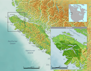
The Quatsino First Nation is the First Nations band government of the Gwat'sinux subgroup of the Kwakwaka'wakw peoples, based in the Quatsino Sound region on the west coast of northern Vancouver Island in British Columbia, Canada, focused on the community of Coal Harbour in Quatsino Sound. It is a member of the Kwakiutl District Council and, for treaty negotiation purposes, the Winalagalis Treaty Group which includes three other members of the Kwakiutl District Council (the Da'naxda'xw Awaetlatla Nation, Gwa'Sala-Nakwaxda'xw Nation, and the Tlatlasikwala Nation.

The Cadomin Formation is a stratigraphic unit of Early Cretaceous age in the western part of the Western Canada Sedimentary Basin. It is extends from southeastern British Columbia through western Alberta to northeastern British Columbia, and it contains significant reservoirs of natural gas in some areas. It was named after the mining town of Cadomin, which is an acronym of "Canadian Dominion Mining".
Land is owned in Canada by governments, Indigenous groups, corporations, and individuals. Canada is the second-largest country in the world by area; at 9,093,507 km2 or 3,511,085 mi2 of land. It occupies more than 6% of the Earth's surface.

Portland Island is an island of the Southern Gulf Islands of the South Coast of British Columbia, Canada. It is located in the Salish Sea west of Moresby Island and off the south tip of Saltspring Island, adjacent to the main BC Ferries route just offshore from the terminal at Swartz Bay at the tip of the Saanich Peninsula. It was named after HMS Portland, the flagship of Rear-Admiral Fairfax Moresby, Commander in Chief of the Pacific Station 1850–1853.

Watino is a hamlet in northern Alberta, Canada within Birch Hills County. It is located on Highway 49, approximately 96 kilometres (60 mi) northeast of Grande Prairie, and has an elevation of 385 meters (1,263 ft).
The East Kootenay is a large coal field located in the west of Canada in British Columbia. East Kootenay represents one of the largest coal reserve in Canada having estimated reserves of 8 billion tonnes of coal.
The Peace River is a large coal field located in the west of Canada in British Columbia. Peace River represents one of the largest coal reserve in Canada having estimated reserves of 4.9 billion tonnes of coal.
The Elkview Coal Mine is a coal mine located in the British Columbia. The mine has coal reserves amounting to 220.6 million tonnes of coking coal, one of the largest coal reserves in Canada and the world. The mine has an annual production capacity of 4.19 million tonnes of coal.
The Fording River Coal Mine is a coal mine located in British Columbia, Canada. The mine has coal reserves amounting to 263.8 million tonnes of coking coal, one of the largest coal reserves in Canada and the world. The mine has an annual production capacity of 8.34 million tonnes of coal.
The Crowsnest is a large coal field located in the west of Canada in British Columbia. Crowsnest represents one of the largest coal reserve in Canada having estimated reserves of 25 billion tonnes of coal.
Matilpi is a locality on the Central Coast of British Columbia, Canada, located northeast of Hull Island on the east side of Havannah Channel.
The Porcupine Provincial Forest is a protected boreal forest in Canada which covers the Porcupine Hills on the border of Saskatchewan and Manitoba.
Disallowance and reservation are historical constitutional powers in Canada that act as a mechanism to delay or overrule legislation passed by Parliament or a provincial legislature. In contemporary Canadian history, disallowance is an authority granted to the governor general in council to invalidate an act passed by a provincial legislature. Reservation is an authority granted to the lieutenant governor to withhold royal assent from a bill which has been passed by a provincial legislature; the bill is then "reserved" for consideration by the federal cabinet.
References
- ↑ "Coal in British Columbia". missoulian.com. 2012. Retrieved 2013-07-23.
| | This article about a location in the Interior of British Columbia, Canada is a stub. You can help Wikipedia by expanding it. |
| | This article about mining is a stub. You can help Wikipedia by expanding it. |