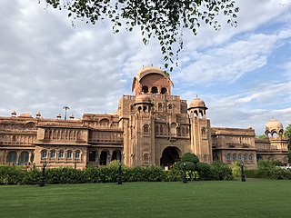
Bikaner is a city in the northwest of the state of Rajasthan, India. It is located 330 kilometres (205 mi) northwest of the state capital, Jaipur. Bikaner city is the administrative headquarters of Bikaner District and Bikaner division.

Manipal is a suburb and university town within Udupi, in coastal Karnataka, India. Manipal is located five kilometres away from the centre of Udupi City, in Udupi District, Karnataka (state) in south western India. It is administered by the Udupi City Municipality. The suburb is located in coastal Karnataka, 62 km north of Mangalore and 8 km east of the Arabian Sea. From its location on a plateau, at an altitude of about 75 metres above sea level, it commands a panoramic view of the Arabian Sea to the west and the Western Ghats to the east.

Dang is a district in the southeastern part of the state of Gujarat in western India. The administrative headquarters of the district are located in Ahwa. Dang has an area of 1,764 km2 and a population of 228,291. As of 2011, it is the least populous of Gujarat's 33 districts. As per the Planning Commission, Dang is one of the most economically distressed district out of 640 districts in India. 94% of the population belongs to one of the scheduled tribes. The five Kings of Dangs are the only hereditary royals in India whose titles are currently recognized by the government owing to an agreement between the Government of India and the Dang kings in 1842.

Navsari is an administrative district in the state of Gujarat in India, with its headquarters at the city of Navsari. The district covers an area of 2,211 square kilometres and was formed in 1997 after Valsad district was split into Valsad and Navsari districts. It is the largest producer of chikoos in India.
Waghai is a town in the Dang District of the southern part of Gujarat state in India. And also Taluka of dang district. Waghai is about 32 km west of the district headquarters of Ahwa, and about 52 km north-west of the hill station of Saputara. Vansda, Chikhli and Bilimora are located westerly. It is linked by state highway to the town of Chikhli, and by a narrow gauge to the town of Bilimora. Also with Saputara a NG passenger train named. Waghai Passenger link these towns of south Gujarat.
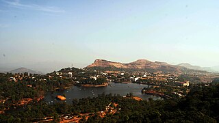
Saputara is a hill station located in Sahyadris or Western Ghats. Saputara town is part of Dang district in Gujarat, India. It is a tourist destination.
Bilimora is a city situated on the banks of the river Ambika, in Gandevi taluka & Navsari district of Gujarat state, in India. The city comes under the purview of the Surat Metropolitan Region. The city is roughly 70 kilometres (43 mi) south of the city of Surat and is the southernmost point of the Surat Metropolitan Region and the Metropolis of Surat. It is linked to Surat by SH 6 and SH 88.
Poornima Arvind Pakvasa, known as the Didi of Dangs, was an Indian independence activist and social worker from Gujarat.

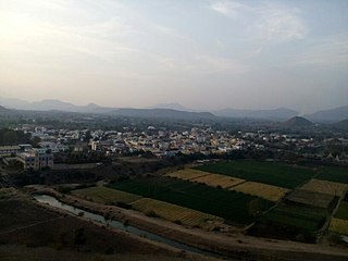
Chikhli is a midsize town in Navsari district in the state of Gujarat, India.
Alipor is a village near Chikhli, Bilimora in the state of Gujarat in western India. The village is on the Indian National Highway 8, which leads to areas such as Ahwa via Waghai and Vansda, and to the hill station of Saputara.

South Gujarat, also known as Dakshin Gujarat, is a region in the Indian state of Gujarat. The region has a wetter climate than other regions of Gujarat. The western part is almost coastal and is known as Kantha Vistar, and the eastern part is also known as Dungar Vistar, which ranges from 100 to 1000 metres, with the highest peak at Saputara in the Dang district.

Gujarat is a state in Western India. It has the India's Longest Coastline of 1214 km and It also has the one of the Largest Salt Desert in the World with the Area of 7500 Sq. km.

Gujarat is a state along the western coast of India. Its coastline of about 1,600 km (990 mi) is the longest in the country, most of which lies on the Kathiawar peninsula. Gujarat is the fifth-largest Indian state by area, with an area of 196,024 km2 (75,685 sq mi); and the ninth-most populous state, with a population of 60.4 million. It is a popular tourist destination in the country, and was visited by 19.5 million domestic tourists ; and 210 thousand international tourists in 2020.
Tembrungharta is a village in the Dang district of Gujarat, India, and is located on the road connecting the Dang district headquarters Ahwa and the Saputara hill station.

Mandvi is a town located in the Mandvi tehsil of Surat District, Gujarat state, India and lies on the banks of the Tapti River. It is around 61 kilometres (38 mi) east of Surat.
Abhona is a village in Kalwan tehsil of Nashik district in the Indian state of Maharashtra. It belongs to the North Maharashtra region.

Purna Wildlife Sanctuary is a wildlife sanctuary in the Western Ghats mountain range, in the States of Gujarat and Maharashtra, India. In the South Gujarat, it is located between Vyara, Tapi District and Ahwa, Dang District, and in Maharashtra, it is located in Nandurbar District. Apart from the Dangs' District, it is a part of the Northern Division of the Dangs' Forest.
Hatgad Fort is a fort located 71 km (44 mi)from Nashik, Nashik district, of Maharashtra. The base village is Hatgad on the Nashik-Saputara Road. The nearest town is Saputara, which is 6 km from Hatgad village. It is a historic monument located in Maharashtra, India, south of the hill station of Saputara and near the border with Gujarat. It was built by the Maratha king Shivaji and is located at an elevation of about 3,600 feet. The way to reach the fort is through a trekking route via a narrow rocky path and car also go up to the stairs of fort. A statue of Lord Shivling is placed on the top of the fort.
The Tourism Corporation of Gujarat, operating under the brand of Gujarat Tourism, is a government undertaking formed in 1978 to promote tourism in the Indian state of Gujarat and guide tourists visiting Gujarat.

Saputara Lake is a man made lake situated in Dang district in the Indian state of Gujarat. The lake is 1 kilometer from the main city hill station Saputara town, which is a tourist destination.

