Jharan

Last updated
Jharan
Village
India Gujarat location map.svg
Red pog.svg
Jharan
Location in Gujarat, India
India location map.svg
Red pog.svg
Jharan
Jharan (India)
Coordinates: 20°57′50″N73°47′10″E / 20.9638444°N 73.7860276°E / 20.9638444; 73.7860276 Coordinates: 20°57′50″N73°47′10″E / 20.9638444°N 73.7860276°E / 20.9638444; 73.7860276
CountryFlag of India.svg  India
State Gujarat
District Dang
Government
  Type Gram / Panchayat
  Body Subir Taluka / Panchayat
Elevation 408 m (1,339 ft)
Population (2011) [1]
  Total 731
Languages
  Official Konkani, Gujarati, Hindi
Time zone IST (UTC+5:30)
PIN 394716
Vehicle registration GJ 30

Jharan is a village in Dang district, Gujarat, India. It is located in the Subir taluka.

Dang District, India district in Gujarat, India

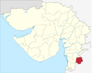
Dang is a district in the state of Gujarat in India. The administrative headquarters of the district are located in Ahwa. Dang has an area of 1,764 km² and a population of 226,769.

Gujarat State in India

Gujarat is a state on the western coast of India with a coastline of 1,600 km (990 mi) – most of which lies on the Kathiawar peninsula – and a population in excess of 60 million. It is the sixth largest Indian state by area and the ninth largest state by population. Gujarat is bordered by Rajasthan to the northeast, Daman and Diu to the south, Dadra and Nagar Haveli and Maharashtra to the southeast, Madhya Pradesh to the east, and the Arabian Sea and the Pakistani province of Sindh to the west. Its capital city is Gandhinagar, while its largest city is Ahmedabad. The Gujarati-speaking people of India are indigenous to the state. The economy of Gujarat is the fifth-largest state economy in India with 14.96 lakh crore (US$210 billion) in gross domestic product and a per capita GDP of 157,000 (US$2,200).

India Country in South Asia

India, also known as the Republic of India, is a country in South Asia. It is the seventh largest country by area and with more than 1.3 billion people, it is the second most populous country as well as the most populous democracy in the world. Bounded by the Indian Ocean on the south, the Arabian Sea on the southwest, and the Bay of Bengal on the southeast, it shares land borders with Pakistan to the west; China, Nepal, and Bhutan to the northeast; and Bangladesh and Myanmar to the east. In the Indian Ocean, India is in the vicinity of Sri Lanka and the Maldives, while its Andaman and Nicobar Islands share a maritime border with Thailand and Indonesia.

[2]

According to the 2011 census, it has a population of 731. [1]

Related Research Articles

Dang Tong District District in Kampot, Cambodia

Dang Tong District is a district located in Kampot Province, in southern Cambodia.

Bela, Nepal Village Development Committee in Rapti Zone, Nepal

Bela is a Village Development Committee in Dang Deokhuri District in the Rapti Zone of south-western Nepal.The village borders Balrampur district of India in the south. At the time of the 2011 Nepal census it had a population of 11,245 persons living in 2,055 individual households.The main residents being Tharu,Yadavs,Chhetri, Magar, Bahun, Dalit, and Muslims

Gobardiya Village Development Committee in Rapti Zone, Nepal

Gobardiha is a village of Gadawa Village Council in Dang Deukhuri District in the Province No 5 Zone of south-western Nepal. At the time of the 2011 Nepal census it had a population of 15,322 where total female population was 7991 and male population was 7331 and2,873 individual households.

Saudiyar Village Development Committee in Rapti Zone, Nepal

Saudiyar is a town and Village Development Committee in Dang Deokhuri District in the Rapti Zone of south-western Nepal. At the time of the 1991 Nepal census it had a population of 8,052 persons living in 1067 individual households.

Sonpur, Nepal Village Development Committee in Rapti Zone, Nepal

Sonpur is a town and Village Development Committee in Dang Deokhuri District in the Rapti Zone of south-western Nepal. At the time of the 1991 Nepal census it had a population of 8,650 persons living in 1129 individual households.

Tarigaun Village of Tulsipur Sub-Metropolian City in Province No. 5, Nepal

Tarigaun is a village and former Village Development Committee that is now part of Tulsipur Sub-Metropolian City in Dang Deokhuri District in Province No. 5 of south-western Nepal. It was annexed into Tulsipur in 2014. At the time of the 1991 Nepal census it had a population of 7,685 persons living in 1087 individual households.

Darreh Dang village in Lorestan, Iran

Darreh Dang is a village in Zaz-e Gharbi Rural District, Zaz va Mahru District, Aligudarz County, Lorestan Province, Iran. At the 2006 census, its population was 451, in 67 families, making it the most populous village in the rural district.

Yek Dang village in Lorestan, Iran

Yek Dang is a village in Chalanchulan Rural District, Silakhor District, Dorud County, Lorestan Province, Iran. At the 2006 census, its population was 406, in 99 families.

Qarah Dang village in Golestan, Iran

Qarah Dang is a village in Atrak Rural District, Dashli Borun District, Gonbad-e Qabus County, Golestan Province, Iran. At the 2006 census, its population was 209, in 51 families.

Khvajeh Nezam-e Chahar Dang village in Kerman, Iran

Khvajeh Nezam-e Chahar Dang is a village in Howmeh Rural District, in the Central District of Bam County, Kerman Province, Iran. At the 2006 census, its population was 203, in 49 families.

Dang-e Nim village in Kerman, Iran

Dang-e Nim is a village in Derakhtengan Rural District, in the Central District of Kerman County, Kerman Province, Iran. At the 2006 census, its population was 69, in 24 families.

Goruran-e Chahar Dang village in Kermanshah, Iran

Goruran-e Chahar Dang is a village in Miyan Darband Rural District, in the Central District of Kermanshah County, Kermanshah Province, Iran. At the 2006 census, its population was 169, in 39 families.

Goruran-e Do Dang village in Kermanshah, Iran

Goruran-e Do Dang is a village in Miyan Darband Rural District, in the Central District of Kermanshah County, Kermanshah Province, Iran. At the 2006 census, its population was 166, in 38 families.

Dang Sarak, Neka village in Mazandaran, Iran

Dang Sarak is a village in Qareh Toghan Rural District, in the Central District of Neka County, Mazandaran Province, Iran. At the 2006 census, its population was 2,008, in 577 families.

Ab Dang Sar, Savadkuh village in Mazandaran, Iran

Ab Dang Sar is a village in Sharq va Gharb-e Shirgah Rural District, Shirgah District, Savadkuh County, Mazandaran Province, Iran. At the 2006 census, its population was 266, in 59 families.

Khajan-e Chahar Dang village in Gilan, Iran

Khajan-e Chahar Dang is a village in Howmeh Rural District, in the Central District of Rasht County, Gilan Province, Iran. At the 2006 census, its population was 553, in 143 families.

Khajan-e Do Dang village in Gilan, Iran

Khajan-e Do Dang is a village in Howmeh Rural District, in the Central District of Rasht County, Gilan Province, Iran. At the 2006 census, its population was 143, in 39 families.

Mahmudabad-e Do Dang village in Fars, Iran

Mahmudabad-e Do Dang is a village in Tasuj Rural District, in the Central District of Kavar County, Fars Province, Iran. At the 2006 census, its population was 1,353, in 268 families.

Mahmudabad-e Yek Dang village in Fars, Iran

Mahmudabad-e Yek Dang is a village in Tasuj Rural District, in the Central District of Kavar County, Fars Province, Iran. At the 2006 census, its population was 507, in 126 families.

Mahmudabad-e Seh Dang village in Fars, Iran

Mahmudabad-e Seh Dang is a village in Tasuj Rural District, in the Central District of Kavar County, Fars Province, Iran. At the 2006 census, its population was 883, in 205 families.

References