
Viracopos – Campinas International Airport is an international airport serving the municipality of Campinas, in the São Paulo State. On 6 January 1987, the airport name was officially normalized to its present form. It is named after the neighborhood where it is located. It is operated by Aeroportos Brasil Viracopos.

São Paulo is one of the 26 states of the Federative Republic of Brazil and is named after Saint Paul of Tarsus. As the richest Brazilian state and a major industrial complex, often dubbed the "locomotive of Brazil", the state, which has 21.9% of the Brazilian population, is responsible for 33.9% of the Brazilian GDP. São Paulo also has the second-highest Human Development Index (HDI) and GDP per capita, the fourth-lowest infant mortality rate, the third-highest life expectancy, and the third-lowest rate of illiteracy among the federative units of Brazil, being by far, the safest state in the country. The homicide rate is 3.8 per 100 thousand as of 2018, almost 1/4 of the Brazilian rate. São Paulo alone is richer than Argentina, Uruguay, Paraguay, and Bolivia combined. The economy of São Paulo state is the most developed in Brazil. São Paulo is also the world's twenty-eighth-most populous sub-national entity and the most populous sub-national entity in the Americas.
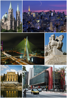
São Paulo is a municipality in the Southeast Region of Brazil. The metropolis is an alpha global city and the most populous city in Brazil, the Americas, the Western Hemisphere and the Southern Hemisphere. Additionally, São Paulo is the largest Portuguese-speaking city in the world. The municipality is also the world's 4th largest city proper by population. The city is the capital of the surrounding state of São Paulo, the most populous and wealthiest state in Brazil. It exerts strong international influences in commerce, finance, arts and entertainment. The name of the city honors the Apostle, Saint Paul of Tarsus. The city's metropolitan area, the Greater São Paulo, ranks as the most populous in Brazil and the 12th most populous on Earth. The process of conurbation between the metropolitan areas located around the Greater São Paulo created the São Paulo Macrometropolis, a megalopolis with more than 30 million inhabitants, one of the most populous urban agglomerations in the world.
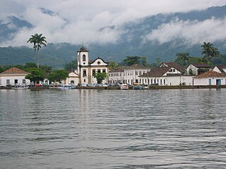
Paraty is a preserved Portuguese colonial (1500–1822) and Brazilian Imperial (1822–1889) municipality with a population of about 36,000. It is located on the Costa Verde, a lush green corridor that runs along the coastline of the state of Rio de Janeiro, in Brazil. Paraty has become a tourist destination, known for its historic town center and the coast and mountains in the region. The historic center of the city, as well as four areas of the Atlantic Forest, were inscribed on UNESCO World Heritage List in 2019 under the title "Paraty and Ilha Grande".

São Paulo/Guarulhos – Governador André Franco Montoro International Airport, often referred to by its IATA designation GRU, is the primary international airport serving São Paulo. It is popularly known locally as either Cumbica Airport, after the district where it is located and the Brazilian Air Force base that still exists at the airport complex, or Guarulhos Airport, after the municipality of Guarulhos, in the São Paulo metropolitan area, where it is located. Since November 28, 2001 the airport has been named after André Franco Montoro (1916–1999), former Governor of São Paulo state. The airport was rebranded as GRU Airport in 2012.

Guarulhos is a Brazilian municipality. It is the second most populous city in the Brazilian state of São Paulo, the 13th most populous city in Brazil, and is also the most populous city in the country that is not a state capital. In the last few years it has outgrown Campinas. It is part of the Metropolitan Region of São Paulo. The population is 1,324,781 in an area of 318.68 km2. It is the most populous non-capital city in the country and has the second-largest GDP in the state, the 8th largest in the country.

Empresa Brasileira de Infraestrutura Aeroportuária, Infraero in short, is a Brazilian government corporation founded in 1973, authorized by Law 5,862, being responsible for operating the main Brazilian commercial airports. In 2011 Infraero's airports carried 179,482,228 passengers and 1,464,484 tons of cargo and operated 2,893,631 take-offs and landings. Prresently it manages 45 airports.

São Paulo/Congonhas–Deputado Freitas Nobre Airport[kõˈɡõɲɐs] is one of the four commercial airports serving São Paulo, Brazil. The airport is named after the neighborhood where it is located, formerly called Vila Congonhas, property of the descendants of Lucas Antônio Monteiro de Barros (1767–1851), Viscount of Congonhas do Campo, first president of the Province of São Paulo after the independence of Brazil in 1822, during the Empire. In turn, the Viscount's domain was named after the plural of a shrub known in Brazil as congonha-do-campo. Since June 19, 2017 it is officially named after Deputy Freitas Nobre. The name Congonhas however remains mostly used. It is owned by the City of São Paulo, but operated by Infraero.
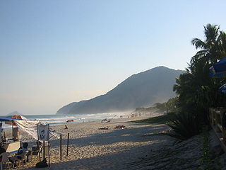
São Sebastião is a Brazilian municipality, located on the southeast coast of Brazil, in the state of São Paulo. The population in 2009 was 76,344, its density was 182.5/km² and the area is 403 km². The Tropic of Capricorn lies 25 km north. The municipality existed since 1636 and formed a part of the old hereditary captaincy of Santo Amaro.

The São Paulo See Metropolitan Cathedral --"See" and "cathedral" mean "seat" and therefore the ecclesiastical authority of a bishop or archbishop is the cathedral of the Roman Catholic Archdiocese of São Paulo, Brazil. As of 2013 the Metropolitan Archbishop of the archdiocese was Cardinal Odilo Pedro Scherer. Its construction, in Neo-Gothic style, began in 1913 and ended four decades later. It was ready for its dedication on the 400th anniversary of the foundation of the then humble villa of São Paulo by Chief or Cacique Tibiriçá and the Jesuit priests Manuel da Nóbrega and José de Anchieta. Despite having a Renaissance-styled dome, the São Paulo Metropolitan Cathedral is considered by some to be the 4th largest neo-gothic cathedral in the world.

The Microregion of Caraguatatuba, often referred as Litoral Norte, is a microregion in the easternmost coastal part of São Paulo State, Brazil. The microregion is bordered by the state of Rio de Janeiro to the east. It is a famous touristic destination, mainly because of the 160 beaches. According to IBGE, Caraguatatuba Microregion has a GDP of R$2,019,94,.048,00 and a population of 281,532 people spread over an area of 1,947.702 km², which means that the density is 144.5/km². The population increases considerably during the summer, because of the tourists.

The Amazing Race: A Corrida Milionária was a Brazilian version of the popular franchised reality television show The Amazing Race. Hosted by Rony Curvelo, it was independently produced and aired in a purchased time slot in the Brazilian television network RedeTV!. The show premiered on 13 October 2007 and ended on 5 January 2008.
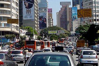
Transport in São Paulo plays a key role in the daily lives of the people of São Paulo and offers various methods of public transport that are offered in the city, including a complex bus system run by SPTrans, and various subway and railway lines. A contactless smartcard is used to pay fares for the buses, subway, and railway systems. São Paulo also has three airports.

Santa Cruz is a former civil parish in the municipality of Coimbra, Portugal. In 2013, the parish merged into the new parish Coimbra. In 2001, its population was 6866 inhabitants, in an area of 5.56 km² that parallels the north (right) margin of the Mondego River, extending to the village of Adémia in Trouxemil.
The fourth season of The Amazing Race is the fourth installment of the Latin American reality television game show The Amazing Race. Edição Brasil is the second season to be aired on the channel, Space, in association with Disney Media Networks Latin America. It featured eleven teams of two, with a pre-existing relationship, in a race across Latin America to win US$250,000.

Bixiga is a neighbourhood in the center of the city of São Paulo, Brazil. It is located within the district of Bela Vista. Bixiga is known for having been a hub for Italian immigrants.

Monument to the Bandeiras is a large-scale granite sculpture by the Italian-Brazilian sculptor Victor Brecheret (1894-1955) at the entrance of Ibirapuera Park in São Paulo, Brazil. It was commissioned by the government of São Paulo in 1921 and completed in 1954. It commemorates the 17th-century bandeiras, or settling expeditions into the interior of Brazil, and the bandeirantes that participated in them. The monument is huge and in a prominent location, making it an easily identifiable part of the landscape of São Paulo.

The Archbishop's Palace of Salvador is a Roman Catholic residence in Salvador, Bahia, Brazil. It is located on the Praça da Sé in the Pelourinho historical district of the city. The palace was built in the early eighteenth century and is one of the best examples of Portuguese colonial-period civil architecture in Brazil. The Archbishop's Palace was listed as a historic structure by the National Historic and Artistic Heritage Institute in 1938. IPHAN transferred ownership of the palace to the Roman Catholic Archdiocese of São Salvador da Bahia in 2011. The palace sits within the UNESCO World Heritage Site of the Historic Center of Salvador. Part of the structure was converted into a cultural center, the Cultural Center of the Palácio da Sé, which opened in 2020.

Veridiana Valéria da Silva Prado was a Brazilian aristocrat, landowner and intellectual. She had a significant influence in social, political and cultural life of the city of São Paulo at the end of the Empire and the beginning of the First Republic.

The São Paulo da Gamboa Battery is a military fortification located in Salvador, Bahia in Brazil. It is also known as the Fort of São Paulo da Gambôa, or simply the Fort of Gambôa. The battery was built in the early 17th century as part of a series of military fortifications in Salvador by Jean Massé, a French military engineer. The battery was built as an extension of the Fort of Saint Peter; it functioned to defend the city against Dutch and French attacks. The battery was listed as a historic structure by the National Institute of Historic and Artistic Heritage (IPHAN) in 1938. Despite its listing as a federal historic structure, it is not under the care of any public agency or institution. The battery is in an advanced state of disrepair, occupied by informal settlements, and is below a slope prone to landslides.
