
Alexandra Mountains is a group of low, separated mountains in the north portion of Edward VII Peninsula, just southwest of Sulzberger Bay in Marie Byrd Land, Antarctica. Discovered in January–February 1902 by the British National Antarctic Expedition during an exploratory cruise of the Discovery along the Ross Ice Shelf. Named for Alexandra, then Queen of the United Kingdom.
Shoemake Nunatak is a nunatak immediately west of Billey Bluff at the southwest end of the Ickes Mountains, coastal Marie Byrd Land. The nunatak was photographed from aircraft of the United States Antarctic Service (USAS), 1939–41, and was mapped by the United States Geological Survey (USGS) from surveys and U.S. Navy aerial photography, 1959-65. Named by Advisory Committee on Antarctic Names (US-ACAN) for John L. Shoemake, aerographer, U.S. Navy, weather observer at Brockton Station on the Ross Ice Shelf during two summer seasons, 1968–69 and 1969-70.
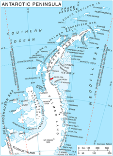
Arctowski Nunatak is a nunatak 2 miles (3 km) northwest of Hertha Nunatak in the Seal Nunataks group, off the east coast of the Antarctic Peninsula. It was charted by the Swedish Antarctic Expedition under Otto Nordenskiöld during a sledge journey in 1902, and named by him for Henryk Arctowski, Polish geologist, oceanographer, and meteorologist of the Belgian Antarctic Expedition, 1897–99.
Åkerlundh Nunatak is a nunatak which lies 2 miles (3 km) northwest of Donald Nunatak between Bruce Nunatak and Murdoch Nunatak in the Seal Nunataks group, off the east coast of Antarctic Peninsula. Charted in 1947 by the Falkland Islands Dependencies Survey, who named it for Gustaf Åkerlundh, a member of the Swedish Antarctic Expedition, 1901–04.
Archer Glacier is a glacier flowing northwest into the head of Bolson Cove, Flandres Bay, on the west coast of Graham Land. It was first charted by the Belgian Antarctic Expedition under Adrien de Gerlache, 1897–99, and named by the United Kingdom Antarctic Place-Names Committee in 1960 for Frederick Scott Archer, an English architect who in 1849 invented the wet collodion process of photography, the first practical process on glass.
Bruce Nunatak is a nunatak which lies 2 nautical miles (4 km) west of Donald Nunatak in the Seal Nunataks group, off the east coast of the Antarctic Peninsula. It was first charted in 1902 by the Swedish Antarctic Expedition under Otto Nordenskiöld, who named it for Dr. William S. Bruce, the leader of the Scottish National Antarctic Expedition, 1902–04.
Bull Nunatak is a nunatak which lies 3 nautical miles (6 km) west of Bruce Nunatak in the Seal Nunataks group, off the east coast of the Antarctic Peninsula. It was first charted in 1902 by the Swedish Antarctic Expedition under Otto Nordenskiöld, and named by him for Henrik Johan Bull, leader with Captain Leonard Kristensen of a Norwegian expedition to the Antarctic, 1894–95.
Castor Nunatak is a nunatak 3 nautical miles (6 km) southwest of Oceana Nunatak in the Seal Nunataks group, off the east coast of the Antarctic Peninsula. It was first seen and mapped as an island in December 1893 by a Norwegian Sealing expedition under C.A. Larsen, who named it after the Castor, a ship which combined sealing and exploring activities along the west coast of the Antarctic Peninsula under Captain Morten Pedersen in 1893–94. The feature was determined to be a nunatak in 1902 by the Swedish Antarctic Expedition under Otto Nordenskiöld.
Christensen Nunatak is a nunatak 1 nautical mile (2 km) north of Robertson Island in the Seal Nunataks group, off the east coast of the Antarctic Peninsula. It was discovered in 1893 by a Norwegian expedition under C.A. Larsen, who named it for Christen Christensen of Sandefjord, Norway, a pioneer of modern Antarctic whaling. It was surveyed in 1902 by the Swedish Antarctic Expedition under Otto Nordenskiöld, and in 1947 and 1953 by the Falkland Islands Dependencies Survey.
Dallmann Nunatak is a nunatak 5 nautical miles (9 km) north of Bruce Nunatak in the Seal Nunataks group, off the east coast of the Antarctic Peninsula. It was first charted in 1902 by the Swedish Antarctic Expedition under Otto Nordenskiöld, and named by him for Captain Eduard Dallmann.
The Krasin Nunataks are a small group of nunataks lying 10 nautical miles (19 km) southeast of Alderdice Peak in the Nye Mountains of Enderby Land, Antarctica. The features were plotted by the Soviet Antarctic Expedition, 1961–62, which named them after the Soviet icebreaker Krasin.
The Freyberg Mountains are a group of mountains in Victoria Land, Antarctica, bounded by Rennick Glacier, Bowers Mountains, Black Glacier, and Evans Neve. Named for New Zealand's most famous General, Lord Bernard Freyberg, by the Northern Party of New Zealand Geological Survey Antarctic Expedition (NZGSAE), 1963-64. This mountain group includes the Alamein Range. These topographical features all lie situated on the Pennell Coast, a portion of Antarctica lying between Cape Williams and Cape Adare.
Pylon Point is a rocky promontory standing 4 nautical miles (7 km) southwest of Three Slice Nunatak and marking the north end of the main mountainous mass of Joerg Peninsula, on the east coast of Graham Land. Pylon Point lies in the area first seen by Sir Hubert Wilkins on his flight of December 20, 1928, and crossed by Lincoln Ellsworth on his flight of November 21, 1935. So named by the US-SCAN because the various flights and sledge trips of the United States Antarctic Service (USAS), 1939–41, rounded it on their way south along the east coast of Antarctic Peninsula.

Gerry Glacier is a glacier on Edward VII Peninsula, Antarctica, flowing north between Reeves Peninsula and the Howard Heights to the head of Sulzberger Bay. Features in this area were photographed from the air and mapped by the Byrd Antarctic Expeditions, 1928–30 and 1933–35. This glacier was mapped by the United States Geological Survey from surveys and U.S. Navy air photos, 1959–65, and was named by the Advisory Committee on Antarctic Names for U.S. Senator Peter G. Gerry of Rhode Island, a long-time friend of the Byrd family and a contributor to the 1933–35 expedition.
Mount Martine is a massive mountain, about 800 metres (2,600 ft) high, with a prominent rocky north face and ice-covered south slopes, overlooking the north shore of Charcot Island, south of Cheesman Island, in the east Bellinghausen Sea of Antarctica.
Mayman Nunatak is a low rock outcrop, which has a domed appearance from the northeast, about 6 nautical miles (11 km) southwest of Taylor Platform in the Prince Charles Mountains of Antarctica. It was plotted from Australian National Antarctic Research Expeditions air photos taken in 1956 and 1960, and was named by the Antarctic Names Committee of Australia for Dr. K.J. Mayman, medical officer at Davis Station in 1964.
Stephenson Nunatak is a prominent, pyramid-shaped rock nunatak, rising to about 640 m, which rises 300 m above the surrounding ice at the northwest side of Kirwan Inlet in the southeast part of Alexander Island, Antarctica. Discovered and roughly surveyed in 1940-41 by Ronne and Eklund of the United States Antarctic Service. Resurveyed in 1949 by the Falkland Islands Dependencies Survey and named by the United Kingdom Antarctic Place-Names Committee for Alfred Stephenson, surveyor with the British Graham Land Expedition, who led a sledge party south into George VI Sound to about 72S in 1936. There happens to be another landform on Alexander Island which is named after Alfred Stephenson, that being Mount Stephenson, the highest point of Alexander Island rising to 2,987 m.
Rebholz Nunatak is an isolated nunatak just north of the Hudson Mountains, located 8 nautical miles (15 km) north-northwest of Teeters Nunatak. Mapped by United States Geological Survey (USGS) from ground surveys and U.S. Navy air photos, 1960-66. Named by Advisory Committee on Antarctic Names (US-ACAN) for Maj. Edward Rebholz, operations officer of the U.S. Army Aviation Detachment which supported the Ellsworth Land Survey, 1968-69.


