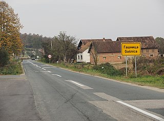
Donji Podgradci

Last updated
Donji Podgradci
Village
Bosnia and Herzegovina location map.svg
Red pog.svg
Donji Podgradci
Coordinates: 45°04′49″N17°04′50″E / 45.08028°N 17.08056°E / 45.08028; 17.08056
Country Bosnia and Herzegovina
Entity Republika Srpska
Municipality Gradiška
Time zone CET (UTC+1)
  Summer (DST) CEST (UTC+2)

Donji Podgradci (Serbian : Доњи Подградци) is a village in the municipality of Gradiška, Republika Srpska, Bosnia and Herzegovina. [1]

Serbian language South Slavic language

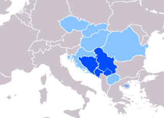
Serbian is the standardized variety of the Serbo-Croatian language mainly used by Serbs. It is the official language of Serbia, the territory of Kosovo, and one of the three official languages of Bosnia and Herzegovina. In addition, it is a recognized minority language in Montenegro where it is spoken by the relative majority of the population, as well as in Croatia, North Macedonia, Romania, Hungary, Slovakia, and the Czech Republic.

Village Small clustered human settlement smaller than a town

A village is a clustered human settlement or community, larger than a hamlet but smaller than a town, with a population ranging from a few hundred to a few thousand. Though villages are often located in rural areas, the term urban village is also applied to certain urban neighborhoods. Villages are normally permanent, with fixed dwellings; however, transient villages can occur. Further, the dwellings of a village are fairly close to one another, not scattered broadly over the landscape, as a dispersed settlement.

Municipalities of Republika Srpska

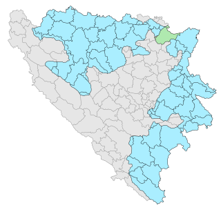
Under the "Law on Territorial Organization and Local Self-Government" adopted in 1994, Republika Srpska was divided into 80 municipalities. After the conclusion of the Dayton Peace Agreement, the law was amended in 1996 to reflect the changes to the entity's borders and now provides for the division of Republika Srpska into 64 municipalities.

Related Research Articles

Domaljevac-Šamac Town and municipality in Bosnia and Herzegovina

Domaljevac-Šamac is a town and municipality located in Posavina Canton of the Federation of Bosnia and Herzegovina, an entity of Bosnia and Herzegovina.

Hotanj is a village in Herzegovina, in Čapljina municipality, Federation of Bosnia and Herzegovina, Bosnia and Herzegovina.

Višići human settlement in Bosnia and Herzegovina

Višići is a village in Herzegovina, in Čapljina municipality, Federation of Bosnia and Herzegovina, Bosnia and Herzegovina.

Struge, Bosnia and Herzegovina Village in Federation of Bosnia and Herzegovina, Bosnia and Herzegovina

Struge is a village in Herzegovina, in Čapljina municipality, Federation of Bosnia and Herzegovina, Bosnia and Herzegovina.

Zvirovići Village in Federation of Bosnia and Herzegovina, Bosnia and Herzegovina

Zvirovići is a village in Herzegovina, in Čapljina municipality, Federation of Bosnia and Herzegovina, Bosnia and Herzegovina.

Dragelji Village in Republika Srpska, Bosnia and Herzegovina

Dragelji is a village in the municipality of Gradiška, Republika Srpska, Bosnia and Herzegovina.

Gašnica Village in Republika Srpska, Bosnia and Herzegovina

Gašnica is a village in the municipality of Gradiška, Republika Srpska, Bosnia and Herzegovina. It is most well-known as being the birthplace of People's Hero Lepa Radić.

Miloševo Brdo Village in Republika Srpska, Bosnia and Herzegovina

Miloševo Brdo is a village in the municipality of Gradiška, Republika Srpska, Bosnia and Herzegovina.

Seferovci Village in Gradiška, Bosnia and Herzegovina

Seferovci is a village in the municipality of Gradiška, Bosnia and Herzegovina.

Goleši Village in Republika Srpska, Bosnia and Herzegovina

Goleši is a village in the municipality of Banja Luka, Republika Srpska, Bosnia and Herzegovina.

Grmuša Village in Bihać, Bosnia and Herzegovina

Grmuša is a village in the municipality of Bihać, Bosnia and Herzegovina.

Aginci Village in Republika Srpska, Bosnia and Herzegovina

Aginci is a village in the municipality of Kozarska Dubica, Republika Srpska, Bosnia and Herzegovina.

Novo Selo (Brod) Village in Republika Srpska, Bosnia and Herzegovina

Novo Selo is a village in the municipality of Brod, Republika Srpska, Bosnia and Herzegovina.

Brda, Bugojno Village in Federation of Bosnia and Herzegovina, Bosnia and Herzegovina

Brda is a village in the municipality of Bugojno, Bosnia and Herzegovina.

Kotezi, Trebinje Village in Republika Srpska, Bosnia and Herzegovina

Kotezi is a village in the municipality of Trebinje, Republika Srpska, Bosnia and Herzegovina.

Novo Selo (Kupres) Village in Republika Srpska, Bosnia and Herzegovina

Novo Selo is a village in the municipality of Kupres, Republika Srpska, Bosnia and Herzegovina.

Drinsko Village in Republika Srpska, Bosnia and Herzegovina

Drinsko is a village in the municipality of Višegrad, Bosnia and Herzegovina.

Pijavice (Višegrad) Village in Republika Srpska, Bosnia and Herzegovina

Pijavice is a village in the municipality of Višegrad, Bosnia and Herzegovina.

Bećari Village in Republika Srpska, Bosnia and Herzegovina

Bećari is a village in the municipality of Sokolac, Bosnia and Herzegovina.

Nepravdići Village in Republika Srpska, Bosnia and Herzegovina

Nepravdići is a village in the municipality of Sokolac, Bosnia and Herzegovina.

References

  1. Official results from the book: Ethnic composition of Bosnia-Herzegovina population, by municipalities and settlements, 1991. census, Zavod za statistiku Bosne i Hercegovine - Bilten no.234, Sarajevo 1991.

Coordinates: 45°04′49″N17°04′50″E / 45.08028°N 17.08056°E / 45.08028; 17.08056

Geographic coordinate system Coordinate system

A geographic coordinate system is a coordinate system that enables every location on Earth to be specified by a set of numbers, letters or symbols. The coordinates are often chosen such that one of the numbers represents a vertical position and two or three of the numbers represent a horizontal position; alternatively, a geographic position may be expressed in a combined three-dimensional Cartesian vector. A common choice of coordinates is latitude, longitude and elevation. To specify a location on a plane requires a map projection.