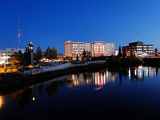
Fairbanks is a home rule city and the borough seat of the Fairbanks North Star Borough in the U.S. state of Alaska.

North Pole is a small city in the Fairbanks North Star Borough, Alaska, United States. It is part of the Fairbanks metropolitan statistical area. As of the 2010 United States Census, the city had a population of 2,117, up from 1,570 in 2000. Despite its name, the city is about 1,700 miles (2,700 km) south of Earth's geographic North Pole and 125 miles (200 km) south of the Arctic Circle.

Big Delta is a census-designated place (CDP) in Southeast Fairbanks Census Area, Alaska, United States. The population was 591 at the 2010 census, down from 749 in 2000. Big Delta is at the confluence of the Delta River and the Tanana River and gets its name from the huge river delta formed by the confluence.

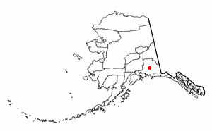
Delta Junction is a city in the Southeast Fairbanks Census Area, Alaska, United States. As of the 2010 census, the population was 958, up from 840 in 2000. The 2018 estimate was down to 931. The city is located a short distance south of the confluence of the Delta River with the Tanana River, which is at Big Delta. It is about 160 km (99 mi) south of Fairbanks. Native inhabitants are Tanana Athabaskans.

Tok is a census-designated place (CDP) in Southeast Fairbanks Census Area, Alaska, United States. The population was 1,258 at the 2010 census, down from 1,393 in 2000.

Cordova is a small town located near the mouth of the Copper River in the Valdez-Cordova Census Area, Alaska, United States, at the head of Orca Inlet on the east side of Prince William Sound. The population was 2,239 at the 2010 census, down from 2,454 in 2000. Cordova was named Puerto Cordova by Spanish explorer Salvador Fidalgo in 1790. No roads connect Cordova to other Alaskan towns, so a plane or ferry is required to travel there. In the Exxon Valdez oil spill of March 1989, an oil tanker ran aground northwest of Cordova, heavily damaging ecology and fishing. It was cleaned up shortly after, but there are lingering effects, such as a lowered population of some birds.
Glennallen is a census-designated place (CDP) in the Copper River Census Area in the Unorganized Borough of the U.S. state of Alaska. As of the 2010 census, the population of the CDP was 483, down from 554 in 2000.
The Alaska Highway was constructed during World War II to connect the contiguous United States to Alaska across Canada. It begins at the junction with several Canadian highways in Dawson Creek, British Columbia, and runs to Delta Junction, Alaska, via Whitehorse, Yukon. When it was completed in 1942, it was about 2,700 kilometres (1,700 mi) long, but in 2012, it was only 2,232 km (1,387 mi). This is due to the continuing reconstruction of the highway, which has rerouted and straightened many sections. The highway opened to the public in 1948. Once legendary for being a rough, challenging drive, the highway is now paved over its entire length. Its component highways are British Columbia Highway 97, Yukon Highway 1 and Alaska Route 2.
The Richardson Highway is a highway in the U.S. state of Alaska, running 368 miles (562 km) and connecting Valdez to Fairbanks. It is marked as Alaska Route 4 from Valdez to Delta Junction and as Alaska Route 2 from there to Fairbanks. It also connects segments of Alaska Route 1 between the Glenn Highway and the Tok Cut-Off. The Richardson Highway was the first major road built in Alaska.

The Delta River is an 80-mile (130 km) tributary of the Tanana River in the U.S. state of Alaska. Its name in the Ahtna language is Saas Na’ . Fed by the Tangle Lakes of the Alaska Range, the river flows north to meet the larger river near Big Delta.
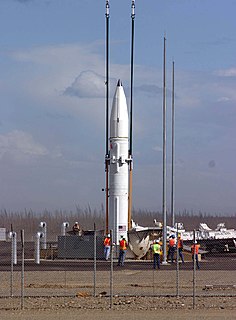
Fort Greely is a United States Army launch site for anti-ballistic missiles located about 100 miles (160 km) southeast of Fairbanks, Alaska. It is also the home of the Cold Regions Test Center (CRTC), as Fort Greely is one of the coldest areas in Alaska, and can accommodate cold, extreme-cold, and temperate-weather tests depending on the season. It is named in honor of Major General Adolphus Greely.

Eagle River is a community within the Municipality of Anchorage situated on the Eagle River, for which it is named, between Joint Base Elmendorf-Richardson and Chugach State Park in the Chugach Mountains. Its ZIP code is 99577. Settled by homesteaders, Eagle River has been annexed to the Municipality of Anchorage since the 1970s—a relationship that is, at times, complicated. On the one hand, Eagle River functions as an Anchorage suburb, with a number of Eagle River residents working in, shopping or participating in community life in the Anchorage bowl. Much of the community is also made up of residents from nearby Joint Base Elmendorf-Richardson. On the other hand, the community is itself a significant business hub between Wasilla and Anchorage, offering shopping, restaurants, recreation and employment. Secession efforts have from time to time gained traction by residents who would like Eagle River legally regarded as a separate community. Eagle River also has a close relationship with its neighboring community to the north, Chugiak, with which it shares some history. If Eagle River were not part of the Municipality of Anchorage, it would be classified as one of the five largest cities in Alaska.
Alaska Route 1 (AK-1) is a state highway in the southern part of the U.S. state of Alaska. It runs from Homer northeast and east to Tok by way of Anchorage. It is one of two routes in Alaska to contain significant portions of freeway: the Seward Highway in south Anchorage and the Glenn Highway between Anchorage and Palmer.

Alaska Route 2 is a state highway in the central and east-central portions of the U.S. state of Alaska. It runs from Manley Hot Springs to the International Border, passing through Fairbanks and Delta Junction. Alaska Route 2 includes the entire length of the Alaska Highway in the state, the remainder of the highway being in the Yukon Territory and British Columbia, Canada.

Donnelly is an unincorporated community in Southeast Fairbanks Census Area, Alaska, United States. Its elevation is 1,785 feet (544 m). Located along the Richardson Highway 26 miles (42 km) south of Delta Junction, it was founded around 1904 as a telegraph station between Chitina and Fairbanks. Donnelly's buildings during its early years were log constructed.

Wasilla is a city in Matanuska-Susitna Borough, United States and the sixth-largest city in Alaska. It is located on the northern point of Cook Inlet in the Matanuska-Susitna Valley of the southcentral part of the state. The city's population was 7,831 at the 2010 census, up from 5,469 in 2000. Estimates in 2019 put the population at 10,838. Wasilla is the largest city in the borough and a part of the Anchorage metropolitan area, which had an estimated population of 399,148 in 2018.
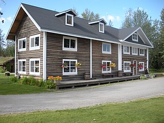
Rika's Landing Roadhouse, also known as Rika's Landing Site or the McCarty Roadhouse, is a roadhouse located at a historically important crossing of the Tanana River, in the Southeast Fairbanks Area, Alaska, United States. It is off mile 274.5 of the Richardson Highway in Big Delta.
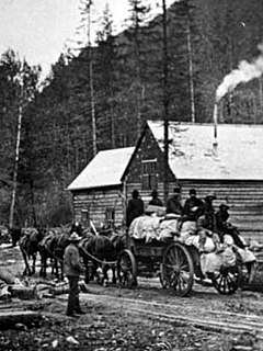
The Board of Road Commissioners for Alaska, more commonly known as the Alaska Road Commission or ARC, was created in 1905 as a board of the U.S. War Department. It was responsible for the construction and improvement of many important Alaska highways, such as the Richardson Highway, Steese Highway, Elliot Highway and Edgerton Highway, among others.
United States Army Alaska is a military command of the United States Army located in the U.S. state of Alaska. A subordinate command of I Corps, USARAK is the ground element of the Alaskan Command. USARAK is headquartered at Joint Base Elmendorf-Richardson and is commanded by a major general.

Joint Base Elmendorf–Richardson is a United States military facility in Anchorage, the largest city in Alaska. It is an amalgamation of the United States Air Force's Elmendorf Air Force Base and the United States Army's Fort Richardson, which were merged in 2010.

