Stannard Township is a civil township of Ontonagon County, in the U.S. state of Michigan. The population was 833 at the 2000 census.

Ennistymon or Ennistimon is a country market town in County Clare, near the west coast of Ireland. A popular tourist spot, it has a typical Irish main street, with many traditional pubs. The River Inagh, with its small rapids known as the Cascades, runs through the town, behind the main street. A bridge across the river leads to nearby Lahinch, on the N67 national secondary road. The town is connected to Ennis by the N85, continuing the settlement's main street.

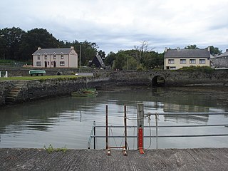
Scarriff or Scariff is a large village in east County Clare, Ireland, situated in the midwest of Ireland. The town is on the West end of Lough Derg and is best known for its harbour. The Scarriff Market House is easily recognisable, and it is therefore often used to represent the town.

Doora is a civil parish and village in County Clare, Ireland, just to the east of the town of Ennis. It is part of the Catholic parish of Doora Barefield. Parts of Doora are contained in the town of Ennis.

Cree or Creegh is a small village in West County Clare in Ireland. It is situated at a crossroads near the towns of Doonbeg and Cooraclare. The nearest large towns are Kilrush and Ennis which are 7 miles and 26 miles away respectively. The Central Statistics Office 2006 census puts the population of Cree and its townlands at 457. In recent years there have been the development of new houses near the Creegh River. In Dromheilly Cree there is a holy shrine located which every year in August has a week of masses that people from West Clare attend. Cree also has an involvement in The Rose Of Clare Festival every year as the festival parade takes place in the village.

Tubber is a village in the north of County Clare, Ireland.
Cranny is a small village in County Clare, Ireland.

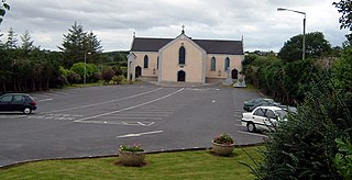
Doonbeg is a village in west County Clare, Ireland on the Atlantic coast. It is surrounded by dramatic scenery and has developed as a tourist resort. The area was officially classified as part of the West Clare Gaeltacht, an Irish-speaking community, until 1956.
Clonina or Clooneenagh is a small village in West County Clare in Ireland. It is situated on the Cree Road between Cree East and Cree North near the towns of Doonbeg and Cooraclare. The nearest large towns are Kilrush and Ennis which are 7 miles (11 km) and 26 miles (42 km) away respectively.

Quilty, historically Killty, is a small fishing village between Milltown Malbay and Doonbeg in County Clare, Ireland. Lobster, salmon, bass, herring and mackerel are landed at Quilty, formerly known for its curing industry. The area was officially classified as part of the West Clare Gaeltacht, an Irish-speaking community, until 1956.

Trump International Golf Links & Hotel Ireland, formerly Doonbeg Golf Club, is a traditional links-type course situated to the north of Doonbeg in County Clare, Ireland. Designed by Greg Norman and opened in 2002, the geography was hardly changed as the course was fitted into the area provided. The complex hosts a 5-star hotel, spa, cottages and reception rooms.

The Rineen ambush was an ambush carried out by the Irish Republican Army (IRA) on 22 September 1920, during the Irish War of Independence. It took place at Drummin Hill in the townland of Drummin, near the hamlet of Rineen, County Clare.
Doonbeg GAA is a Gaelic Athletic Association club from the village of Doonbeg in County Clare, Ireland. The club only plays gaelic football, and have won the Clare Senior Football Championship on eighteen occasions. They are the 2010 champions, having defeated Liscannor in the final by 0-11 to 0-7.
Knock is a village in County Clare, Ireland. The village is located at the northern banks of the Clonderalaw Bay, a bay connected with the Shannon, and the R486 is passing through the village.

Dough Castle is a ruined tower house at Lahinch in County Clare, western Ireland. It was established by the O'Conors in the early 14th century, but nothing remains of the original structures.

Moy House is a Georgian country house hotel in County Clare, Ireland, about 3 kilometres (1.9 mi) south of Lahinch off the N67 road near the village of Moy.

Doonbeg (Killard) is a civil parish on the Atlantic coast of County Clare in Ireland. It is also an ecclesiastical parish in the Roman Catholic Diocese of Killaloe. The largest population centre in the parish is the village of Doonbeg.

Kilkee, formerly Kilfearagh, is a Catholic parish in County Clare, Ireland. Kilfearagh is also a civil parish that covers the same area. Both lie on the Loop Head peninsula between the Atlantic ocean and the Shannon Estuary. The main settlement is the resort town of Kilkee. The parish contains many ruins, some dating to the early days of Christianity in Ireland.