
Marys River is a 40-mile (64 km) tributary of the Willamette River in the U.S. state of Oregon. From its source at the confluence of its east and west forks near Summit, it flows generally southeast from the Central Oregon Coast Range to Corvallis.

The North Yamhill River is a 31-mile (50 km) tributary of the Yamhill River in the U.S. state of Oregon. It drains an area of the Northern Oregon Coast Range, as well as part of the Willamette Valley west of the Willamette River.

The Alsea River flows 48.5 miles (78.1 km) from Alsea, an unincorporated community in the coastal mountains of the U.S. state of Oregon, to the Pacific Ocean near the city of Waldport. It begins at the confluence of the North Fork Alsea River and the South Fork Alsea River and ends in Alsea Bay, a wide estuary at Waldport. The river flows generally west-northwest in a winding course through the mountains of southern Benton and Lincoln counties, passing near the unincorporated community of Tidewater and through the Siuslaw National Forest. Its drainage basin extends into Lane County, along the headwaters of the South Fork Alsea River.
The Trask River is in northwestern Oregon in the United States. It drains a mountainous timber-producing area of the Northern Oregon Coast Range west of Portland into Tillamook Bay and the Pacific Ocean. It is one of five rivers—the Tillamook, the Trask, the Wilson, the Kilchis, and the Miami—that flow into the bay.
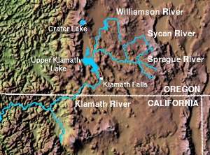
The Sprague River is a tributary of the Williamson River, approximately 75 miles (121 km) long, in southwestern Oregon in the United States. It drains an arid volcanic plateau region east of the Cascade Range in the watershed of the Klamath River.
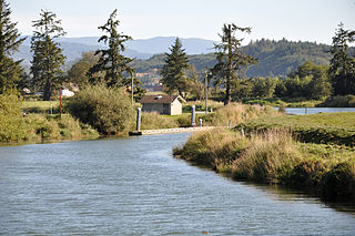
The Wallooskee River is a tributary of the Youngs River, about 10 miles (16 km) long, in northwest Oregon in the United States. It drains a small area of the foothills of the Coast Range near the mouth of the Columbia River. The Youngs River is a tributary of the Columbia River.

The Chindwin River, also known as the Ningthi River, is a river flowing entirely in Myanmar, and the largest tributary of the country's main river, the Irrawaddy. Its official name is also spelled Chindwinn.

The A689 is a road in northern England that runs east from the A595, 3.1 miles (5.0 km) to the west of Carlisle in Cumbria, to Hartlepool in County Durham.
The River Findhorn is one of the longest rivers in Scotland. Located in the north east, it flows into the Moray Firth on the north coast. It has one of the largest non-firth estuaries in Scotland.

The A1068 is a road in northern England that runs from Seaton Burn in North Tyneside to Alnwick in Northumberland. The section between Ellington and Alnmouth is signposted as part of the Northumberland Coastal Route.
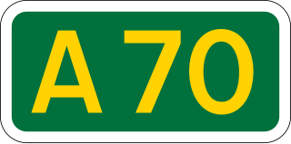
The A70 road is a major road in Scotland, United Kingdom. It runs a total of 74.3 miles (119.6 km) from Edinburgh to Ayr. It begins as Dalry Road at the Haymarket, Edinburgh junction with the A8, passing near but not through Lanark and ending as Miller Road in Ayr. Between Edinburgh city centre and Lanark it passes through the Edinburgh suburbs of Slateford, Juniper Green, Currie and Balerno; then Carnwath, Carstairs, and Ravenstruther, while between Lanark and Ayr it passes through Hyndford Bridge, Rigside, Douglas, Muirkirk, Smallburn, Cumnock, Ochiltree, and Coylton.

The A588 is a road in western Lancashire, England, which runs for around 20 miles (32 km), from Poulton-le-Fylde northeastwards to Lancaster. It is the main route serving the Over Wyre areas of the Fylde.

The Levern Water is a small river in East Renfrewshire and Glasgow, Scotland. It rises in the Long Loch and flows generally north and east, past the towns of Neilston and Barrhead, for a total distance of 9 miles (14 km). It empties into the White Cart River.

The River Garry is a major tributary of the River Tummel, itself a tributary of the River Tay, in the traditional county of Perthshire in the Scottish Highlands. It emerges from the northeastern end of Loch Garry (56.8193°N 4.2311°W), just to the southeast of the Pass of Drumochter, and flows southeastwards and eastwards down Glen Garry to the narrow Pass of Killiecrankie beyond which it joins the Tummel (56.7182°N 3.7790°W).

The River Fiddich is a right bank tributary of the River Spey in northeast Scotland. It rises on the eastern slopes of Corriehabbie Hill in Glenfiddich Forest and flows northeastwards beneath the A941 road, past Auchindoun Castle to a sharp bend adjacent to the A920 road where it turns westwards to flow to Dufftown. The Fiddich is joined on the eastern edge of the town by the Dullan Water which drains Glen Rinnes. Their combined waters then flow generally northwestwards, passing beneath the B9014 road near Balvenie Castle and then the A95 at Craigellachie immediately before meeting the Spey.

The River Dulnain is a major left bank tributary of the River Spey in northeast Scotland. It rises in the eastern part of the Monadhliath Mountains and flows in a generally northeastward direction through uninhabited country to Sluggan, where it is crossed by Sluggan Bridge, constructed by General Wade to carry a military road. Turning more easterly, the Dulnain passes beneath the modern A9 road which bypasses Carrbridge, the mainline railway and, in Carrbridge itself, the Carrbridge Packhorse Bridge that gives the village its name and the bridge carrying the B9153 road. The final section flowing east-northeast to the village of Dulnain Bridge is accompanied by the A938 road. The river empties into the Spey after passing beneath the A95 road and the disused bridge of the former Strathspey railway.
The River Nethy is a right bank tributary of the River Spey in northeast Scotland. It rises as the Garbh Allt between Cairn Gorm and A' Chòinneach on the northern slopes of the Cairngorms and flows northwards through Strath Nethy and into Abernethy Forest. Passing through Nethy Bridge where the B970 road crosses the river and gives its name to the village, the Nethy turns northwestward before entering the Spey at Broomhill. Numerous burns feed the Nethy, the most significant of which is the Dorback Burn which enters from its right bank a mile above Nethy Bridge.

The River Nairn is a 35 mile long river in the Scottish Highlands.

The River Bogie, also known as the Water of Bogie, is a river in north-west Aberdeenshire in the north east of Scotland. It is noted for its brown trout fishing.

The Ardoch Burn is a stream in Stirling council area, Scotland, which flows from the Braes Of Doune into the River Teith at Inverardoch, just behind Doune Castle.

