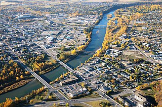
Red Deer is a city in Alberta, Canada, located midway on the Calgary–Edmonton Corridor. Red Deer serves central Alberta, and its key industries include health care, retail trade, construction, oil and gas, hospitality, manufacturing and education. It is surrounded by Red Deer County and borders on Lacombe County. The city is in aspen parkland, a region of rolling hills, alongside the Red Deer River.

Leamington is a municipality in Essex County, Ontario, Canada. With a population of 29,680 in the Canada 2021 Census, it forms the second largest urban centre in Windsor-Essex County after Windsor, Ontario. It includes Point Pelee National Park, the southernmost point of mainland Canada.

Burlington is a city and lower-tier municipality in Halton Region at the west end of Lake Ontario in Ontario, Canada. Located approximately halfway between Toronto and Niagara Falls, it is part of the Greater Toronto Area and the Hamilton census metropolitan area.
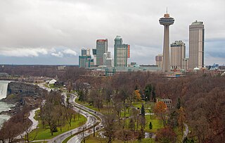
Niagara Falls is a city in Ontario, Canada, adjacent to, and named after, Niagara Falls. As of the 2021 census, the city had a population of 94,415. The city is located on the Niagara Peninsula along the western bank of the Niagara River, which forms part of the Canada–United States border, with the other side being the twin city of Niagara Falls, New York. Niagara Falls is within the Regional Municipality of Niagara and a part of the St. Catharines - Niagara Census Metropolitan Area (CMA).

LaSalle is a town in Essex County, Ontario, Canada. It is a bedroom community of the City of Windsor and part of the Windsor Census Metropolitan Area, and is located south of that city. LaSalle, along with Windsor, is the oldest French settlement area in Southwestern Ontario, and the oldest continually inhabited European settlement in Canada west of the Quebec border. The town was named for explorer René-Robert Cavelier, Sieur de La Salle.

Caledonia is a community located on the Grand River in Haldimand County, Ontario, Canada. It had a population of 12,179 as of the 2021 Canadian Census. Caledonia is within Ward 3 of Haldimand County. The Councillor elected for Ward 3 is Dan Lawrence. As of 2021, there were 4,310 private dwellings in Caledonia.

The Regional Municipality of Niagara, also colloquially known as the Niagara Region or Region of Niagara, is a regional municipality comprising twelve municipalities of Southern Ontario, Canada. The regional seat is in Thorold. It is the southern end of the Golden Horseshoe, the largest megalopolis in Canada.

New Tecumseth is a town in Simcoe County, in south-central Ontario, Canada. While it is not officially a part of the Greater Toronto Area, it is counted, in terms of the census, as being a part of the Toronto Census Metropolitan Area.

Tillsonburg is a town in Oxford County, Ontario, Canada with a population of 18,615 located about 50 kilometres southeast of London, on Highway 3 at the junction of Highway 19.
Middlesex Centre is a township in Middlesex County, in southwestern Ontario, Canada, north and west of London. The Corporation of the Township of Middlesex Centre formed on January 1, 1998, with the amalgamation of the former Townships of Delaware, Lobo, and London. It is part of the London census metropolitan area.

Thames Centre is a municipality in Middlesex County, Ontario, Canada, directly east of the City of London. It was formed on January 1, 2001, when the townships of West Nissouri and North Dorchester were amalgamated. It is part of the London census metropolitan area.

Cochrane is a town in the Calgary Metropolitan Region of Alberta, Canada. The town is located 18 km (11 mi) west of the Calgary city limits along Highway 1A. Cochrane is one of the fastest-growing communities in Canada, and with a population of 32,199 in 2021, it is one of the largest towns in Alberta. It is part of Calgary's census metropolitan area and a member community of the Calgary Metropolitan Region Board (CMRB). The town is surrounded by Rocky View County.

Annaheim is a village in the Canadian province of Saskatchewan within the Rural Municipality of St. Peter No. 369 and Census Division No. 15. The village is located about 125 km east of the City of Saskatoon, at the junction of provincial Highway 756 and Highway 779. Annaheim hosts the offices of the Rural Municipality of St. Peter No. 369.

Bonnyville is a town situated in East Northern Alberta, Canada between Cold Lake and St. Paul. The Municipal District (MD) of Bonnyville No. 87 surrounds the community.

Cold Lake is a city in east-central Alberta, Canada and is named after the lake nearby. Canadian Forces Base Cold Lake is situated within the city's outer limits.

Oyen is a town in east-central Alberta, Canada near the Saskatchewan boundary and north of Medicine Hat. It is on Highway 41, 4 km (2.5 mi) south of its junction with Highway 9.

Morinville is a town in the Edmonton Metropolitan Region of Alberta, Canada. It is approximately 34 kilometres (21 mi) north of Edmonton along Highway 2.

Blandford-Blenheim is a township in the Canadian province of Ontario, located in Oxford County. The township had a population of 7,359 in the Canada 2011 Census.

Mildmay is a community of people of primarily English and German descent in the municipality of South Bruce, Bruce County, Ontario, Canada. it is northwest of Minto and south of Walkerton on Highway 9. Formosa lies to the northwest, and Neustadt to the east. Mildmay was possibly named after "the place in England where the famous Mildmay Evangelical Meetings were held". Post office dates from 1868.
Stirling-Rawdon is a township in the Canadian province of Ontario, located in Hastings County. It was formed on January 1, 1998, through the amalgamation of Rawdon Township with the Village of Stirling. Stirling was named the 2012 Kraft Hockeyville winner, after gaining more than 3.9 million votes.


