The Arctic Archipelago, also known as the Canadian Arctic Archipelago, is a group of islands north of the Canadian mainland.

Monte Pissis is an extinct volcano on the border of La Rioja and Catamarca provinces, Argentina, 25 km (16 mi) from the Chilean border. The mountain is the third-highest in the Western Hemisphere, and is located about 550 km (340 mi) north of Aconcagua. Monte Pissis is named after Pedro José Amadeo Pissis, a French geologist who worked for the Chilean government. Due to its location in the Atacama Desert, the mountain has very dry conditions but there is an extensive glacier

Curing salt is used in meat processing to generate a pinkish shade and to extend shelf life. It is both a color agent and a means to facilitate food preservation as it prevents or slows spoilage by bacteria or fungus. Curing salts are generally a mixture of table salt and sodium nitrite and are used for pickling meats as part of the process to make sausage or cured meat such as ham, bacon, pastrami, corned beef, etc. According to the meat industry, the reason for using nitrite-curing salt is not about giving an appetizing red or pink color but to inhibit the growth of bacteria, specifically Clostridium botulinum in an effort to prevent botulism.

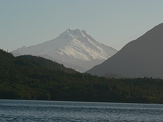
Cerro Macá is a stratovolcano located to the north of the Aisén Fjord and to the east of the Moraleda Channel, in the Aysén del General Carlos Ibáñez del Campo Region of Chile. This glacier-covered volcano lies along the regional Liquiñe-Ofqui Fault Zone.

The Itapecuru Formation is a geological formation in Itapecuru Mirim, Maranhão, Brazil.

The 1939 Chillán earthquake occurred in south-central Chile on 24 January with a surface wave magnitude of 8.3 and a maximum Mercalli intensity of X (Extreme). With a death toll of around 28,000, compared to the 2,231–6,000 of the Great Chilean earthquake of 1960, it is the single deadliest earthquake in Chile.

Cay is a stratovolcano in the South Volcanic Zone of the Andes in Aysén del General Carlos Ibáñez del Campo Region, Chile. The volcano is located 15 km northeast of the larger Maca Volcano and about 230 km of the Chile Trench at the intersection of NW-SE and NE-SW faults of the Liquiñe-Ofqui Fault Zone. The volcano is composed from basalt and dacite and there is no evidence of Holocene activity. Below 1000m, several parasitic cones lie on the southwest flank of the volcano.

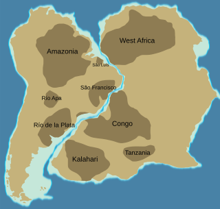
The São Francisco Craton is an ancient craton in the eastern part of South America. The craton crops out in the Brazilian states of Minas Gerais and Bahia.

The 1953 Concepción earthquake occurred on May 6 at 17:16 UTC. The epicenter was located offshore Biobío Region, Chile. It had a magnitude of Ms 7.6, or ML 7.6. Twelve people were reported dead in this earthquake.
An orocline — from the Greek words for "mountain" and "to bend" — is a bend or curvature of an orogenic belt imposed after it was formed. The term was introduced by S. Warren Carey in 1955 in a paper setting forth how complex shapes of various orogenic belts could be explained by actual bending, and that understanding this provided "the key to understanding the evolution of the continents". Carey showed that in a dozen cases where such bends were undone the results were substantially identical with continental reconstructions deduced by other means. Recognition of oroclinal bending provided strong support to the subsequent theory of plate tectonics.
Abra Granada is a volcanic complex in the Puna de Atacama in Bolivia. It is located approximately 45 kilometres (28 mi) north of Pirquitas and is composed from a lava dome, lavas and dacitic ignimbrites centering on Cerro Granada and are dated 9.8-7.8 Ma. Deposits erupted 7.9-5.0 mya by this volcano overlie the older Granada ignimbrite. Other peraluminous rocks were erupted 10 mya. The complex is the likely source of the Granada Ignimbrite. The ignimbrite reaches its maximum thickness in the complex.
Sierra de Gorbea is a large lava field in the Chilean Andes that has been dated 4.7±0.5 Ma and 5.2±0.5 Ma by potassium argon dating. The lavas are dacitic to basaltic andesite with rhyolitic inclusions and no vent is evident.
Dos Createres is a poorly researched volcano in Chile, with two edifices. It is dated 7.9±0.5 Ma mya.

The Sarandí del Yí Shear Zone is a strike slip shear zone in Uruguay. The shear zone has a NNW-SSE orientation and a dextral relative direction. It runs across the Río de la Plata Craton from the coast east of Montevideo in the south to the town of Sarandí del Yí. Sarandí del Yí Shear Zone shows a relative displacement of 40 kilometres (25 mi) and truncates the Uruguayan dyke swarm to the west.

Choiyoi Group is a Permian and Triassic-aged group of volcano-sedimentary formations in Argentina and Chile. The group bears evidence of bimodal-style volcanism related to an ancient subduction zone that existed along the western margin of the supercontinent Gondwana.
Jotabeche is a Miocene-Pliocene caldera in the Atacama Region of Chile. It is part of the volcanic Andes, more specifically of the extreme southern end of the Central Volcanic Zone (CVZ). This sector of the Andean Volcanic Belt contains about 44 volcanic centres and numerous more minor volcanic systems, as well as some caldera and ignimbrite systems. Jotabeche is located in a now inactive segment of the CVZ, the Maricunga Belt.
Leon Muerto is a 4,799 metres (15,745 ft) high volcano in Chile.
Sierra de Bequeville is a mountain range in Argentina. It is formed by two ridges, one mostly formed by Ordovician flysch and the other by rocks of uncertain age. The Eocene Geste Formation, a 500 metres (1,600 ft) thick welded tuff and correlative rocks dated to 16.7 ± 0.1 million years ago, and continental clast strata from 13.21 ± 0.6 million years ago form the rest of the range.
Taitao ophiolite is an ophiolite in Taitao Peninsula of western Patagonia, Chile. The ophiolite crops out about 10 km w to the east of the Peru-Chile trench and 50 km to the south of Chile Triple Junction —two features to which it is related.


