
Tarn is a department in the Occitanie region of Southern France. Named after the river Tarn, it had a population of 387,890 as of 2017. Its prefecture and largest city is Albi; it has a single subprefecture, Castres. In French, the inhabitants of Tarn are known as Tarnais (masculine) and Tarnaises (feminine). Its INSEE and postcode number is 81.

The Lot, originally the Olt, is a river in France. It is a right-bank tributary of the Garonne. It rises in the Cévennes mountains, flowing west through Quercy, where it flows into the Garonne near Aiguillon, a total distance of 485 kilometres (301 mi). It gives its name to the départements of Lot and Lot-et-Garonne.

The Tarn is a 380.2-kilometre (236.2 mi) long river in the administrative region of Occitania in southern France. It is a right tributary of the Garonne.
Saint-Affrique is a commune in the Aveyron department in Southern France.

Vabres-l'Abbaye is a commune in the Aveyron department in southern France.

The arrondissement of Millau is an arrondissement of France in the Aveyron department in the Occitanie region. It has 110 communes. Its population is 79,346 (2016), and its area is 3,741.7 km2 (1,444.7 sq mi).

The arrondissement of Castres is an arrondissement of France in the Tarn department in the Occitanie region. Its INSEE code is 812 and its capital city is Castres. It has 151 communes. Its population is 195,298 (2016), and its area is 3,026.2 km2 (1,168.4 sq mi). It is the southernmost arrondissement of the department.

The Agout or Agoût is a 194.4-kilometre (120.8 mi) long river in south-western France. It is a left tributary of the Tarn. Its source is in the southern Massif Central, in the Haut-Languedoc Regional Nature Park. It flows generally west through the following department and towns:

Castanet-le-Haut is a commune in the Hérault department in southern France.

Murat-sur-Vèbre is a commune in the Tarn department and Occitanie region of southern France.
Arnac-sur-Dourdou is a commune in the Aveyron department in the Occitanie region of southern France.

Balaguier-sur-Rance is a commune in the Aveyron department in the Occitanie region of southern France.
Broquiès is a commune in the Aveyron department in southern France.
Camarès is a commune in the Aveyron department in southern France.

Montlaur is a commune in the Aveyron department in southern France.

The Cérou is an 87.1 km (54.1 mi) long river in the Aveyron and Tarn departments in southern France. Its source is at Saint-Jean-Delnous, 1.8 km (1.1 mi) northwest of the village. It flows generally west-northwest. It is a left tributary of the Aveyron, into which it flows at Milhars, 1.4 km (0.87 mi) north of the village.
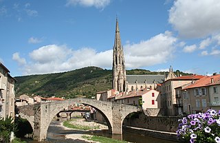
The Sorgues is a 46.4-kilometre-long (28.8 mi) river in the Aveyron department in Southern France. Its source is a karstic spring at Cornus, on the Causse du Larzac. It flows generally west-northwest. It is a right tributary of the Dourdou de Camarès, into which it flows at Vabres-l'Abbaye.

The Dourdou de Conques is an 83.7 km (52.0 mi) long river in the department of Aveyron, southern France. Its source is near the village of Lassouts. It flows generally west. It is a left tributary of the Lot, into which it flows near Grand-Vabre.
The canton of Causses-Rougiers is an administrative division of the Aveyron department, southern France. It was created at the French canton reorganisation which came into effect in March 2015. Its seat is in La Cavalerie.


