Dover station (MBTA)

Last updated
Dover
MBTA Main Line El at Dover Station in 1967.jpg
A train approaching Dover station in 1967
General information
Location Washington Street at Dover Street
Boston, Massachusetts
Coordinates 42°20′38.22″N71°3′57.59″W / 42.3439500°N 71.0659972°W / 42.3439500; -71.0659972
Line(s) Washington Street Elevated
Platforms2 side platforms
Tracks2
ConnectionsAiga bus trans.svg MBTA bus: 9,  11
Construction
Bicycle facilities2 spaces (Silver Line)
AccessibleYes (Silver Line)
History
OpenedJune 10, 1901 [1]
July 20, 2002 (Silver Line)
ClosedApril 30, 1987 [1]
RebuiltDecember 9, 1912 [2]
Passengers
20121,374 (average weekday boardings - Silver Line) [3]
Services
Preceding station MBTA.svg MBTA Following station
Union Park Street
toward Nubian
Silver Line
SL4
Herald Street
Silver Line
SL5
Herald Street
Former services
Preceding station MBTA.svg MBTA Following station
Northampton
toward Forest Hills
Orange Line Essex
toward Oak Grove
Location
Dover station (MBTA)

Dover station was an elevated rapid transit station located above Washington Street at Dover Street (now East Berkeley Street) in the South End neighborhood of Boston, Massachusetts. It served the Washington Street Elevated, part of the MBTA's Orange Line, from 1901 until 1987.

Contents

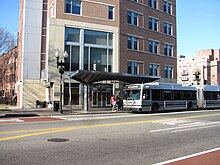
East Berkeley Street station, a street-level bus station on the Washington Street branch of the MBTA Silver Line bus rapid transit service, opened on the site in 2002. It is served by the SL4 and SL5 Silver Line routes as well as several local MBTA bus routes. Like all Silver Line stops, East Berkeley Street is accessible.

History

A southbound Silver Line bus at East Berkeley Street in 2011 East Berkeley Street Outbound, Boston MA.jpg
A southbound Silver Line bus at East Berkeley Street in 2011

The Washington Street Elevated, including Dover station, opened as part of the Main Line Elevated on June 10, 1901. [1] It was originally built with a short center island platform, similar to Northampton station to the south. Like most of the other Elevated stations, both were designed in a Beaux Arts style by Alexander Wadsworth Longfellow Jr. [2] Mere months after opening, both stations had their platforms extended for four-car trains. Eleven years later, Dover was rebuilt with two eight-car-long side platforms in a more utilitarian style, with the new station opening on December 9, 1912. A temporary wooden station was used during construction. [2] [4]

The Main Line Elevated was renamed the Orange Line in 1965. Dover station was closed on April 30, 1987, when the Washington Street Elevated was closed and the Orange Line was rerouted to the west along the Southwest Corridor. [1] Silver Line service on Washington Street began on July 20, 2002, replacing the route 49 bus. Service levels increased on October 15, 2009 with the introduction of the SL4 route. [1]

Related Research Articles

<span class="mw-page-title-main">Orange Line (MBTA)</span> Rapid transit line in Greater Boston

The Orange Line is a rapid transit line operated by the Massachusetts Bay Transportation Authority (MBTA) as part of the MBTA subway system. The line runs south on the surface from Oak Grove station in Malden, Massachusetts through Malden and Medford, paralleling the Haverhill Line, then crosses the Mystic River on a bridge into Somerville, then into Charlestown. It passes under the Charles River and runs through Downtown Boston in the Washington Street Tunnel. The line returns to the surface in the South End, then follows the Southwest Corridor southwest in a cut through Roxbury and Jamaica Plain to Forest Hills station.

<span class="mw-page-title-main">Silver Line (MBTA)</span> Bus rapid transit system in Massachusetts, US

The Silver Line is a system of bus routes in Boston and Chelsea, Massachusetts, operated by the Massachusetts Bay Transportation Authority (MBTA). It is operated as part of the MBTA bus system, but branded as bus rapid transit (BRT) as part of the MBTA subway system. Six routes are operated as part of two disconnected corridors. As of 2019, weekday ridership on the Silver Line was 39,000.

<span class="mw-page-title-main">Haymarket station (MBTA)</span> Subway station in Boston, Massachusetts, US

Haymarket station is an underground Massachusetts Bay Transportation Authority (MBTA) rapid transit station located at Haymarket Square in Boston, Massachusetts. It is a transfer station between the Green Line and Orange Line of the MBTA subway system, as well as a terminal for MBTA bus routes serving northern and northeastern suburbs. The two lines run parallel to each other through the station, with two side platforms for the Orange Line and a single island platform for the Green Line. The station is fully accessible.

<span class="mw-page-title-main">Nubian station</span> Bus and former rapid transit station in Boston, Massachusetts, US

Nubian station is a ground-level bus station located in Nubian Square in the Roxbury neighborhood of Boston, Massachusetts, United States. It is a transfer point between 16 Massachusetts Bay Transportation Authority (MBTA) bus routes, including two Silver Line bus rapid transit lines and 14 local MBTA bus routes. Like all MBTA bus stops, Nubian is fully accessible.

<span class="mw-page-title-main">Sullivan Square station</span> Rapid transit station in Boston, Massachusetts, US

Sullivan Square station is a rapid transit station on the MBTA subway Orange Line, located adjacent to Sullivan Square in the Charlestown neighborhood of Boston, Massachusetts. It is a major transfer point for MBTA bus service, with 13 routes using a two-level busway. The station has two island platforms serving the two active Orange Line tracks plus an unused third track. The Haverhill Line and Newburyport/Rockport Line pass through the station on separate tracks but do not stop.

The Massachusetts Bay Transportation Authority (MBTA) maintains a large public transit system in the Boston, Massachusetts area, and uses various methods to name and number their services for the convenience of users.

<span class="mw-page-title-main">Washington Street Elevated</span> Former elevated railroad in Boston, Massachusetts

The Washington Street Elevated was an elevated segment of Boston's Massachusetts Bay Transportation Authority subway system, comprising the southern stretch of the Orange Line. It ran from Chinatown through the South End and Roxbury, ending in Forest Hills in Jamaica Plain, Boston.

<span class="mw-page-title-main">Tufts Medical Center station</span> Subway station in Boston, Massachusetts, US

Tufts Medical Center station is an underground Massachusetts Bay Transportation Authority (MBTA) rapid transit station in Boston, Massachusetts. It serves the MBTA subway Orange Line, as well as two Silver Line bus rapid transit routes on the surface. It is named for the Tufts Medical Center and is built under a wing of the facility that crosses over Washington Street in downtown Boston between Kneeland Street in Chinatown and the Massachusetts Turnpike. The accessible station has two side platforms for the Orange Line, while Silver Line buses stop along the sidewalks on the surface next to the station entrance on Washington Street. A secondary entrance is available on Tremont Street one block to the west.

<span class="mw-page-title-main">Chinatown station (MBTA)</span> Subway station in Boston, Massachusetts, US

Chinatown station is a rapid transit station on the Massachusetts Bay Transportation Authority (MBTA) Orange Line, located at the edge of the Chinatown neighborhood in the downtown core of Boston, Massachusetts. The station has two offset side platforms, which run under Washington Street from Hayward Place to Lagrange Street. The three entrances are located at the intersection of Washington Street with Essex and Boylston streets. Like all Orange Line stations, both the subway platforms and all bus connections are fully accessible.

<span class="mw-page-title-main">MBTA subway</span> Boston region transit service

The Massachusetts Bay Transportation Authority (MBTA) operates rapid transit, light rail, and bus rapid transit services in the Boston metropolitan area, collectively referred to as the rapid transit, subway, or the T system.

<span class="mw-page-title-main">Northampton station (MBTA)</span> Former rapid transit station in Boston, Massachusetts, US

Northampton station was an elevated rapid transit station located above Washington Street at Massachusetts Avenue in the South End neighborhood of Boston, Massachusetts. It served the Washington Street Elevated, part of the MBTA's Orange Line, from 1901 until 1987.

<span class="mw-page-title-main">Melnea Cass Boulevard station</span> Bus stop in Boston, Massachusetts, US

Melnea Cass Boulevard station is a street-level bus station on the Washington Street branch of the MBTA Silver Line bus rapid transit service. It is located on Washington Street at Melnea Cass Boulevard in the Roxbury neighborhood of Boston, Massachusetts. The stop is served by the SL4 and SL5 Silver Line routes; several local MBTA bus routes stop nearby. Like all Silver Line stops, Melnea Cass Boulevard is accessible.

<span class="mw-page-title-main">Lenox Street station</span> Bus stop in Boston, Massachusetts, US

Lenox Street station is a street-level bus station on the Washington Street branch of the MBTA Silver Line bus rapid transit service. It is located on Washington Street at Lenox Street in the Roxbury neighborhood of Boston, Massachusetts. The stop is served by the SL4 and SL5 Silver Line routes as well as local MBTA bus route 8. Like all Silver Line stops, Lenox Street is accessible.

<span class="mw-page-title-main">Worcester Square station</span> Bus stop in Boston, Massachusetts, US

Worcester Square station is a street-level bus station on the Washington Street branch of the MBTA Silver Line bus rapid transit service. It is located on Washington Street at Worcester Square in the South End neighborhood of Boston, Massachusetts near the Boston Medical Center. The stop is served by the SL4 and SL5 Silver Line routes as well as local MBTA bus route 8. Like all Silver Line stops, Worcester Square is accessible.

<span class="mw-page-title-main">Newton Street station</span> Bus stop in Boston, Massachusetts, US

Newton Street station is a street-level bus station on the Washington Street branch of the MBTA Silver Line bus rapid transit service. It is located on Washington Street just south of East Newton Street and West Newton Street in the South End neighborhood of Boston, Massachusetts near the Boston University Medical Campus. The stop is served by the SL4 and SL5 Silver Line routes as well as several local MBTA bus routes. Like all Silver Line stops, Newton Street is accessible.

<span class="mw-page-title-main">Herald Street station</span> Bus stop in Boston, Massachusetts, US

Herald Street station is a street-level bus station on the Washington Street branch of the MBTA MBTA Silver Line bus rapid transit service. It is located on Washington Street just south of Herald Street in the South End neighborhood of Boston, Massachusetts. In late 2017, the inbound stop was moved half a block north due to adjacent construction. The stop is served by the SL4 and SL5 Silver Line routes as well as several local MBTA bus routes. Like all Silver Line stops, Herald Street is accessible.

<span class="mw-page-title-main">South Station (subway)</span> Subway station in Boston, Massachusetts, US

South Station is a transfer station on the MBTA rapid transit Red Line and bus rapid transit Silver Line, located at Summer Street and Atlantic Avenue in downtown Boston, Massachusetts. It is a part of the South Station complex, the second busiest transportation center in New England. Eight MBTA Commuter Rail and three Amtrak intercity rail services terminate at South Station; many of those passengers then transfer to the rapid transit lines to reach other destinations in the city. With 24,639 daily boardings in 2019, South Station is the busiest station on the MBTA rapid transit system.

<span class="mw-page-title-main">Egleston station</span> Boston MBTA former subway station

Egleston was a rapid transit station in Boston, Massachusetts. It served the Washington Street Elevated, part of the MBTA's Orange Line. It was located over Egleston Square at the intersection of Washington Street and Columbus Avenue in the Roxbury neighborhood. The station opened in November 1909, and was closed in April 1987 when the Orange Line was rerouted to the west along the Southwest Corridor.

References

  1. 1 2 3 4 5 Belcher, Jonathan. "Changes to Transit Service in the MBTA district" (PDF). Boston Street Railway Association.
  2. 1 2 3 Zaitzevsky, Cynthia R. (July 1986). "Written Historical and Descriptive Data" (PDF). National Park Service / Historic American Engineering Record. pp. 30, 33.
  3. "Ridership and Service Statistics" (PDF) (14th ed.). Massachusetts Bay Transportation Authority. 2014.
  4. Cheney, Frank; Sammarco, Anthony M. (2000). When Boston Rode The El. Arcadia Publishing. pp. 102–103. ISBN   9780738504629.

Commons-logo.svg Media related to Dover station (MBTA) at Wikimedia Commons