Related Research Articles

Scio is a town in Allegany County, New York, United States. The population was 1,833 at the 2010 census. The town is in the southern half of the county and north of the village of Wellsville.
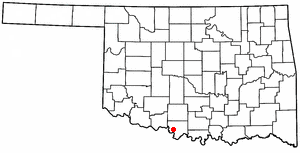
Sugden is a town in Jefferson County, Oklahoma, United States. The population was 43 at the 2010 census.

Steamboat Creek is a short tributary of the North Umpqua River in southwestern Oregon in the United States. Approximately 35 kilometres (22 mi) long, the creek is located on a remote part of the upper North Umpqua in the Calapooia Mountains west of the Cascade Range. It rises in southeastern Lane County at 43.5601214°N 122.5519948°W and flows southwest to join the North Umpqua from the north at Steamboat.
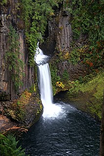
Toketee Falls is a waterfall in Douglas County, Oregon, United States, on the North Umpqua River at its confluence with the Clearwater River. It is located approximately 58 miles (93 km) east of Roseburg near Oregon Route 138.

Watson Falls is a 272-foot (83 m) waterfall on Watson Creek, a tributary of the Clearwater River, in Douglas County in the U.S. state of Oregon. It is located at an elevation of 3,353 feet (1,022 m).
The Skatin First Nations, aka the Skatin Nations, are a band government of the In-SHUCK-ch Nation, a small group of the larger St'at'imc people who are also referred to as Lower Stl'atl'imx. The Town of Skatin - the St'at'imcets version of the Chinook Jargon Skookumchuck- is located 4 km south of T'sek Hot Spring- alt. spelling T'sek Hot Spring - commonly & formerly named both St. Agnes' Well & Skookumchuck Hot Springs The community is 28 km south of the outlet of Lillooet Lake on the east side of the Lillooet River. It is approximately 75 km south of the town of Pemberton and the large reserve of the Lil'wat branch of the St'at'imc at Mount Currie. Other bands nearby are Samahquam at Baptiste Smith IR on the west side of the Lillooet River at 30 km. and Xa'xtsa First Nations; the latter is located at Port Douglas, near the mouth of the Lillooet River where it enters the head of Harrison Lake. The N'Quatqua First Nation on Anderson Lake, between Mount Currie and Lillooet, was at one time involved in joint treaty negotiations with the In-SHUCK-ch but its members have voted to withdraw, though a tribal council including the In-SHUCK-ch bands and N'Quatqua remains, the Lower Stl'atl'imx Tribal Council.

The Bohemia River is a 4.7-mile-long (7.6 km) tributary of the Elk River on the Delmarva Peninsula. It is located in Cecil County, Maryland, with its headwaters extending into New Castle County, Delaware.

Birkenhead Lake Provincial Park is a provincial park in British Columbia, Canada, located in the Lillooet Country region to the northeast of Pemberton and immediately northwest of Birkenhead Peak and Gates Lake at the community of Birken.
Toosey is a Tsilhqot'in First Nations community located west of the Fraser Canyon in the Chilcotin region of the Canadian province of British Columbia. It is a member of the Carrier-Chilcotin Tribal Council, which includes both Tsilhqot'in and Carrier (Dakelh) communities.

Millersville is an unincorporated community in northwestern Jackson Township, Sandusky County, Ohio, United States, within the Toledo Metropolitan Area. It lies at the intersection of Millersville Road and the Greensburg Pike. Muddy Creek, which flows into Sandusky Bay near the mouth of the Sandusky River, flows past the community. The community is served by the Helena (43435) post office.

Antiville is an unincorporated community in Bearcreek Township, Jay County, Indiana.
Bellvale is a populated place in San Mateo County, located at 37°18′43″N122°19′12″W. The small community is on Highway 84 between San Gregorio and La Honda. Bellvale has an elevation of 240 feet above sea level. Although Bellvale once had a post office, the community is now only sparsely settled with homes and farms. The Bellvale post office, located 2.25 miles west of La Honda, opened in 1897 and was discontinued in 1922. U.S. Geological Survey maps show oil wells in the area, tapping a relatively small pool of petroleum that was first identified in the nineteenth century.
Steamboat is an unincorporated community in Douglas County, Oregon, United States. It is located about 39 miles east of Roseburg on Oregon Route 138, near the confluence of the North Umpqua River with Steamboat Creek within the Umpqua National Forest.
Overland is a census-designated place (CDP) in Hamilton County, Nebraska, United States. The population was 153 at the 2010 census.

Lake Holm is a census-designated place (CDP) in King County, Washington, United States. The population was 3,221 at the 2010 census.

Savah is an unincorporated community in Lynn Township, Posey County, in the U.S. state of Indiana.
Phalanx is an unincorporated community in Braceville Township, Trumbull County, in the U.S. state of Ohio.
Mungy Branch is a stream in northwestern Phelps and northeastern Pulaski counties in the Ozarks of the U.S. state of Missouri. It is a tributary of Duncan Creek.
Osage Creek is a stream in Benton and Washington counties in northwest Arkansas. It is a tributary of the Illinois River.
References
Coordinates: 55°58′43″N122°18′43″W / 55.97861°N 122.31194°W