Downtown Compton

Last updated
Downtown Compton
Compton martin luther king monument.jpg
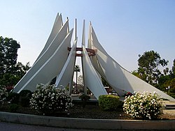
The Martin Luther King, Jr. Memorial in front of the Compton City Hall and the Superior Court building. The monument is the logo for the city and is featured on signage.
Nickname: 
Downtown C.P.T
CountryUnited States
StateCalifornia
County County of Los Angeles

Downtown Compton is the major business district of Compton, California. Downtown Compton started out as a thriving and safe environment throughout the early 1950s to the mid-1970s. When gang violence and robberies sparked in the 70s businesses began to move out and relocate leaving Downtown Compton a ghost town. It is now home to many businesses, two shopping centers, and the Martin Luther King Jr. Transit Center. [1] The Metro A Line light rail now runs through Downtown Compton making travel to the city much easier. [2]

Contents

History

1950s–1970s

Throughout the 1950s to early 1970s, Downtown Compton was a major business district and home to many companies. During weekends, streets would be packed and filled with shoppers, especially during the holidays.

1970s–1980s

During the late '70s, the face of Downtown Compton began to take a drastic turn. Robberies and ongoing gang violence due to the primarily African-American street gangs, the Crips and the Bloods, businesses began to move elsewhere to avoid further problems. [3]

1980s–1990s

During the late 80s, the face of Compton began to change after the election of mayor Omar Bradley. This included the construction of the Compton Town Center. Around this time, the Los Angeles Metro Rail system began adding the finishing touches to the Blue Line that runs straight through Downtown Compton on the median of Willowbrook Avenue. This led to the construction of the new Martin Luther King Jr. Transit Center, also located on Willowbrook along with Compton station.

Recent years

Downtown Compton is now home to the following businesses.

Related Research Articles

<span class="mw-page-title-main">Compton, California</span> City in California, United States

Compton is a city located in the Gateway Cities region of southern Los Angeles County, California, United States, situated south of downtown Los Angeles. Compton is one of the oldest cities in the county, and on May 11, 1888, was the eighth city in Los Angeles County to incorporate. As of the 2020 census, the city had a total population of 95,740. It is known as the "Hub City" due to its geographic centrality in Los Angeles County. Neighborhoods in Compton include Sunny Cove, Leland, downtown Compton, and Richland Farms.

<span class="mw-page-title-main">Willowbrook, California</span> Unincorporated community in California, United States

Willowbrook, alternatively named Willow Brook, is an unincorporated community and census-designated place (CDP) in Los Angeles County, California. The population was 24,295 at the 2020 census, down from 35,983 at the 2010 census.

<span class="mw-page-title-main">Anacostia station</span> Washington Metro station

Anacostia station is a Washington Metro station in Washington, D.C., on the Green Line. The station is located in the Anacostia neighborhood of Southeast Washington, with entrances at Shannon Place and Howard Road near Martin Luther King, Jr. Avenue SE. The station serves as a hub for Metrobus routes in Southeast, Washington, D.C., and Prince George's County, Maryland.

<span class="mw-page-title-main">Interstate 395 (Maryland)</span> Short Interstate Highway in Baltimore, Maryland

Interstate 395 (I-395) is an auxiliary Interstate Highway in the US state of Maryland. Known as Cal Ripken Way, the highway runs 1.98 miles (3.19 km) from I-95 north to Howard Street and Camden Street in Downtown Baltimore, where it provides access to the Inner Harbor and the Baltimore Convention Center. The Interstate also serves the Camden Yards Sports Complex, which contains M&T Bank Stadium and Oriole Park at Camden Yards, homes of the Baltimore Ravens and Baltimore Orioles, respectively. I-395 also serves as the southern terminus of Martin Luther King Jr. Boulevard, an urban arterial that provides a western bypass of Downtown Baltimore and connects I-95 with U.S. Route 40 (US 40), US 1, and I-83. The Interstate is maintained by the Maryland Transportation Authority (MDTA) and, like all Interstates, is a part of the National Highway System.

<span class="mw-page-title-main">Rainier Valley, Seattle</span> Neighborhood in Seattle

The Rainier Valley is a district in southeast Seattle. It is located east of Beacon Hill; west of Mount Baker, Seward Park, and Leschi; south of the Central District and north of Rainier Beach. It is part of Seattle's South End.

<span class="mw-page-title-main">Compton station</span> Los Angeles Metro Rail station

Compton station is an at-grade light rail station on the A Line of the Los Angeles Metro Rail system. The station is located alongside the Union Pacific freight railroad's Wilmington Subdivision, at its intersection with Compton Boulevard, after which the station is named, in the city of Compton, California.

<span class="mw-page-title-main">Five Points station</span> MARTA rail station

Five Points is a metro station of the Metropolitan Atlanta Rapid Transit Authority (MARTA) rail system in Atlanta, Georgia. It is the transfer point for all rail lines and serves as the main transportation hub for MARTA. It provides access to the Five Points Business District, Georgia State University, Underground Atlanta, City Hall, the Richard B. Russell Federal Building, CobbLinc, Ride Gwinnett, GRTA Xpress Transit, Station Soccer, and the tourism heart of Downtown Atlanta. It provides connecting bus service to Zoo Atlanta, Grant Park, Atlanta University Center, East Atlanta Village, Martin Luther King Jr. National Historical Park, Carter Center, Atlanta City Hall, South Dekalb Mall and Fulton County Government Center.

<span class="mw-page-title-main">MLK Jr. station (DART)</span> DART light rail station in Dallas, Texas

Martin Luther King, Jr. Station at J.B. Jackson, Jr. Transit Center is an intermodal public transit facility in Dallas, Texas operated by Dallas Area Rapid Transit. The facility is situated in South Dallas, where it serves the Green Line, four bus routes, and a curb-to-curb transit zone.

<span class="mw-page-title-main">Martin Luther King Jr. East Busway</span> Bus rapid transit line in Pittsburgh

The Martin Luther King Jr. East Busway is a two-lane bus-only highway serving the city of Pittsburgh and many of its eastern neighborhoods and suburbs. It was named after Martin Luther King Jr. in recognition of the eastern portion of the route's serving many predominantly African-American neighborhoods, such as Wilkinsburg and East Liberty. It is owned and maintained by Pittsburgh Regional Transit.

<span class="mw-page-title-main">Rainier Beach station</span> Light rail station in Seattle, Washington

Rainier Beach station is a light rail station in Seattle, Washington. It is between the Tukwila International Boulevard and Othello stations on the 1 Line. The line runs from Seattle–Tacoma International Airport to Downtown Seattle and the University of Washington as part of the Link light rail system. The station consists of an at-grade island platform south of South Henderson Street in the median of Martin Luther King Jr. Way in the Rainier Beach neighborhood, part of Seattle's Rainier Valley.

<span class="mw-page-title-main">Othello station</span> Light rail station in Seattle, Washington

Othello station is a light rail station located in Seattle, Washington. It is situated between the Rainier Beach and Columbia City stations on the 1 Line, which runs from Angle Lake through Seattle-Tacoma International Airport to Downtown Seattle and the University of Washington as part of the Link light rail system. The station consists of two at-grade side platforms between South Othello Street and South Myrtle Street in the median of Martin Luther King Jr. Way South in the NewHolly neighborhood, part of Seattle's Rainier Valley.

<span class="mw-page-title-main">Columbia City station</span> Light rail station in Seattle, Washington

Columbia City station is a light rail station located in Seattle, Washington. It is situated between the Othello and Mount Baker stations on the 1 Line, which runs from Seattle–Tacoma International Airport to Downtown Seattle and the University of Washington as part of the Link light rail system. The station consists of two at-grade side platforms between South Alaska Street and South Edmunds Street in the median of Martin Luther King Jr. Way South in the Columbia City neighborhood, part of Seattle's Rainier Valley.

<span class="mw-page-title-main">Mount Baker station</span> Light rail station in Seattle, Washington

Mount Baker station is a light rail station located in Seattle, Washington. It is situated between the Columbia City and Beacon Hill stations on the 1 Line, which runs from Seattle–Tacoma International Airport to Downtown Seattle, the University of Washington, and Northgate as part of the Link light rail system. The elevated station consists of two side platforms located west of the intersection of Rainier Avenue and Martin Luther King Jr. Way in the Mount Baker neighborhood, part of Seattle's Rainier Valley.

<span class="mw-page-title-main">Rosecrans Avenue</span> Street in Los Angeles

Rosecrans Avenue is a major west-east thoroughfare in Los Angeles and Orange Counties, California, USA. It has a total length of 27.5 miles (44.3 km). The street is named after U.S. Union General William S. Rosecrans, who purchased 13,000 acres (5,300 ha) of Rancho Sausal Redondo southwest of Los Angeles in 1869. Rosecrans Avenue was originally named Drexel Avenue, and ran through the Rosecrans Rancho which is part of modern-day Gardena.

MetroRapid is an express bus system in Tampa, Florida. Operated by Hillsborough Area Regional Transit, it incorporates some bus rapid transit features. Currently, there is only one line in operation, the North-South line, with an East-West line in the planning phase. Subsequent lines could open depending on the success of the two initial lines.

<span class="mw-page-title-main">Lindbergh, Atlanta</span> Human settlement in Atlanta, Georgia, United States of America

Lindbergh, officially Lindbergh/Morosgo, is a neighborhood in the Buckhead district of Atlanta, Georgia. Most of the neighborhood consists of multi-use development combining retail, office and residential space.

<span class="mw-page-title-main">The Gulch (Atlanta)</span>

The Gulch is an area of Downtown Atlanta, Georgia, which is unbuilt but envisioned as the site of major development.

Martin Luther King Jr. Community Hospital, also known as MLK-LA, is a 131-bed public community hospital in the unincorporated Willowbrook neighborhood of southern Los Angeles County, California, just outside of the Los Angeles city limits. It was planned and designed to especially serve the surrounding South Los Angeles communities' needs, including those of underinsured or uninsured patients.

<span class="mw-page-title-main">RapidRide G Line</span> Future bus rapid transit route in Seattle, Washington

The RapidRide G Line is a future RapidRide bus service in Seattle, Washington, operated by King County Metro on Madison Street between Downtown Seattle and Madison Valley. The line is projected to open for service on September 14, 2024, and cost $133.4 million.

<span class="mw-page-title-main">Martin Luther King Jr. Highway Line</span>

The Martin Luther King Jr. Highway Line, designated Route A12 is a daily bus route operated by the Washington Metropolitan Area Transit Authority between Addison Road station of the Blue and Silver Lines of the Washington Metro and New Carrollton station of the Orange Line of the Washington Metro. The line operates every 20 minutes between 7AM and 9PM, 30 minutes after 9PM weekdays and 60 minutes after 9PM weekends. Route A12 trips roughly take 30 minutes. On Sundays, Route A12 is extended to Capitol Heights station replacing a portion of route F14.

References

  1. Kudler, Adrian Glick (January 30, 2012). "Compton's New Transit Center Opens By Sold Out Townhouses". Curbed . Retrieved June 19, 2020.
  2. Nelson, Laura J. (October 17, 2019). "Light rail to Long Beach will reopen soon — but it won't be called the Blue Line". Los Angeles Times . Retrieved June 19, 2020.
  3. Jackson, Mitchell (2020). Survival Math: Notes on an All-American Family. Scribner p. 242. ISBN   978-1-5011-3173-8.

33°53′46″N118°13′40″W / 33.8962°N 118.2277°W / 33.8962; -118.2277