Downtown Peotone Historic District

Last updated
Downtown Peotone Historic District
Downtown Peotone Historic District.JPG
USA Illinois location map.svg
Red pog.svg
Usa edcp location map.svg
Red pog.svg
LocationRoughly North First Street and both sides of North Second Street, roughly bounded by the alley south of Main and north by North Street
Peotone, Will County, Illinois, U.S.
Coordinates 41°20′3″N87°47′29″W / 41.33417°N 87.79139°W / 41.33417; -87.79139 Coordinates: 41°20′3″N87°47′29″W / 41.33417°N 87.79139°W / 41.33417; -87.79139
Architectural styleLate 19th and Early 20th Century Movements, Queen Anne
NRHP reference # 05001253
Added to NRHPNovember 16, 2005

The Downtown Peotone Historic District is a set of forty-two buildings in Peotone, Illinois. Of these, thirty-seven contribute to the historical integrity of the area.

Peotone, Illinois Village in Illinois, United States

Peotone is a village in Will County, Illinois, United States. The population was 4,142 at the 2010 census, an increase from 3,385 in 2000. The city is about 43 miles (69 km) south of Chicago. The city is home to the Peotone High School Blue Devils.

Illinois State of the United States of America

Illinois is a state in the Midwestern and Great Lakes region of the United States. It has the fifth largest gross domestic product (GDP), the sixth largest population, and the 25th largest land area of all U.S. states. Illinois is often noted as a microcosm of the entire United States. With Chicago in northeastern Illinois, small industrial cities and immense agricultural productivity in the north and center of the state, and natural resources such as coal, timber, and petroleum in the south, Illinois has a diverse economic base, and is a major transportation hub. Chicagoland, Chicago's metropolitan area, encompasses over 65% of the state's population. The Port of Chicago connects the state to international ports via two main routes: from the Great Lakes, via the Saint Lawrence Seaway, to the Atlantic Ocean and from the Great Lakes to the Mississippi River, via the Illinois Waterway to the Illinois River. The Mississippi River, the Ohio River, and the Wabash River form parts of the boundaries of Illinois. For decades, Chicago's O'Hare International Airport has been ranked as one of the world's busiest airports. Illinois has long had a reputation as a bellwether both in social and cultural terms and, through the 1980s, in politics.

History

The Illinois Central Railroad was constructed in 1856 and provided rail service for eastern Will County. Two years later, the first commercial structure opened in the city, and residents flocked to the area. By 1865, a windmill, post office, an opera house, a trolley system, and several grain elevators had opened in the city. Peotone also housed the Will County Fair during this period. [1]

Illinois Central Railroad transport company

The Illinois Central Railroad, sometimes called the Main Line of Mid-America, was a railroad in the central United States, with its primary routes connecting Chicago, Illinois, with New Orleans, Louisiana, and Mobile, Alabama. A line also connected Chicago with Sioux City, Iowa (1870). There was a significant branch to Omaha, Nebraska (1899), west of Fort Dodge, Iowa, and another branch reaching Sioux Falls, South Dakota (1877), starting from Cherokee, Iowa. The Sioux Falls branch has been abandoned in its entirety.

Opera house theatre building used for opera performances

An opera house is a theatre building used for opera performances that consists of a stage, an orchestra pit, audience seating, and backstage facilities for costumes and set building.

The land east of Peotone was fertile, resulting in a large population of both farmers and merchants. Most business was conducted on Railroad Street, with storefronts facing the railroad tracks. Eventually business moved to Second Street, causing many of the Railroad Street businesses to simply install new storefronts on what was the rear of their building. An electric generation plant was opened in Peotone in 1894, and street lighting was added later that year. A water tower was erected in 1895, and sidewalks were laid in 1902. A portion of the district on Main Street was destroyed in a 1913 fire and rebuilt a year later. The village trolleys carried passengers from 63rd & Halsted in Chicago south to Kankakee. A major employer in the 1920s was the Continental Bridge Company, which produced many bridges in the United States and Canada, and also supplied steel for the United States Shipping Board. Development ceased in the 1930s following the Great Depression and never recovered. [1]

Water tower elevated structure supporting a water tank

A water tower is an elevated structure supporting a water tank constructed at a height sufficient to pressurize a water supply system for the distribution of potable water, and to provide emergency storage for fire protection. In some places, the term standpipe is used interchangeably to refer to a water tower. Water towers often operate in conjunction with underground or surface service reservoirs, which store treated water close to where it will be used. Other types of water towers may only store raw (non-potable) water for fire protection or industrial purposes, and may not necessarily be connected to a public water supply.

Chicago City in Illinois, United States

Chicago, officially the City of Chicago, is the most populous city in Illinois, as well as the third most populous city in the United States. With an estimated population of 2,716,450 (2017), it is the most populous city in the Midwest. Chicago is the principal city of the Chicago metropolitan area, often referred to as Chicagoland, and the county seat of Cook County, the second most populous county in the United States. The metropolitan area, at nearly 10 million people, is the third-largest in the United States, and the fourth largest in North America.

Kankakee, Illinois City in the United States

Kankakee is a city in and the county seat of Kankakee County, Illinois, United States. The city's name is probably derived from the Miami-Illinois word teeyaahkiki, meaning: "Open country/exposed land/land in open/land exposed to view", in reference to the area's prior status as a marsh. As of 2017, the city's population was 26,216. Kankakee is a principal city of the Kankakee-Bourbonnais-Bradley Metropolitan Statistical Area.

The first buildings in the town were mostly vernacular structures of framing. Following devastation by fire, focus on building materials shifted to masonry. All but two of the buildings in the historic district were, at some point, used for commercial purposes. The Downtown Peotone Historic District was added to the National Register of Historic Places on November 16, 2005. [1]

Vernacular architecture category of architecture based on local needs, construction materials and reflecting local traditions

Vernacular architecture encompasses the vast majority of the world's built environment, and thus resists a simple definition. It is perhaps best understood not by what it is, but what it can reveal about the culture of a people or place at any given time. The sheer range of global building types and developments--from Mongolian yurts to Japanese minka to American roadside commercial strips--suggests that vernacular architecture is everywhere, but tends to be disregarded or overlooked in traditional histories of architecture and design. As geographer Amos Rapoport has famously written, vernacular architecture constitutes 95 percent of the world's built environment: that which is not designed by professional architects and engineers. While such an understanding has its limitations, it nonetheless indicates the vastness of the subject and helps us recognize that all aspects of the built environment can impart something about the society and culture of a people or place. If nothing else, vernacular architecture cannot be distilled into a series of easy-to-digest patterns, materials, or elements. Vernacular architecture is not a style.

Framing (construction) in construction, is the fitting together of pieces to give a structure support and shape

Framing, in construction, is the fitting together of pieces to give a structure support and shape. Framing materials are usually wood, engineered wood, or structural steel. The alternative to framed construction is generally called mass wall construction, where horizontal layers of stacked materials such as log building, masonry, rammed earth, adobe, etc. are used without framing.

Masonry The building of structures from individual units of stone, brick, or block

Masonry is the building of structures from individual units, which are often used to be stuck togetherby mortar; the term masonry can also refer to the units themselves. The common materials of masonry construction are brick, building stone such as marble, granite, and limestone, cast stone, concrete block, glass block, and adobe. Masonry is generally a highly durable form of construction. However, the materials used, the quality of the mortar and workmanship, and the pattern in which the units are assembled can substantially affect the durability of the overall masonry construction. A person who constructs masonry is called a mason or bricklayer. These are both classified as construction trades.

Related Research Articles

Springfield (Jacksonville) A neighborhood of Jacksonville, Florida

Springfield is a historic neighborhood of Jacksonville, Florida, United States, located to the north of downtown. Established in 1869, it experienced its greatest growth from the early 1880s through the 1920s. The Springfield Historic District is listed in the National Register of Historic Places, and contains some of the city's best examples of 19th and early 20th century architecture.

Downtown Louisville central business district of Louisville, Kentucky

Downtown Louisville is the largest central business district in the Commonwealth of Kentucky and the urban hub of the Louisville, Kentucky Metropolitan Area. Its boundaries are the Ohio River to the north, Hancock Street to the east, York and Jacob Streets to the south, and 9th Street to the west. As of 2015, the population of Downtown Louisville was 4,700, although this does not include directly surrounding areas such as Old Louisville, Butchertown, NuLu,and Phoenix Hill.

Shockoe Slip human settlement in Richmond, Virginia, United States of America

Shockoe Slip is a district in the downtown area of Richmond, Virginia. The name "slip" referred to a narrow passageway leading from Main Street to where goods were loaded and unloaded from the former James River and Kanawha Canal. The rough boundaries of Shockoe Slip include 14th Street, Main Street, Canal Street and 12th Street.

Main Street Historic District (Tampico, Illinois) historic area in Tampico, Illinois, United States

The Main Street Historic District in Tampico, Illinois, United States is a historic district notable as home to the birthplace of Ronald Reagan. The district includes the late 19th century collection of buildings that comprise Tampico's central business district, among them are two apartments that the Reagan family occupied in the early 1900s. The buildings in the district went through several periods of rebuilding during the 1870s due to major fires and a tornado. The district boundaries encompass the 100 block of Main Street and exclude properties that do not date from the historic period.

Galena Historic District

The Galena Historic District is a historic district located in the city of Galena, Illinois, USA. The historic district encompasses 85 percent of the city of Galena and includes more than 800 properties. The downtown area consists of three successive tiers made up of Main, Bench and Prospect Streets. Within the boundaries of the district are such notable homes as the Ulysses S. Grant Home and the Elihu B. Washburne House. The Galena Historic District was added to the U.S. National Register of Historic Places in 1969.

Main Street Historic District (Medina, New York) historic district in Medina, New York

The Main Street Historic District in Medina, New York, United States, is the downtown commercial core of the village. It is a 12-acre (4.9 ha) area stretching south along Main Street from the Erie Canal to the railroad tracks.

Lake Street Historic District (Bergen, New York) historic district in Bergen, New York

The Lake Street Historic District is located along the west side of that street, state highway NY 19, in downtown Bergen, New York, United States. It contains several of Romanesque Revival style buildings from the last decades of the 19th century and the first two of the early 20th. Most were built after the village banned wooden buildings following two devastating fires in the area. One is currently used as Bergen's municipal building.

Crescent Warehouse Historic District human settlement in Iowa, United States of America

The Crescent Warehouse Historic District is a 10.5-acre (4.2 ha) historic district in Davenport, Iowa, United States. It was listed on the National Register of Historic Places in 2003.

Downtown Adrian Commercial Historic District

The Downtown Adrian Commercial Historic District is a historic district comprising the downtown area of Adrian, Michigan. It was designated as a Michigan Historic Site and added to the National Register of Historic Places on April 17, 1986. The district is roughly bounded on the north by Toledo Street, on the east by North Broad Street, on the south by East Church Street, and on the west by North Winter Street (M-52), West Maumee Street, and the River Raisin. Most of the district is enclosed by the US-223 Business Route, although the two are not conterminous.

Hudson Downtown Historic District

The Hudson Downtown Historic District is a historic district comprising the downtown area of the city of Hudson in westernmost Lenawee County, Michigan. It was designated as a Michigan Historic Site on January 21, 1974. It was later added to the National Register of Historic Places on December 24, 1974.

Grand Hotel (New Ulm, Minnesota) hotel in New Ulm, Minnesota

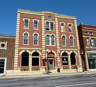
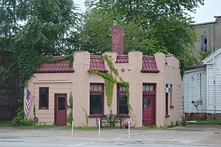
The Grand Hotel is a historic hotel in New Ulm, Minnesota, United States. The private, commercial structure was placed on the National Register of Historic Places (NRHP) on June 21, 1990. The building is notable because of its association with the development of New Ulm's business district and as an example of Italianate architecture in a commercial building.

Moline Downtown Commercial Historic District

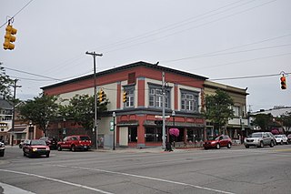
The Moline Downtown Commercial Historic District is a nationally recognized historic district located in Moline, Illinois, United States. Centered on 5th Avenue, it is roughly bounded by 12th Street to 18th Street, 4th Avenue to 7th Avenue. The distinct covers 33-acre (0.13 km2) and includes 114 buildings. One hundred of the buildings contribute to the significance of the district because they retain their historic and architectural integrity and reflect the character of the historic downtown.

Main Street Historic District (Milan, Michigan) historic district in Milan, Michigan

The Main Street Historic District is a commercial historic district that includes structures located at 3-153 East Main Street, 1-41 West Main Street, and 8 Park Lane in Milan, Michigan. Although within Milan, the district spans the county line between Washtenaw County, Michigan and Monroe County, Michigan, containing structures within both counties. It was listed on the National Register of Historic Places in 1999.

Ithaca Downtown Historic District (Ithaca, Michigan)

The Ithaca Downtown Historic District is a commercial historic district located on East Center Street, between Main and Pine River, in Ithaca, Michigan. It was listed on the National Register of Historic Places in 2005.

Iron Mountain Central Historic District

The Iron Mountain Central Historic District is a historic district, broadly located between Fleshiem and C Streets and between Iron Mountain and Stockbridge Avenues in Iron Mountain, Michigan. The district covers the city's central business district and adjacent areas. It is primarily commercial, but also contains the historic county courthouse complex, and school, library, and church buildings. It was listed on the National Register of Historic Places in 2013.

La Harpe Historic District

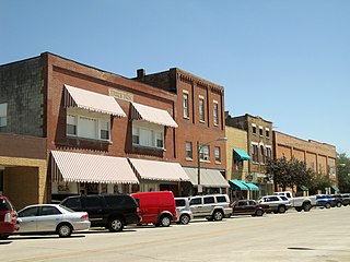
The La Harpe Historic District is a historic district located in downtown La Harpe, Illinois. The district, which is primarily commercial, includes the 100 East and 100 West blocks of Main Street and the 100 South block of Center Street. While La Harpe was settled in the 1830s, most of its development took place after railroad service came to the city in 1865. The city became a regional service center for the surrounding agricultural areas, and the commercial buildings constructed during this late 19th century economic boom form the core of the district. The buildings are primarily red brick commercial structures, some of which have decorative storefronts; the three outliers are a frame house, an Italianate commercial building, and a Mission Revival gas station from the early twentieth century. La Harpe's economy and population stabilized after 1900, and the district has remained mostly unchanged since.

Clare Downtown Historic District

The Clare Downtown Historic District is a collection of 51 buildings located along four blocks of North McEwan Street in Clare, Michigan, along with adjacent portions of East and West Fourth Street and East and West Fifth Street. Street addresses of the structures run from 307 to 622 North McEwan, 114-120 East Fifth Street, 102-202 West Fifth Street, 112-115 East Fourth Street, and 112-124 West Fourth Street. The district was listed on the National Register of Historic Places in 2016.

Cedar Rapids Central Business District Commercial Historic District

The Cedar Rapids Central Business District Commercial Historic District is a nationally recognized historic district located in Cedar Rapids, Iowa, United States. It was listed on the National Register of Historic Places in 2015. At the time of its nomination it consisted of 60 resources, which included 46 contributing buildings, one contributing structure, 12 non-contributing buildings, and one non-contributing structure. Cedar Rapids was platted on the east bank of the Cedar River as Rapids City in 1841, and it was incorporated under the same name in 1849. Kingston was established on the west bank of the river in 1852. The two smaller communities consolidated in 1870 as Cedar Rapids. The streets were laid out parallel and perpendicular to the river, which flowed from the northwest to the southeast. The Chicago, Iowa and Nebraska Railroad was the first to arrive in the community in 1859 and the tracks were laid on Fourth Street on the eastern edge of the central business district. The first bridge across the river was built at Third Avenue in 1871.

Ionia Downtown Commercial Historic District

The 'Ionia Downtown Commercial Historic District is a primarily commercial district located roughly along West Main and Washington Streets, from Dexter Street to Library Street, in Ionia, Michigan. The district was listed on the National Register of Historic Places in 1984.

Portland Downtown Historic District historic district in Michigan, United States

The Portland Downtown Historic District is a primarily commercial historic district located along Kent and Maple Streets, between Academy Street and the Looking Glass River, in Portland, Michigan. It was listed on the National Register of Historic Places in 2005.

References