Related Research Articles

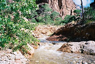
Supai is a census-designated place (CDP) in Coconino County, Arizona, United States, within the Grand Canyon.

The Grand Canyon of the Yellowstone is the first large canyon on the Yellowstone River downstream from Yellowstone Falls in Yellowstone National Park in Wyoming. The canyon is approximately 24 miles (39 km) long, between 800 and 1,200 ft deep and from .25 to .75 mi wide.
The Clear Creek Trail is a hiking trail below the North Rim, from lower Bright Angel Canyon into lower Clear Creek Canyon of the Grand Canyon National Park, located in the U.S. state of Arizona.
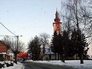
Dubrava is a village and a municipality ("općina") in Zagreb County, Croatia.

The Cook–Folsom–Peterson Expedition of 1869 was the first organized expedition to explore the region that became Yellowstone National Park. The privately financed expedition was carried out by David E. Folsom, Charles W. Cook and William Peterson of Diamond City, Montana, a gold camp in the Confederate Gulch area of the Big Belt Mountains east of Helena, Montana. The journals kept by Cook and Folsom, as well as their personal accounts to friends were of significant inspirational value to spur the organization of the Washburn-Langford-Doane Expedition which visited Yellowstone in 1870.

The Trout River is a 20-mile-long (32 km) tributary of the St. Johns River in Duval County, Florida. Located entirely within Jacksonville's Northside area, the river is brackish in its lower section. The widest point of the river is near the St. Johns River, where it is 0.6 miles (1.0 km) across. The Trout River has wetlands as far as the mouth of the river's longest tributary, the Ribault River.

Olympic Hot Springs is located in Olympic National Park, Washington, United States. The springs contain 21 seeps near Boulder Creek, a tributary of the Elwha River. The temperature varies from lukewarm to 138 °F (59 °C).

The Grand Loop Road is a historic district which encompasses the primary road system in Yellowstone National Park. Much of the 140-mile (230 km) system was originally planned by Captain Hiram M. Chittenden of the US Army Corps of Engineers in the early days of the park, when it was under military administration. The Grand Loop Road provides access to the major features of the park, including the Upper, Midway and Lower geyser basins, Mammoth Hot Springs, Tower Fall, the Grand Canyon of the Yellowstone and Yellowstone Lake.

Dragoon National Forest was established in Arizona on May 25, 1907, with 69,120 acres (280 km2). On July 1, 1908, it was combined with Santa Catalina National Forest and Santa Rita National Forest to create Coronado National Forest. The name was discontinued.

Salmon Inlet, formerly Salmon Arm, is a fjord branching east from Sechelt Inlet in the British Columbia, Canada. Its companion, Narrows Inlet, another side-inlet of Sechelt Inlet, lies roughly 10 km (6.2 mi) north. Misery and Sechelt Creeks flow freely into the inlet, while the Clowhom River flows in from the artificial Clowhom Lake, formed by a small hydroelectric power development. The fjord is 23 km (14 mi) long; Clowhom Lake, covering a waterfall on the Clowhom River, stretches a further 12 km (7.5 mi) to the western base of Mount Tantalus, which is best known from the direction of Squamish and the Cheakamus Canyon stretch of British Columbia Highway 99. Heavily affected by logging and milling operations, the inlet is split almost into two portions by an alluvial fan spreading from the mouth of Sechelt Creek.
Minnie Maud is the name of a creek and canyon in eastern Utah that is noted as the western starting point of the Ninemile Canyon petroglyphs section. Minnie Maud Creek is a stream whose headwaters begin where the West Tavaputs Plateau and Wasatch Plateau meet the Uinta Mountains.
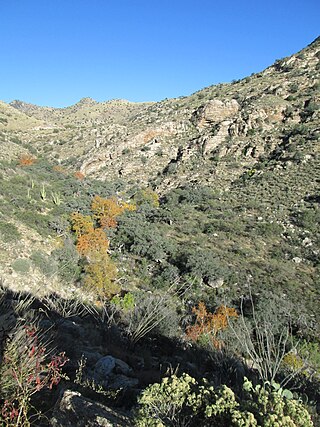
Molino Canyon is a steep-sided, boulder-strewn canyon in the Santa Catalina Mountains northeast of Tucson, Arizona, next to the Molino Basin Campground. The canyon is located within the Coronado National Forest, and encompasses a wide variety of flora and fauna, ranging from lush pine forest in the canyon's upper reaches to Sonoran Desert cactus forest in the lower reaches. Catalina Highway was cut into the western side of the lower part of the canyon.
Butterfield Valley is a valley along the course of Temecula Creek, in Riverside County, California. Its lower end is now filled by Vail Lake. It heads at 33°27′39″N116°55′34″W and its mouth is at the site of the Vail Lake Dam at the head of the deep canyon Temecula Creek has cut through Oak Mountain to the Pauba Valley.

Laguña Creek also formerly also known as Tyende Creek, is a stream in the Navajo and Apache Counties of Arizona. Laguña Creek has its source at 36°41′15″N110°30′36″W, at the confluence of Long Canyon and Dowozhiebito Canyon at an elevation of 6,325 feet at the head of Tsegi Canyon. Its mouth is in the Chinle Valley at its confluence with Chinle Wash which together forms Chinle Creek, at an elevation of 4,774 feet. Chinle Creek is a tributary of San Juan River which is in turn a tributary of the Colorado River.
Tsegi Canyon is a canyon in Navajo County, Arizona. Tsegi, meaning in between the rocks, is a Navajo descriptive term for deep canyons with sheer walls. Laguña Creek has its headwaters at the head of Tsegi Canyon at 36°41′11″N110°30′33″W, where the creeks from Long Canyon and Dowozhiebito Canyon merge at an elevation of 6,325 feet (1,928 m). The canyon mouth is located at elevation of 6,024 feet (1,836 m) near Marsh Pass.
Long Canyon is a canyon in Navajo County, Arizona. The head of Long Canyon is at 36°50′04″N110°28′08″W. Laguña Creek has its headwaters at the mouth of Long Canyon, where the creeks from Long Canyon and Dowozhiebito Canyon have their confluence at an elevation of 6,322 feet at the head of Tsegi Canyon.
Volger Branch is a stream in Atchison County in the U.S. state of Missouri. It is a tributary of Rock Creek.
White Bear is an unincorporated community in Marion County, in the U.S. state of Missouri.
Ashley Creek is an unincorporated community in northeastern Texas County, in the U.S. state of Missouri. The community is located along South Ashley Creek, approximately 1.5 miles south of its confluence with North Ashley Creek to form Ashley Creek. The community is on a sharp meander of the stream and Ashley Creek church and cemetery are about one mile downstream. Montauk State Park on Pigeon Creek is about three miles to the north in Dent County.
Smittle is an unincorporated community in northwestern Wright County, in the U.S. state of Missouri. The community was located on Missouri Route TT, approximately five miles east of Grovespring and one half mile west of Elk Creek. The historic Mt. Olive School was just north of the village.
References
Coordinates: 36°41′19″N110°30′36″W / 36.68861°N 110.51000°W
| | This article relating to the Navajo Nation is a stub. You can help Wikipedia by expanding it. |