Related Research Articles
Draco is the Greco-Latin word for serpent, or dragon.
The Victoria Cross Ranges are a set of mountain ranges in the Canadian Rockies, located to the northwest of Jasper. Of the 19 peaks contained within this range, five are named after Canadian recipients of the Victoria Cross. The area of the ranges is 678 square kilometres (262 sq mi).

Monarch Mountain is one of the principal summits of the Pacific Ranges subdivision of the Coast Mountains in southern British Columbia. It stands just east of a pass between the Klinaklini River and the south branch of the Atnarko River, which is a tributary of the Bella Coola River. Surrounding Monarch Mountain is the Monarch Icefield, the northernmost of the major icefields of the Pacific Ranges, and just south of it is the Ha-Iltzuk Icefield, which is the largest. Monarch is in the southern end of Tweedsmuir South Provincial Park.

Division No. 18 is a census division in Alberta, Canada. It is located in the southeast corner of northern Alberta and its largest urban community is the Hamlet of Grande Cache. The boundaries of the division are coextensive with the outer boundaries of the Municipal District of Greenview No. 16.

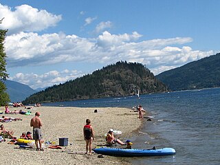
Shuswap Lake Provincial Park is a provincial park in British Columbia, Canada. It is located in the community of Scotch Creek, on the north shore of the main arm of Shuswap Lake in the Southern Interior of BC. The park is about 45 minutes north of Salmon Arm, and about 1 hour east of Kamloops. The park contains a large campground with approximately 275 camping sites, as well as a large sand and gravel beach and day use/picnic area. It is a very popular park, with many thousands of people, primarily from BC and Alberta, camping there every year.
Mount Sir MacKenzie Bowell is a 3,301 m (10,830 ft) mountain peak located at co-ordinates 52°49′54″N119°43′48″W in the Premier Range of the Cariboo Mountains in the east-central interior of British Columbia, Canada. The mountain is located between the Kiwa and Tete glaciers.
Mount Richard Bennett is a 3,190 m (10,466 ft) peak located at co-ordinates 52°49′48″N119°47′36″W in the Premier Range of the Cariboo Mountains in the east-central interior of British Columbia, Canada. The mountain is just north of the taller Mount Sir John Abbott and is often considered a continuation of that mountain.

Cherhill is a hamlet in Alberta, Canada within Lac Ste. Anne County. It is located along Highway 43, approximately 35 kilometres (22 mi) east of Mayerthorpe and 82 kilometres (51 mi) northwest of Edmonton.
La Glace is a hamlet in northern Alberta, Canada within the County of Grande Prairie No. 1. It is located along Highway 59 between Sexsmith and Valhalla Centre and has an elevation of 735 metres (2,411 ft).
Blackmud Creek is a creek in Edmonton that flows into Whitemud Creek. The creek starts at Saunders Lake East of Nisku and runs northwest into the City, joining Whitemud Creek in the neighbourhood of Twin Brooks.
Carcajou Pass is a mountain pass on the Continental Divide and British Columbia–Alberta boundary at the north end of Mount Robson Provincial Park. On the Alberta side lies the northwestern part of Jasper National Park. Carcajou is the French word for "wolverine".
Armena is a hamlet in Alberta, Canada within Camrose County. It is located approximately 21 kilometres (13 mi) northwest of Camrose along Highway 21 and has an elevation of 745 metres (2,444 ft).
Driftpile is a community on the Drift Pile River 150 Indian reserve, in northern Alberta, Canada. It is located on Highway 2, approximately 191 kilometres (119 mi) east of Grande Prairie.
Mount Bulyea is located in Banff National Park on the border of Alberta and British Columbia. It was named in 1920 after Hon. George H. V. Bulyea, a Canadian Pacific Railway employee and first Lieutenant Governor of Alberta.

Alexis 133 is an Indian reserve of the Alexis Nakota Sioux Nation in Alberta, located within Lac Ste. Anne County. It is 70 kilometres northwest of Edmonton. In the 2016 Canadian Census, it recorded a population of 755 living in 173 of its 209 total private dwellings.
Casket Mountain is a summit in Alberta, Canada.
Chetang Ridge is a ridge in Alberta, Canada.
Conjuring Creek is a stream in Alberta, Canada, and is a minor tributary of the North Saskatchewan River. It originates at Wizard Lake and drains into the North Saskatchewan River. It runs from south to north passing through the town of Calmar.

Dragon Peak is a 2,880 metres (9,450 ft) mountain summit located in the Athabasca River valley of Jasper National Park, in the Canadian Rockies of Alberta, Canada. Situated southeast of Mount Christie and Brussels Peak, Dragon Peak can be seen from the Icefields Parkway. The first ascent of the mountain was made in 1979 by D. Waterman. Dragon Peak was named in 1921 by Arthur O. Wheeler on account of a dragon-shaped rock formation. The mountain's name was officially adopted in 1935 by the Geographical Names Board of Canada.
The Hump is a summit in Alberta, Canada.
References
- ↑ "Draco Peak". Geographical Names Data Base . Natural Resources Canada.
- ↑ Place-names of Alberta. Ottawa: Geographic Board of Canada. 1928. p. 44.