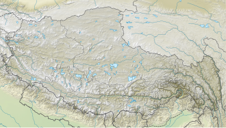
Dragmarpo Ri | |
---|---|
Highest point | |
Elevation | 6,578 m (21,581 ft) |
Prominence | 808 m (2,651 ft) |
Listing | List of mountains in Nepal |
Coordinates | 28°17′47″N85°40′00″E / 28.29639°N 85.66667°E Coordinates: 28°17′47″N85°40′00″E / 28.29639°N 85.66667°E |
Geography | |
Location | Langtang, Nepal - Tibet, China |
Parent range | Himalayas |
Climbing | |
First ascent | not climbed |
Dragmarpo Ri is a mountain on the border between Nepal and People's Republic of China. [1]
The peak is located at 6,200 m (20,300 ft) above sea level. The prominence is 235 m (771 ft). [2]
High Rock Range is a mountain range of the Canadian Rockies in southwestern Alberta and southeastern British Columbia, Canada.
Gokyo Peak is a 5,357 m (17,575 ft)-high peak in the Khumbu region of the Nepal Himalayas. It is located on the west side of the Ngozumpa glacier, which is the largest glacier in Nepal and reputed to be the largest in the whole Himalayas. Gokyo, at the base of Gokyo Ri, is a small hamlet of a few stone houses and one of the highest settlements in the world. From the summit of Gokyo Ri it is possible to see four 8,000-metre peaks: Mount Everest, Lhotse, Makalu and Cho Oyu. The Gokyo Lakes are in the area.
Yala Peak is a mountain in the Langtang area in Nepal.
The Actual Ground Position Line (AGPL) divides current positions of Indian and Pakistani military posts and troops across the entire 110 kilometres (68 mi) long front line in the disputed region of Siachen Glacier. AGPL generally runs along the Saltoro Mountains range, beginning from the northernmost point of the (LOC) at Point NJ 9842 and ending in the north on the Indira Ridge at the India-China-Pakistan LAC tripoint near Sia Kangri about 4 km northwest of Indira Col West, with peaks in excess of 7,000 meters and temperatures ranging to around minus 55 Celsius. India gained control of 1,000 square miles (2,600 km2) of disputed territory in 1984 because of its military operations in Siachen. A cease-fire was announced in 2003.
Gokyo Lakes are oligotrophic lakes in Nepal's Sagarmatha National Park, located at an altitude of 4,700–5,000 m (15,400–16,400 ft) above sea level. Lakes and resort were named after Gokyo Ri peak. These lakes are the world's highest freshwater lake system comprising six main lakes, of which Thonak Lake is the largest. In September 2007, Gokyo and associated wetlands of 7,770 ha (30.0 sq mi) have been designated a Ramsar site.
Kunturiri is a mountain in the Cordillera Real of Bolivia, about 5,648 metres (18,530 ft) high. It is also the name of the whole massif. Kunturiri is located in the La Paz Department, Los Andes Province, Pukarani Municipality, southeast of Chachakumani and northwest of Huayna Potosí.
Sarwali Peak, also known as Dabbar Peak and Toshe Ri is actually Toshain-I which at an altitude of 6,326 metres (20,755 ft) above sea level at the junction of the Neelam and Shounter Valleys in Pakistan administered Kashmir, Pakistan at on Toshain/Rupal Glacier towering in Rupal Valley of Nanga Parbat. It is the highest point in Pakistan administered Kashmir. The Kashmir Tourism Department sent an expedition in 2004, but there has been no documented successful ascent of the peak. The ridge line that forms Toshain walls houses Toshain II, Toshain III, Toshain IV and Toshain V, which all are technical in nature and heavily glaciated. Three Islamabad based climbers named Imran Juanidi, Usman Tariq and Khurram Rajput tried to reach the summit but went missing on 31 August 2015 and, despite search and rescue effort, could not be found.
Porong Ri is a mountain in the Langtang region of the Himalayas. At 7,292 m (23,924 ft) it is the 86th highest mountain in the world. The peak is located in Tibet, China, at about one kilometre northeast of the Nepal border.
Langtang Ri is a mountain in the Langtang Himal of the Himalayas. At an elevation of 7,205 m (23,638 ft) it is the 106th highest mountain in the world. Located on the border between the Bagmati Zone of Nepal and Tibet, China, it is part of a group of high peaks that include Shishapangma and Porong Ri.
Chandra Parbat South is a mountain of the Garhwal Himalaya in Uttarakhand India. It's the lowest among three peak's in the Chandra Massif. It is situated in the Gangotri National Park. The elevation of Chandra Parbat (South) is 6,557 metres (21,512 ft) and its prominence is 115 metres (377 ft). It is joint 74th highest located entirely within the Uttrakhand. Nanda Devi, is the highest mountain in this category. It lies 1.3 km SSW of Chandra Parbat I 6,739 metres (22,110 ft) its nearest higher neighbor. Satopanth 7,075 metres (23,212 ft) lies 4.1 km WSW and it is 6.2 km NNE of Swachhand 6,721 metres (22,051 ft). It lies 7.7 km east of Vasuki Parbat South 6,702 metres (21,988 ft).
P. 6504 is a mountain of the Garhwal Himalaya in Uttarakhand, India. It is also known as Satopanth West. It is situated in the Gangotri National Park. The elevation of P. 6504 is 6,504 metres (21,339 ft). It is joint 88th highest located entirely within the Uttrakhand. Nanda Devi, is the highest mountain in this category. It lies 3 km SSE of Bhagirathi Parbat I 6,856 metres (22,493 ft). Satopanth 7,075 metres (23,212 ft) lies 5.8 km ENE and it is 6.7 km WNW of Swachhand 6,721 metres (22,051 ft). It lies 8.1 km ENE of Kedarnath Dome 6,831 metres (22,411 ft).
Spangnak Ri is a mountain peak located at 6,390 m (20,960 ft) above sea level in the far west of the Transhimalaya.
Summa Ri is are two of the sub-peaks of Skil Brum in the Hindu Kush-Karakoram range. It is on the border between Gilgit-Baltistan region of Pakistan-administered Kashmir and Xinjiang Autonomous Region in the China.
Skyampoche Ri is a mountain peak located at 7,016 m (23,018 ft) above sea level in the far west of the Transhimalaya.
Chong Kumdang Ri(or Chong Kumdang Ri I & II) are two of the highest mountains in the mountain group which are located in the north of Mamostong Kangri in Rimo Karakoram sub-range in the west of the Transhimalaya.
La Yongma Ri s a mountain peak located at 6,826 m (22,395 ft) above sea level in the southern main ridge of the Saltoro Mountains, a sub-range of the Karakorum.
Pologongka is a mountain peak located at 6,390 m (20,960 ft) above sea level in the Indian territory of Ladakh, far west of the Transhimalaya.
Gharkun is a mountain peak located at 6,521 m (21,394 ft) above sea level in the west of the Saltoro Mountains, part of Karakorum Range.
Gyong Kangri is a mountain peak located at 6,727 m (22,070 ft) above sea level, near the north end of the Saltoro Mountains, a subrange of the Karakoram range.
Tsangbu Ri is a mountain peak in the Himalayas, located on the border of Bagmati Province of Nepal and the Tibet Autonomous Region of China.