
With an area of 238,397 km2 (92,046 sq mi), Romania is the twelfth-largest country in Europe. It is a Balkan country located at the crossroads of Eastern and Southeast Europe. It's bordered on the Black Sea, the country is halfway between the equator and the North Pole and equidistant from the westernmost part of Europe—the Atlantic Coast—and the most easterly—the Ural Mountains. Romania has 3,195 kilometres (1,985 mi) of border. Moldova and Ukraine lie to the east, Bulgaria to the south, and Serbia and Hungary to the west by the Pannonian Plain. In the southeast, 245 kilometres (152 mi) of sea coastline provide an important outlet to the Black Sea and the Atlantic Ocean.

The Carpathian Mountains or Carpathians are a range of mountains forming an arc across Central Europe and Southeast Europe. Roughly 1,500 km (930 mi) long, it is the third-longest European mountain range after the Urals at 2,500 km (1,600 mi) and the Scandinavian Mountains at 1,700 km (1,100 mi). The range stretches from the far eastern Czech Republic (3%) and Austria (1%) in the northwest through Slovakia (21%), Poland (10%), Ukraine (10%), Romania (50%) to Serbia (5%) in the south. The highest range within the Carpathians is known as the Tatra Mountains in Poland and Slovakia, where the highest peaks exceed 2,600 m (8,500 ft). The second-highest range is the Southern Carpathians in Romania, where the highest peaks range between 2,500 m (8,200 ft) and 2,550 m (8,370 ft).
UNESCO Biosphere Reserves are environment-protected scientific-research institutions of international status that are created with the intent for conservation in a natural state the most typical natural complexes of biosphere, conducting background ecological monitoring, studying of the surrounding natural environment, its changes under the activity of anthropogenic factors.

Ivano-Frankivsk Oblast, also referred to as Ivano-Frankivshchyna (Івано-Франківщина) or simply Frankivshchyna, is an oblast (region) in western Ukraine. Its administrative center is the city of Ivano-Frankivsk. It has a population of 1,351,822.
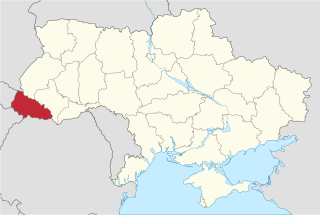
Zakarpattia Oblast, also referred to as simply Zakarpattia or Transcarpathia in English, is an oblast located in the Carpathian Mountains in west Ukraine, mostly coterminous with the historical region of Carpathian Ruthenia. Its administrative centre is the city of Uzhhorod. Other major cities within the oblast include Mukachevo, Khust, Berehove, and Chop, the last of which is home to railroad transport infrastructure.

Cindrel Mountains are a group of mountains in central Romania in the centre of the Southern Carpathians, in the North-East of the Parâng Mountains group.

Chornohora is the highest mountain range in Western Ukraine. It is within the Polonynian Beskids, a subgroup of the mountain group of Eastern Beskids, which in turn is part of the Outer Eastern Carpathians.

Magura National Park is a National Park located in the south-east of Poland, close to Slovakia, on the boundary of Lesser Poland Voivodeship and Subcarpathian Voivodeship. It covers the main part of the upper basin of the Wisłoka river. When the park was created in 1995 it covered 199.62 km2, although it is now only 194.39 km2 (75.05 sq mi), of which 185.31 km2 is forest.

Poloniny National Park is a national park in northeastern Slovakia at the Polish and Ukrainian borders, in the Bukovské vrchy mountain range, which belongs to the Eastern Carpathians. It was created on 1 October 1997 with a protected area of 298.05 km2 (115.08 sq mi) and a buffer zone of 109.73 km2 (42.37 sq mi). Selected areas of the park are included into Primeval Beech Forests of the Carpathians UNESCO World Heritage Site.

Devínska Kobyla is the highest peak in the Devín Carpathians, part of the Little Carpathians mountain range, and the highest point of Bratislava, the capital of Slovakia. It is located between the boroughs of Devínska Nová Ves, Devín and Dúbravka, close to the border with Austria. Its peak elevation is 514 m (1686.3 ft) AMSL and its treeless summit contains an abandoned military missile base that is officially inaccessible to the public.

The Buzău Mountains are a set of six mountains ranges in Romania which are part of the Curvature Carpathians region of the Outer Eastern Carpathians.
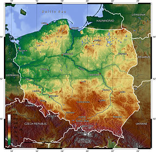
Poland is a country that extends across the North European Plain from the Sudetes and Carpathian Mountains in the south to the sandy beaches of the Baltic Sea in the north. Poland is the fifth-most populous country of the European Union and the ninth-largest country in Europe by area. The territory of Poland covers approximately 312,696 km2 (120,733 sq mi), of which 98.52% is land and 1.48% is water. The Polish coastline was estimated at 770 km (478 mi) in length. Poland's highest point is Rysy, at 2,500 m (8,202 ft).

The Ukrainian Carpathians are a section of the Eastern Carpathians, within the borders of modern Ukraine. They are located in the southwestern corner of Western Ukraine, within administrative territories of four Ukrainian regions (oblasts), covering northeastern part of Zakarpattia Oblast, southwestern part of Lviv Oblast, southern half of Ivano-Frankivsk Oblast and western half of Chernivtsi Oblast.
The Svydovets is a mountain range in western Ukraine, one of the ranges of Eastern Beskids, itself belonging to the Outer Eastern Carpathians. It is a biodiversity hotspot in the Ukrainian Carpathians. The territories of the Svydovets mountain range belong to the state. The highest peak of the range is Blysnyzi mountain. The Black Tisza, the source of Tisza, is one of the more fullflowing rivers of the region, it flows out from the Svydovets.
Carpathian Biosphere Reserve is a biosphere reserve in Ukraine that was established in 1968 and became part of the World Network of Biosphere Reserves of UNESCO in 1992. Since 2007 bigger portion of the reserve along with some territories of the Uzh River National Park was listed with the UNESCO World Heritage Sites as part of the Ancient and Primeval Beech Forests of the Carpathians and Other Regions of Europe.

The Sanok-Turka Mountains are a mountain range in the Eastern Beskids, within the Outer Eastern Carpathians. They are located in southern border section between Poland and Ukraine.

The Carpathian National Nature Park is a National Park located in Ivano-Frankivsk Oblast, Ukraine. The park was established on 3 June 1980 to protect landscapes of the Carpathian Mountains. The headquarters of the park are in Yaremche. Carpathian National Nature Park is the first national park of Ukraine and one of the biggest national parks of the country.

Kobula is a mountain in the Ukrainian Carpathians within Rakhiv district of Transcarpathian region.

Svydovets protected massif Ukrainian: Свидовецький заповідний масив is a protected area in the Ukrainian Carpathians near Rakhiv in the Zakarpattya region. The protected massif has an area of 6,580 hectares and is located at an elevation of 600–1883 m.a.s.l. in the highest region of the Svydovets mountain range.

Verkhovyna National Nature Park is a national park of Ukraine that covers the highest reaches of the Cheremosh River, in the Carpathian Mountains. The park is in the administrative district of Verkhovyna in Ivano-Frankivsk Oblast; the nearest city is Chernivtsi.

