Dragoman Municipality

Last updated
Dragoman Municipality

Община Драгоман
Map of Dragoman municipality (Sofia Province).png
CountryFlag of Bulgaria.svg  Bulgaria
Province Sofia Province
Seat Dragoman

Dragoman Municipality is a municipality in Sofia Province, Bulgaria.

Sofia Province Province in Bulgaria

Sofia Province is a province (oblast) of Bulgaria. The province does not include Sofia in its territories, but Sofia remains its administrative center. The province borders on the provinces of Pernik, Kyustendil, Blagoevgrad, Pazardzhik, Plovdiv, Lovech, Vratsa, Montana and "Sofia-Capital", to the northwest there is border with Serbia.

Bulgaria country in Southeast Europe

Bulgaria, officially the Republic of Bulgaria, is a country in Southeast Europe. It is bordered by Romania to the north, Serbia and North Macedonia to the west, Greece and Turkey to the south, and the Black Sea to the east. The capital and largest city is Sofia; other major cities are Plovdiv, Varna and Burgas. With a territory of 110,994 square kilometres (42,855 sq mi), Bulgaria is Europe's 16th-largest country.

Contents

Demography

According to the 2011 census, there are 5,362 people living in the municipality of Dragoman, down from 17,187 people in 1934. Most inhabitants live in the town of Dragoman (3,368 people), followed by the villages of Gaber (541 people) and Kalotina (250 people).

Dragoman, Bulgaria Town in Sofia, Bulgaria

Dragoman is the seat of Dragoman Municipality in the Sofia Province, western Bulgaria. The town is located very close to the border with Serbia. As of 2011 the population is 5,362.

Gaber is a village in Dragoman Municipality, Sofia Province, western Bulgaria.

Kalotina Place in Sofia, Bulgaria

Kalotina is a village in Dragoman Municipality, Sofia Province, in westernmost central Bulgaria. As of 2010 it has 270 inhabitants and the mayor is Lidia Bozhilova. The village is located at the border with Serbia, 55 km to the northwest of the capital Sofia, on the main highway and railway between Western Europe and Asia. Kalotina lies at 42°59′N22°52′E, 282 metres above sea level. Kalotina is known for the Kalotina-Gradinje border checkpoint, one of Bulgaria's busiest and best-known due to the proximity to Sofia. The Nishava River, a tributary of the South Morava, flows nearby.

Religion

According to the latest Bulgarian census of 2011, the religious composition, among those who answered the optional question on religious identification, was the following:

Religious composition of Dragoman Municipality [1]
Orthodox Christianity
93.0%
Catholicism
0.3%
Protestantism
0.2%
Islam
0.1%
No religion
2.0%
Prefer not to answer, others and indefinable
4.4%

Related Research Articles

Sopot Municipality is a municipality in Plovdiv Province, Bulgaria. The municipality consists only of two places: the town of Sopot and the village of Anevo.

Chelopech Place in Sofia, Bulgaria

Chelopech is a village in the western part of Bulgaria. It is the only village in the Chelopech Municipality, Sofia Province.

Roman Municipality Municipality in Vratsa Province, Bulgaria

Roman Municipality is a municipality in Vratsa Province, Bulgaria.

Anton Municipality Municipality in Sofia Province, Bulgaria

Anton Municipality is located in Sofia Province, Bulgaria. The administrative centre is in Anton, Bulgaria.

Chavdar Municipality Municipality in Sofia Province, Bulgaria

Chavdar Municipality is one of the municipalities in Sofia Province, Bulgaria. The seat is at Chavdar, Sofia Province.

Chelopech Municipality Municipality in Sofia Province, Bulgaria

Chelopech Municipality is a municipality in Sofia Province, Bulgaria.

Koprivshtitsa Municipality Municipality in Sofia Province, Bulgaria

Koprivshtitsa Municipality is a municipality in Sofia Province, Bulgaria. The only settlement and administrative center of the municipality is Koprivshtitsa.

Donja Nevlja Village in Pirot District, Serbia

Donja Nevlja is a village in the municipality of Dimitrovgrad, Serbia and in municipality of Dragoman, Bulgaria. According to the 2002 Serbian census, the village has a population of 31 people. According to the 2014 data of the Bulgarian Citizen Registry, the village has a population of 2

Velingrad Municipality is the largest municipality in Pazardzhik Province, Bulgaria. The municipality consists of two towns, Velingrad and Sarnitsa as well as 22 villages, with a total population of 40,595.

Yakoruda Municipality Municipality in Blagoevgrad, Bulgaria

Yakoruda Municipality is a municipality in Blagoevgrad Province in southwestern Bulgaria.

Burgas Municipality Municipality in Burgas, Bulgaria

Burgas Municipality is the most populated municipality in Burgas Province. It includes Burgas, the town of Balgarovo and 12 villages. After a referendum in 2011 Izvor became part of Burgas Municipality.

Aytos Municipality Municipality in Burgas, Bulgaria

Aytos Municipality is a municipality in Burgas Province, Bulgaria. It includes the town of Aytos and 16 villages.

Ruen Municipality Municipality in Burgas, Bulgaria

Ruen Municipality is a municipality in Burgas Province, Bulgaria. It includes the town of Ruen and a number of villages.

Karnobat Municipality Municipality in Burgas, Bulgaria

Karnobat Municipality is a municipality in Burgas Province, Bulgaria. It includes the town of Karnobat and a number of villages.

Sredets Municipality Municipality in Burgas, Bulgaria

Sredets Municipality is a municipality in Burgas Province, Bulgaria. It includes the town of Sredets and 31 villages.

Sungurlare Municipality Municipality in Burgas, Bulgaria

Sungurlare Municipality is a municipality in Burgas Province, Bulgaria. It includes the town of Sungurlare and a number of villages with a total population of 12,559 as of 2011.

Tsarevo Municipality Municipality in Burgas, Bulgaria

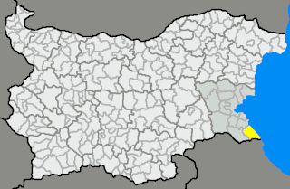
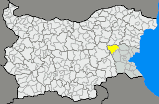
Tsarevo Municipality is a municipality in Burgas Province, Bulgaria.

Kameno Municipality Municipality in Burgas, Bulgaria

Kameno Municipality is a municipality in Burgas Province, Bulgaria. It includes the towns of Kameno and a number of villages.

Primorsko Municipality Municipality in Burgas, Bulgaria

Primorsko Municipality is a municipality in Burgas Province, Bulgaria. It includes the towns of Primorsko and Kiten as well as a number of villages.

References

  1. "Religious composition of Bulgaria 2011". pop-stat.mashke.org.

Coordinates: 42°55′19″N22°55′48″E / 42.9220°N 22.9301°E / 42.9220; 22.9301

Geographic coordinate system Coordinate system

A geographic coordinate system is a coordinate system that enables every location on Earth to be specified by a set of numbers, letters or symbols. The coordinates are often chosen such that one of the numbers represents a vertical position and two or three of the numbers represent a horizontal position; alternatively, a geographic position may be expressed in a combined three-dimensional Cartesian vector. A common choice of coordinates is latitude, longitude and elevation. To specify a location on a plane requires a map projection.