Drence

Last updated
Drence
Village
Serbia adm location map.svg
Red pog.svg
Drence
Coordinates: 42°55′56″N21°30′38″E / 42.93222°N 21.51056°E / 42.93222; 21.51056
CountryFlag of Serbia.svg  Serbia
District Jablanica District
Municipality Medveđa
Population (2002)
  Total 149
Time zone CET (UTC+1)
  Summer (DST) CEST (UTC+2)

Drence is a village in the municipality of Medveđa, Serbia. According to the 2002 census, the village has a population of 149 people. [1]

Village Small clustered human settlement smaller than a town

A village is a clustered human settlement or community, larger than a hamlet but smaller than a town, with a population ranging from a few hundred to a few thousand. Though villages are often located in rural areas, the term urban village is also applied to certain urban neighborhoods. Villages are normally permanent, with fixed dwellings; however, transient villages can occur. Further, the dwellings of a village are fairly close to one another, not scattered broadly over the landscape, as a dispersed settlement.

Medveđa Town and municipality in Southern and Eastern Serbia, Serbia

Medveđa is a town and municipality located in the Jablanica District of southern Serbia. According to the 2011 census, the town has a population of 2,848 inhabitants, while the municipality has of 7,438 inhabitants.

Serbia Republic in Southeastern Europe

Serbia, officially the Republic of Serbia, is a country situated at the crossroads of Central and Southeast Europe in the southern Pannonian Plain and the central Balkans. The sovereign state borders Hungary to the north, Romania to the northeast, Bulgaria to the southeast, North Macedonia to the south, Croatia and Bosnia and Herzegovina to the west, and Montenegro to the southwest. The country claims a border with Albania through the disputed territory of Kosovo. Serbia's population is about seven million. Its capital, Belgrade, ranks among the oldest and largest citiеs in southeastern Europe.

Related Research Articles

This is a list of the extreme points of Estonia: the points that are farther north, south, east or west than any other location.

Gola, Trzebnica County Village in Lower Silesian, Poland

Gola is a village in the administrative district of Gmina Prusice, within Trzebnica County, Lower Silesian Voivodeship, in south-western Poland. Prior to 1945 it was in Germany.

Os de Civís Village in Catalonia, Spain

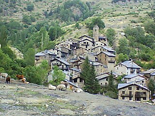
Os de Civís is a village in the central Pyrenees mountains, in the municipality of Les Valls de Valira in Catalonia, Spain, and is located to the west of Andorra, near the villages of Aixàs and Bixessarri. Civís is the nearest Spanish village. It is the most populated village in the municipality.

Gapa is a village in the administrative district of Gmina Kowalewo Pomorskie, within Golub-Dobrzyń County, Kuyavian-Pomeranian Voivodeship, in north-central Poland.

Zgłowiączka, Kuyavian-Pomeranian Voivodeship Village in Kuyavian-Pomeranian, Poland

Zgłowiączka is a village in the administrative district of Gmina Lubraniec, within Włocławek County, Kuyavian-Pomeranian Voivodeship, in north-central Poland. It lies approximately 5 kilometres (3 mi) south-west of Lubraniec, 24 km (15 mi) south-west of Włocławek, and 60 km (37 mi) south of Toruń.

Kozodawy Village in Lublin, Poland

Kozodawy is a village in the administrative district of Gmina Hrubieszów, within Hrubieszów County, Lublin Voivodeship, in eastern Poland, close to the border with Ukraine. It lies approximately 8 kilometres (5 mi) south-east of Hrubieszów and 110 km (68 mi) south-east of the regional capital Lublin.

Anielin, Kraśnik County Village in Lublin, Poland

Anielin is a village in the administrative district of Gmina Annopol, within Kraśnik County, Lublin Voivodeship, in eastern Poland. It lies approximately 7 kilometres (4 mi) north-east of Annopol, 22 km (14 mi) west of Kraśnik, and 58 km (36 mi) south-west of the regional capital Lublin.

Świeciechów Poduchowny Village in Lublin, Poland

Świeciechów Poduchowny is a village in the administrative district of Gmina Annopol, within Kraśnik County, Lublin Voivodeship, in eastern Poland. It lies approximately 6 kilometres (4 mi) north of Annopol, 26 km (16 mi) west of Kraśnik, and 62 km (39 mi) south-west of the regional capital Lublin.

Vanq Place in Khojavend, Azerbaijan

Vanq is a village in the Khojavend Rayon of Azerbaijan.

Belisli Place in Davachi, Azerbaijan

Belisli is a village in the Davachi Rayon of Azerbaijan.

Balin, Łódź Voivodeship Village in Łódź, Poland

Balin is a village in the administrative district of Gmina Poddębice, within Poddębice County, Łódź Voivodeship, in central Poland. It lies approximately 12 kilometres (7 mi) west of Poddębice and 48 km (30 mi) west of the regional capital Łódź.

Lubotyń-Morgi is a village in the administrative district of Gmina Stary Lubotyń, within Ostrów Mazowiecka County, Masovian Voivodeship, in east-central Poland.

Szlasy-Umiemy is a village in the administrative district of Gmina Krasne, within Przasnysz County, Masovian Voivodeship, in east-central Poland.

Komorowo Żuławskie Village in Warmian-Masurian, Poland

Komorowo Żuławskie is a village in the administrative district of Gmina Elbląg, within Elbląg County, Warmian-Masurian Voivodeship, in northern Poland. It lies approximately 8 kilometres (5 mi) east of Elbląg and 75 km (47 mi) north-west of the regional capital Olsztyn.

Belitsa, Sofia Province Village in Sofia Province, Bulgaria

Belitsa is a village (село) in southwestern Bulgaria, located in the Ihtiman Municipality of the Sofia Province.

Radosinj Village in Pirot, Serbia

Radosinj is a village in the municipality of Babušnica, Serbia. According to the 2002 census, the village has a population of 71 people.

Hosby is a village in Lääne-Nigula Parish, Lääne County, in western Estonia.

Kiviküla is a village in Ridala Parish, Lääne County, in western Estonia.

Aïn Bouchekif is a town and commune in Tiaret Province in northwestern Algeria.

Lozna (Trstenik) Village in Rasina District, Serbia

Lozna is a village in the municipality of Trstenik, Serbia. According to the 2002 census, the village has a population of 380 people.

References

  1. Popis stanovništva, domaćinstava i Stanova 2002. Knjiga 1: Nacionalna ili etnička pripadnost po naseljima. Republika Srbija, Republički zavod za statistiku Beograd 2003. ISBN   86-84433-00-9

Coordinates: 42°55′56″N21°30′38″E / 42.93222°N 21.51056°E / 42.93222; 21.51056

Geographic coordinate system Coordinate system

A geographic coordinate system is a coordinate system that enables every location on Earth to be specified by a set of numbers, letters or symbols. The coordinates are often chosen such that one of the numbers represents a vertical position and two or three of the numbers represent a horizontal position; alternatively, a geographic position may be expressed in a combined three-dimensional Cartesian vector. A common choice of coordinates is latitude, longitude and elevation. To specify a location on a plane requires a map projection.