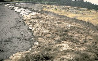
A lahar is a violent type of mudflow or debris flow composed of a slurry of pyroclastic material, rocky debris and water. The material flows down from a volcano, typically along a river valley.

Cook Inlet stretches 180 miles (290 km) from the Gulf of Alaska to Anchorage in south-central Alaska. Cook Inlet branches into the Knik Arm and Turnagain Arm at its northern end, almost surrounding Anchorage. On its southern end, it merges with Shelikof Strait, Stevenson Entrance, Kennedy Entrance and Chugach Passage.

Lake Clark National Park and Preserve is an American national park in southwest Alaska, about 100 miles (160 km) southwest of Anchorage. The park was first proclaimed a national monument in 1978, then established as a national park and preserve in 1980 by the Alaska National Interest Lands Conservation Act. The park includes many streams and lakes vital to the Bristol Bay salmon fishery, including its namesake Lake Clark. A wide variety of recreational activities may be pursued in the park and preserve year-round. The park protects rainforests along the coastline of Cook Inlet, alpine tundra, glaciers, glacial lakes, major salmon-bearing rivers, and two volcanoes, Mount Redoubt and Mount Iliamna. Mount Redoubt is active, erupting in 1989 and 2009. The wide variety of ecosystems in the park mean that virtually all major Alaskan animals, terrestrial and marine, may be seen in and around the park. Salmon, particularly sockeye salmon, play a major role in the ecosystem and the local economy. Large populations of brown bears are attracted to feed on the spawning salmon in the Kijik River and at Silver Salmon Creek. Bear watching is a common activity in the park.

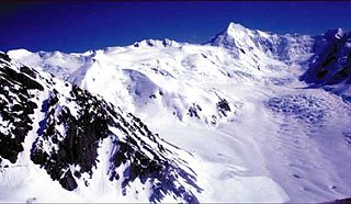
Redoubt Volcano, or Mount Redoubt, is an active stratovolcano in the largely volcanic Aleutian Range of the U.S. state of Alaska. Located at the head of the Chigmit Mountains subrange in Lake Clark National Park and Preserve, the mountain is just west of Cook Inlet, in the Kenai Peninsula Borough about 110 miles (180 km) southwest of Anchorage. At 10,197 feet (3,108 m), in just over 5 miles (8.0 km) Mount Redoubt attains 9,150 feet (2,790 m) of prominence over its surrounding terrain. It is the highest summit in the Aleutian Range. In 1976, Redoubt Volcano was designated as a National Natural Landmark by the National Park Service.

Augustine Volcano is a lava dome volcano in Alaska consisting of a central complex of summit lava domes and flows surrounded by an apron of pyroclastic, lahar, avalanche, and ash deposits. The volcano is frequently active, with major eruptions recorded in 1883, 1935, 1963–64, 1976, 1986, and 2006. Minor eruptive events were reported in 1812, 1885, 1908, 1944, and 1971. The large eruptions are characterized by an explosive onset followed by the quieter effusion of lava. It forms Augustine Island in southwestern Cook Inlet in the Kenai Peninsula Borough of southcentral coastal Alaska, 174 miles (280 km) southwest of Anchorage. Augustine Island has a land area of 32.4 square miles (83.9 km2), while West Island, just off Augustine's western shores, has 2 sq mi (5.2 km2). The irregular coastline of Augustine Island is due to the repeated catastrophic collapse of the summit dome, forming debris avalanches down the flanks and into Cook Inlet.
Hayes Volcano is a stratovolcano in southwestern Matanuska-Susitna Borough, Alaska, 135 km northwest of Anchorage, that was not discovered until 1975. It is responsible for a series of six major tephra layers in the Cook Inlet region of Alaska. Hayes was mostly destroyed by at least six catastrophic eruptions between 3,400 and 3,800 years ago, and the average volume of these eruptions was 2.4 cubic km. In comparison, the volume of the May 18, 1980 eruption of Mount St. Helens was about 1 cubic km. The eruptions of Hayes Volcano during that time were the most voluminous Holocene eruptions to have occurred in the Cook Inlet region. There is currently no fumarolic activity present. The last eruption of Hayes Volcano occurred roughly 1,200 years ago. It is named after the adjacent Hayes Glacier.

An oil terminal is an industrial facility for the storage of oil, petroleum and petrochemical products, and from which these products are transported to end users or other storage facilities. An oil terminal typically has a variety of above or below ground tankage; facilities for inter-tank transfer; pumping facilities; loading gantries for filling road tankers or barges; ship loading/unloading equipment at marine terminals; and pipeline connections.

The Llandarcy Oil Refinery, also known as the National Oil Refinery, BP Llandarcy and Skewen refinery, was the United Kingdom's first oil refinery, initially opened by the Anglo-Persian Oil Company on 29 June 1922, although operations had begun on 1 July 1921. Before this, the only oil refined in the UK came from Scottish shale.

The Teesside Refinery was an oil refinery and chemical plant situated just south of Seaton Carew on the River Tees in County Durham. In 2000, it was bought by Petroplus from ICI and Phillips Petroleum Company. Refining was suspended in 2009, although the site continues to operate as a terminal and storage facility.

An oil tanker, also known as a petroleum tanker, is a ship designed for the bulk transport of oil or its products. There are two basic types of oil tankers: crude tankers and product tankers. Crude tankers move large quantities of unrefined crude oil from its point of extraction to refineries. Product tankers, generally much smaller, are designed to move refined products from refineries to points near consuming markets.

The BPRefinery (Kent) was an oil refinery on the Isle of Grain in Kent. It was commissioned in 1953 and had a maximum processing capacity of 11 million tonnes of crude oil per year. It was decommissioned in August 1982.
The Trans-Panama Pipeline is an oil pipeline across Panama near the Costa Rican border from the port of Chiriqui Grande, Bocas del Toro on the Caribbean coast to the port of Charco Azul on the Pacific coast.

The Pembroke Refinery is an oil refinery situated on the Pembrokeshire coast in Wales at Rhoscrowther in the community of Angle. It first came on stream in 1964 and was Regent/Texaco's only British refinery. The refinery occupies a prominent position on the south bank of the Milford Haven Waterway and can be seen for many miles. Around a quarter of the site is within the Pembrokeshire Coast National Park which was created in 1952.

The Chevron Richmond Refinery is a 2,900-acre (1,200 ha) petroleum refinery in Richmond, California, on San Francisco Bay. It is owned and operated by Chevron Corporation and employs more than 1,200 workers, making it the city's largest employer. The refinery processes approximately 240,000 barrels (38,000 m3) of crude oil a day in the manufacture of petroleum products and other chemicals. The refinery's primary products are motor gasoline, jet fuel, diesel fuel and lubricants.

Alaska's Mount Redoubt volcano began erupting on March 22, 2009, and activity continued for several months.

The 1991 eruption of Mount Pinatubo in the Philippines' Luzon Volcanic Arc was the second-largest volcanic eruption of the 20th century, behind only the 1912 eruption of Novarupta in Alaska. Eruptive activity began on April 2 as a series of phreatic explosions from a fissure that opened on the north side of Mount Pinatubo. Seismographs were set up and began monitoring the volcano for earthquakes. In late May, the number of seismic events under the volcano fluctuated from day-to-day. Beginning June 6, a swarm of progressively shallower earthquakes accompanied by inflationary tilt on the upper east flank of the mountain, culminated in the extrusion of a small lava dome.
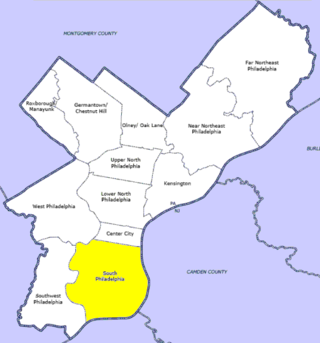
A refinery owned by Gulf Oil Corporation in Philadelphia, located at Girard Point on the Schuylkill River in South Philadelphia, caught fire on Sunday, August 17, 1975. This incident grew into an 11-alarm fire, not brought under control until 24 hours later, and resulted in the death of eight firefighters of the Philadelphia Fire Department (PFD), injuries to 14 other firefighters, and the loss of four PFD vehicles.

USCGC Sedge (WAGL-402/WLB-402) was an Iris-class 180-foot seagoing buoy tender operated by the United States Coast Guard. She served in the Pacific during World War II and in Alaska during the rest of her Coast Guard career. Sedge was decommissioned in 2002 and transferred to the Nigerian Navy where she is still active as NNS Kyanwa.
The Whitegate refinery, near Whitegate, County Cork, is Ireland's only oil refinery. It has a capacity of 75,000 barrels of oil per day (bpd), sufficient to provide 40 percent of Ireland's fuel requirements. It was commissioned in 1959 and was redeveloped several times and produces a range of petroleum products.

