
The Leicester and Swannington Railway (L&S) was one of England's first railways, being opened on 17 July 1832 to bring coal from collieries in west Leicestershire to Leicester.

Denniston is a small settlement, 15 kilometres east of Westport, on the West Coast of the South Island of New Zealand. It is situated on the Denniston Plateau, 600 metres (2,000 ft) above sea level in the Papahaua Ranges.

The Midland Railway – Butterley is a heritage railway at Butterley, near Ripley in Derbyshire.

Shildon is a town and civil parish in County Durham, in England. The population taken at the 2011 Census was 9,976. It is situated 2 miles (3.2 km) southeast of Bishop Auckland, 11 miles (18 km) north of Darlington, 13 miles (21 km) from Durham, 23 miles (37 km) from Sunderland and 30 miles (48 km) from Newcastle upon Tyne.
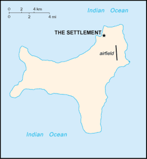
Flying Fish Cove is the capital city and main settlement of Australia's Christmas Island. Although it was originally named after British survey-ship Flying-Fish, many maps simply label it "The Settlement". It was the first British settlement on the island, established in 1888.

A cable railway is a railway that uses a cable, rope or chain to haul trains. It is a specific type of cable transportation.

Pine Creek is a small town in the Katherine region of the Northern Territory, Australia. As at the 2016 Census there were 328 residents of Pine Creek, which is the fourth largest town between Darwin and Alice Springs.

Blaenavon Industrial Landscape, in and around Blaenavon, Torfaen, Wales, was inscribed a World Heritage Site by UNESCO in 2000. The Blaenavon Ironworks, now a museum, was a major centre of iron production using locally mined or quarried iron ore, coal and limestone. Raw materials and products were transported via horse-drawn tramroads, canals and steam railways. The Landscape includes protected or listed monuments of the industrial processes, transport infrastructure, workers' housing and other aspects of early industrialisation in South Wales.

The West Somerset Mineral Railway was a standard gauge line in Somerset, England. Originally expected to be 13 miles 420 yards (21.3 km) long its length as built was 11+1⁄2 miles (18.5 km), with a 310 yards (280 m) branch to Raleigh's Cross Mine. The line's core purpose was to carry iron ore northwards from mines on the Brendon Hills to Watchet harbour on the Bristol Channel. From there the ore was shipped northwards to Newport where it was unloaded onto railway wagons and hauled to ironworks at Ebbw Vale. The line opened as intended in 1861. Passenger services commenced in 1865. The mines' and line's "period of prosperity" ended in 1875 and by 1883 all mining had ceased. The line lingered on for passengers and small goods until 1898, when it closed.

Joadja is a historic town, now in ruins, in the Southern Highlands of New South Wales, Australia, in Wingecarribee Shire. The remnants of the town were added to the New South Wales State Heritage Register on 5 November 1999.
The Rimutaka Incline Railway Heritage Trust is a non-profit, charitable trust in New Zealand that was established in 2003 with the objective of reinstating an operating heritage railway over the Remutaka Ranges using the original route of the Wairarapa Line between Maymorn and Featherston, including the world-famous Rimutaka Incline.

Summit railway station was at the summit of the Wairarapa Line over the Rimutaka Ranges in the Wellington region of New Zealand’s North Island and was where trains were marshalled for a descent down the Rimutaka Incline or for Fell locomotives to be extricated from a train that had ascended the Incline. The station was between Kaitoke and Cross Creek stations on the Wairarapa Line. The station was bypassed when the Rimutaka Tunnel was opened.
The Rosedale Railway was an 19.5-mile (31.4 km) goods-only railway line running from Battersby Junction via Ingleby Incline, across the heights of the North York Moors in North Yorkshire, England to reach iron ore deposits in the remote hills of the Rosedale valley. It opened to traffic as a narrow gauge railway to Ingleby Incline top in 1858, converted to standard gauge and opened to Rosedale West in 1861, and closed completely in 1929. Apart from Ingleby Incline, no major engineering works were constructed, and as such, particularly the east branch, the railway followed the contours of the surrounding hillside. The former trackbeds of the railway are in use by walkers and cyclists.

The following outline is provided as an overview of and topical guide to Christmas Island:

Orange railway station is a heritage-listed former railway bridge and now railway station located on the Main Western line on Peisley Street, Orange in the City of Orange local government area of New South Wales, Australia. It was built from 1877 to 1950. It is also known as Orange Railway Station and yard group. The property was added to the New South Wales State Heritage Register on 2 April 1999.
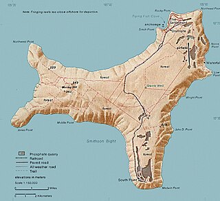
The Christmas Island Phosphate Co.'s Railway was a 19.7 km long industrial railway between Flying Fish Cove and South Point on Christmas Island. The remains of the South Point station are now heritage-listed.

South Point Settlement Remains is a heritage-listed former settlement at South Point on Christmas Island, Australia. It was added to the Australian Commonwealth Heritage List on 22 June 2004.

The Industrial and Administrative Group is a heritage-listed historic precinct on Murray Road overlooking Flying Fish Cove in the Australian territory of Christmas Island. It was added to the Australian Commonwealth Heritage List on 22 June 2004.
Phosphate Hill Historic Area is a heritage-listed historic precinct located one kilometre east of Poon Saan in the Australian territory of Christmas Island. It was added to the Australian Commonwealth Heritage List on 22 June 2004.

The Administrator's House is a heritage-listed former official residence and now museum located 1.5 kilometres (0.93 mi) south-west of Flying Fish Cove in the Australian territory of Christmas Island. It was added to the Australian Commonwealth Heritage List on 22 June 2004. It is also known as Tai Jin House. The house served as the official residence for the Administrator of Christmas Island.

