Drumtroddan standing stones

Last updated

Drumtroddan standing stones
Drumtroddan standing stones - geograph.org.uk - 91414.jpg
The site in 2005 before the second stone fell.
Coordinates 54°46′01″N4°32′38″W / 54.766910°N 4.5437526°W / 54.766910; -4.5437526 Coordinates: 54°46′01″N4°32′38″W / 54.766910°N 4.5437526°W / 54.766910; -4.5437526
Designated31 December 1921
Reference no. SM90102
Dumfries and Galloway UK location map.svg
Red pog.svg
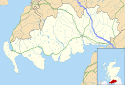
Location of Drumtroddan standing stones in Dumfries and Galloway

The Drumtroddan standing stones (grid reference NX 36449 44300 ) are a small Neolithic or Bronze Age stone alignment in the parish of Mochrum, Wigtownshire, Dumfries and Galloway. [1] The monument comprises three stones, only one of which is now standing, aligned northeast-southwest. [2] [3] The two end stones are 3m in length; the middle stone is roughly 2.7m long. [3] The stones were likely set up in the 3rd or 2nd millennium BCE but sites of this type are difficult to date. [2] Short stone row alignments are considered to be relatively late constructions; however, the height of the stones in this monument may indicate that it dates from an earlier period. [2]

The original purpose of the monument is unclear. It has been suggested that it may have been used in observations of the sun or moon. [2] Monuments of this type are found in concentrations in south-west Ireland, south-west Scotland, and the western seaboards of Scotland. [2] The standing stones are part of larger landscape of prehistoric sites which includes the nearby Drumtroddan cup and ring marked rocks and the Big Balcraig cup and ring marked rocks. [2]

Drumtroddan is a Gaelic name meaning 'ridge of the quarrel' from Gaelic druim 'ridge' and trodan 'quarrel, contention'. [4] [5]
Related Research Articles

Stranraer Town and sea port in Scotland

Stranraer, also known as The Toon, is a town in Dumfries and Galloway, Scotland. It is located in the historical parish of Inch in the historic county of Wigtownshire. It lies on the shores of Loch Ryan, on the northern side of the isthmus joining the Rhins of Galloway to the mainland. Stranraer is Dumfries and Galloway's second-largest town, with a population including the immediate surrounding area of nearly 13,000 inhabitants.

Galloway Region in southwestern Scotland

Galloway is a region in southwestern Scotland comprising the historic counties of Wigtownshire and Kirkcudbrightshire. It is administered as part of the council area of Dumfries and Galloway.

Wigtownshire Historic county in Scotland

Wigtownshire or the County of Wigtown is a historic county, registration county and lieutenancy area in south-west Scotland. It is popularly known as and referred to as The Shire. Until 1975, Wigtownshire was one of the administrative counties used for local government purposes, and is now administered as part of the council area of Dumfries and Galloway. As a lieutenancy area, Wigtownshire has its own Lord Lieutenant, currently John Alexander Ross. In the 19th century, it was also called West Galloway. The county town was historically Wigtown, with the administrative centre moving to Stranraer, the largest town, on the creation of a county council in 1890.

Kilmartin Glen British Neolithic monument site

Kilmartin Glen is an area in Argyll north of Knapdale. It has the most important concentration of Neolithic and Bronze Age remains in mainland Scotland. The glen is located between Oban and Lochgilphead, surrounding the village of Kilmartin. In the village, Kilmartin Museum explains the stories of this ancient landscape and the people who dwelt there. There are more than 800 ancient monuments within a six-mile (ten-kilometre) radius of the village, with 150 monuments being prehistoric. Monuments include standing stones, a henge monument, numerous cists, and a "linear cemetery" comprising five burial cairns. Several of these, as well as many natural rocks, are decorated with cup and ring marks.

Machars

The Machars is a peninsula in the historical county of Wigtownshire in Galloway in the south-west of Scotland. Its name is derived from the Gaelic word Machair meaning low-lying or level land, known as "links" on the east coast of Scotland. Although there are no high peaks in The Machars, it is not flat and would best be described as undulating or rolling. The North Atlantic Drift or Gulf Stream creates a mild climate, and dolphins and basking sharks are frequently seen in the seas.

New Luce is a civil parish in Dumfries and Galloway, south-west Scotland. It lies in the traditional county of Wigtownshire, and is about 10 miles (16 km) in length and 5 miles (8.0 km) in breath, being the upper part of the original Glenluce Parish. New Luce is shown as a civil parish on John Ainslie's county map of 1782.

Clan MacDowall Lowland Scottish clan

Clan MacDowall or MacDouall is a Lowlands Scottish clan.

Glasserton is a civil parish in Dumfries and Galloway, south-west Scotland. It is on the Machars peninsula, in the traditional county of Wigtownshire. The parish is about 8 miles (13 km) in length, varying in breadth from 1 to 3 miles, and contains 13,477 acres (54.54 km2).

Stoneykirk is an area and a village in the heart of the Rhins of Galloway, Wigtownshire, in the administrative council area of Dumfries and Galloway, Scotland nearly ten miles in length and three and a half miles in breadth, bounded on the east by the bay of Luce, and on the west by the Irish Channel, 5 miles (8.0 km) south of Stranraer.

Swainbost Human settlement in Scotland

Swainbost is a village on the Isle of Lewis in the district of Ness, in the Outer Hebrides, Scotland. The name Swainbost meaning Sweins steading is of Viking derivation. The settlement is situated in the parish of Barvas. According to Ronald Black, Swainbost was re-settled during the Highland Clearances in 1842. The island's Anglo-Scottish landlord had expected the crofters evicted from Uig to emigrate and only reluctantly granted them land at Swainbost to avert the threat of violence.

Cargenbridge Human settlement in Scotland

Cargenbridge is a village located in Dumfries and Galloway, United Kingdom southwest of Dumfries. It is in Troqueer parish, in the historic county of Kirkcudbrightshire.

Leswalt is a village and civil parish in Dumfries and Galloway, south-west Scotland. It lies between Portpatrick and Stranraer in the Rhins of Galloway, part of the traditional county of Wigtownshire. The parish covers around 8 square miles (21 km2).

Kirkcolm Human settlement in Scotland

Kirkcolm is a village and civil parish on the northern tip of the Rhinns of Galloway peninsula, south-west Scotland. It is in Dumfries and Galloway, and is part of the former county of Wigtownshire. The parish is bounded on the north and west by the sea, on the east by the bay of Loch Ryan and on the south by Leswalt parish.

Inch, Dumfries and Galloway Human settlement in Scotland

Inch is a civil parish in Dumfries and Galloway, southwest Scotland. It lies on the shore of Loch Ryan, in the traditional county of Wigtownshire.

Old Luce is a civil parish in Dumfries and Galloway, Scotland. It lies in the Machars peninsula, in the traditional county of Wigtownshire. The parish is around 10 miles (16 km) long and 8 miles (13 km) broad, and contains 40,350 acres (16,330 ha).

Wrens Egg

The Wren's Egg is the name given to a set of late Neolithic or Bronze Age stone monuments in the parish of Glasserton, Wigtownshire, Dumfries and Galloway. The site comprises two pairs of standing stones to the north and south of a large glacial erratic, the Wren's Egg itself. It was one of the first monuments taken into state care after the Ancient Monuments Act passed in 1882.

Droughdool Mote

Droughdool Mote is a Neolithic round mound in the parish of Old Luce, Wigtownshire, Dumfries and Galloway. The mound is oval in plan, measuring 60m by 50m at its base and rises to 10m in height. It is located 400m south of the late neolithic palisaded enclosure at Dunragit. It has been suggested that the mound may have been used as a viewing platform for activities at Dunragit complex of monuments. The most well known parallel the site has is Silbury Hill in Wiltshire, but is closer in size to the less well known sites at Conquer Barrow, Willy Howe and Wold Newton. The mound was originally built with stepped sides on top of a sand dune. Excavation between 1999-2002 revealed a round cairn at the top of the mound, similar to the nearby Mid Gleniron A.

Tomnaverie stone circle Recumbent stone circle in Aberdeenshire

Tomnaverie stone circle is a recumbent stone circle set on the top of a small hill in lowland northeast Scotland. Construction started from about 2500 BC, in the Bronze Age, to produce a monument of thirteen granite stones including a massive 6.5-ton recumbent stone lying on its side along the southwest of the circle's perimeter. Within the 17-metre (56 ft) circle are kerb stones encircling a low 15-metre (49 ft) ring cairn but the cairn itself no longer exists.

Mid Gleniron

Mid Gleniron is a prehistoric site in Dumfries and Galloway used in the Neolithic and Bronze Age. The site is a scheduled ancient monument that comprises a group of six burial cairns. Two of the cairns, Mid Gleniron I and Mid Gleniron II are chambered cairns of the Clyde tradition. These are of historic importance because of their multi-stage construction which provides evidence for the development of Clyde cairns at the beginning of the Neolithic period.

High Banks cup and ring markings

The High Banks cup and ring markings are a series of Neolithic or Bronze Age carvings on an outcrop of rock near High Banks farm, 3 km SE of Kirkcudbright, Dumfries and Galloway. They are one of the best collections of cup and ring markings in Galloway.

References

  1. "Drumtroddan | Canmore". canmore.org.uk. Archived from the original on 11 November 2019. Retrieved 11 November 2019.
  2. 1 2 3 4 5 6 "Drumtroddan Standing Stones Statement of Significance | HES | History". www.historicenvironment.scot. Archived from the original on 7 May 2019. Retrieved 11 November 2019.
  3. 1 2 "Drumtroddan,three standing stones SE of High Park Plantation (SM90102)". portal.historicenvironment.scot. Archived from the original on 14 November 2018. Retrieved 11 November 2019.
  4. MacQueen, John (2008). Place-names of the Wigtownshire Moors and Machars. Stranraer: Stranraer and District Local History Trust. p. 109. ISBN   978 0 9542966 9 8.
  5. Maxwell, Herbert (1930). The Place Names of Galloway: Their Origin & Meaning Considered. Wigtown: G. C. Book Publishers Ltd. pp. 126–127.