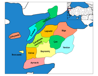
Bayramiç is a town and district of Çanakkale Province in the Marmara region of Turkey. According to the 2000 census, population of the district is 32,314 of which 13,420 live in the town of Bayramiç. The district covers an area of 1,284 km2 (496 sq mi), and the town lies at an elevation of 107 m (351 ft).

Stobno is a village in the administrative district of Gmina Tuchola, within Tuchola County, Kuyavian-Pomeranian Voivodeship, in north-central Poland. It lies approximately 6 kilometres (4 mi) north-west of Tuchola and 61 km (38 mi) north of Bydgoszcz. It is located to the southwest of Lake Stobno.
Grzyby-Orzepy is a village in the administrative district of Gmina Siemiatycze, within Siemiatycze County, Podlaskie Voivodeship, in north-eastern Poland.

Əncəqov is a village in the Lerik Rayon of Azerbaijan. The village forms part of the municipality of Bobla.
Wierzchy is a village in the administrative district of Gmina Zadzim, within Poddębice County, Łódź Voivodeship, in central Poland. It lies approximately 5 kilometres (3 mi) north-east of Zadzim, 11 km (7 mi) south-west of Poddębice, and 40 km (25 mi) west of the regional capital Łódź.
Wola Kurowska is a village in the administrative district of Gmina Chełmiec, within Nowy Sącz County, Lesser Poland Voivodeship, in southern Poland. It lies approximately 7 kilometres (4 mi) north of Chełmiec, 8 km (5 mi) north of Nowy Sącz, and 68 km (42 mi) south-east of the regional capital Kraków.
Józefków is a village in the administrative district of Gmina Zawichost, within Sandomierz County, Świętokrzyskie Voivodeship, in south-central Poland. It lies approximately 10 kilometres (6 mi) west of Zawichost, 15 km (9 mi) north of Sandomierz, and 79 km (49 mi) east of the regional capital Kielce.
Osiek is a village in the administrative district of Gmina Zawidz, within Sierpc County, Masovian Voivodeship, in east-central Poland.
Ludwikowo is a village in the administrative district of Gmina Mosina, within Poznań County, Greater Poland Voivodeship, in west-central Poland.
Botany Bay, Monmouthshire is an area in the Wye Valley in Wales, above the village of Tintern. It is the location of a Gwent Scouts camp site covering 27 acres (11 ha).
Dąbrowa is a village in Opole County, Opole Voivodeship, in south-western Poland. It is the seat of the gmina called Gmina Dąbrowa. It lies approximately 14 km (9 mi) west of the regional capital Opole.
Czachówek is a village in the administrative district of Gmina Gardeja, within Kwidzyn County, Pomeranian Voivodeship, in northern Poland. It lies approximately 9 kilometres (6 mi) north of Gardeja, 7 km (4 mi) south-east of Kwidzyn, and 80 km (50 mi) south of the regional capital Gdańsk.
Karwica is a village in the administrative district of Gmina Cewice, within Lębork County, Pomeranian Voivodeship, in northern Poland. It lies approximately 4 kilometres (2 mi) south-west of Cewice, 15 km (9 mi) south of Lębork, and 62 km (39 mi) west of the regional capital Gdańsk.
Łebunia is a village in the administrative district of Gmina Cewice, within Lębork County, Pomeranian Voivodeship, in northern Poland. It lies approximately 6 kilometres (4 mi) east of Cewice, 12 km (7 mi) south of Lębork, and 54 km (34 mi) west of the regional capital Gdańsk.
Wielisławice is a village in the administrative district of Gmina Szczecinek, within Szczecinek County, West Pomeranian Voivodeship, in north-western Poland. It lies approximately 9 kilometres (6 mi) east of Szczecinek and 151 km (94 mi) east of the regional capital Szczecin.
Kunowo is a settlement in the administrative district of Gmina Świdwin, within Świdwin County, West Pomeranian Voivodeship, in north-western Poland. It lies approximately 6 kilometres (4 mi) north-west of Świdwin and 86 km (53 mi) north-east of the regional capital Szczecin.

Gornje Konjuvce is a village in the municipality of Bojnik, Serbia. According to the 2002 census, the village has a population of 172 people.
Võntküla is a village in Lääne-Nigula Parish, Lääne County, in western Estonia.

Dorsey is an unincorporated community in Holt County, Nebraska, in the United States. with a population of roughly 30. And is around 9 miles away from the smallest village in the USA monowi Nebraska which has a booming population of 1.


