Coal is a combustible black or brownish-black sedimentary rock, formed as rock strata called coal seams. Coal is mostly carbon with variable amounts of other elements, chiefly hydrogen, sulfur, oxygen, and nitrogen. Coal is formed when dead plant matter decays into peat and is converted into coal by the heat and pressure of deep burial over millions of years. Vast deposits of coal originate in former wetlands—called coal forests—that covered much of the Earth's tropical land areas during the late Carboniferous (Pennsylvanian) and Permian times. However, many significant coal deposits are younger than this and originate from the Mesozoic and Cenozoic eras.

Bituminous coal, or black coal, is a type of coal containing a tar-like substance called bitumen or asphalt. Its coloration can be black or sometimes dark brown; often there are well-defined bands of bright and dull material within the seams. It is typically hard but friable. Its quality is ranked higher than lignite and sub-bituminous coal, but lesser than anthracite. It is the most abundant rank of coal, with deposits found around the world, often in rocks of Carboniferous age. Bituminous coal is formed from sub-bituminous coal that is buried deeply enough to be heated to 85 °C (185 °F) or higher.

Anthracite, also known as hard coal, and black coal, is a hard, compact variety of coal that has a submetallic luster. It has the highest carbon content, the fewest impurities, and the highest energy density of all types of coal and is the highest ranking of coals.
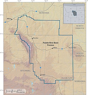
The Powder River Basin is a geologic structural basin in southeast Montana and northeast Wyoming, about 120 miles (190 km) east to west and 200 miles (320 km) north to south, known for its extensive coal reserves. The former hunting grounds of the Oglala Lakota, the area is very sparsely populated and is known for its rolling grasslands and semiarid climate.
Sub-bituminous coal is a lower grade of coal that contains 35–45% carbon. The properties of this type are between those of lignite, the lowest grade of coal, and those of bituminous coal, the second-highest grade of coal. Sub-bituminous coal is primarily used as a fuel for steam-electric power generation.

Cerrejón is a large open-pit coal mine in Northern Colombia owned by Glencore. At Cerrejón, low-ash, low-sulphur bituminous coal from the Cerrejón Formation is excavated. At over 690 square kilometres (270 sq mi) the mine is one of the largest of its type, the largest in Latin America and the tenth biggest in the world. Cerrejón is divided into three sections, North Zone, Central Zone and South Zone. Total proven reserves are estimated at 503 megatonnes. In 2016, the mine produced 32,683,315 tonnes.
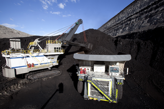
Coal mining regions are significant resource extraction industries in many parts of the world. They provide a large amount of the fossil fuel energy in the world economy.
According to the United States Energy Information Administration (EIA), Pakistan may have over 9 billion barrels (1.4×10⁹ cubic metres) of petroleum oil and 105 trillion cubic feet (3.0 trillion cubic metres) in natural gas (including shale gas) reserves.
Arch Resources, previously known as Arch Coal, is an American coal mining and processing company. The company mines, processes, and markets bituminous and sub-bituminous coal with low sulfur content in the United States. Arch Resources is the second-largest supplier of coal in the United States, behind Peabody Energy. As of 2011 the company supplied 15% of the domestic market. Demand comes mainly from generators of electricity.
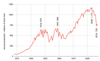
Coal mining in the United States is an industry in transition. Production in 2019 was down 40% from the peak production of 1,171.8 million short tons in 2008. Employment of 43,000 coal miners is down from a peak of 883,000 in 1923. Generation of electricity is the largest user of coal, being used to produce 50% of electric power in 2005 and 27% in 2018. The U.S. is a net exporter of coal. U.S. coal exports, for which Europe is the largest customer, peaked in 2012. In 2015, the U.S. exported 7.0 percent of mined coal.
Refined coal is the product of the application of a coal-upgrading technology that removes moisture and certain pollutants from lower-rank coals such as sub-bituminous and lignite (brown) coals and raising their calorific values. Coal refining or upgrading technologies are typically pre-combustion treatments and/or processes that alter the characteristics of a coal before it is burned. The goals of pre-combustion coal-upgrading technologies are to increase efficiency and reduce emissions when coal is burned. Depending on the situation, pre-combustion technology can be used in place of or as a supplement to post-combustion technologies to control emissions from coal-fueled boilers. A primary benefit of refined coal is the capacity to reduce the net volume of carbon emissions that is currently emitted from power generators and would reduce the amount of emissions that is proposed to be managed via emerging carbon sequestration methodologies. Refined coal technologies have primarily been developed in the United States, several similar technologies have been researched, developed and tested in Victoria, Australia, including the Densified coal technology developed to alter the chemical bonds of brown coal to create a product that is cleaner, stable, exportable and of sufficiently high calorific value to be a black coal equivalent.
The history of coal mining in the United States goes back to the 1300s, when the Hopi Indians used coal. The first commercial use came in 1701, within the Manakin-Sabot area of Richmond, Virginia. Coal was the dominant power source in the United States in the late 1800s and early 1900s, and although in rapid decline it remains a significant source of energy in 2019.
The Belle Ayr mine is a coal mine located 18 miles southeast of Gillette, Wyoming in the United States in the coal-rich Powder River Basin. The mine is an open pit, "truck and shovel", mine producing a low-sulfur, sub-bituminous coal from the Wyodak-Anderson seam that is used for domestic energy generation. Coal produced by the mine is shipped to its customers via railroad. The mine is currently owned and operated by Blackjewel LLC after being acquired from Contura energy in 2017.
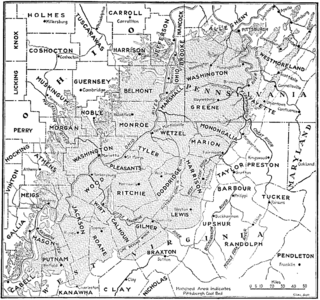
The Pittsburgh Coal Seam is the thickest and most extensive coal bed in the Appalachian Basin; hence, it is the most economically important coal bed in the eastern United States. The Upper Pennsylvanian Pittsburgh coal bed of the Monongahela Group is extensive and continuous, extending over 11,000 mi2 through 53 counties. It extends from Allegany County, Maryland to Belmont County, Ohio and from Allegheny County, Pennsylvania southwest to Putnam County, West Virginia.
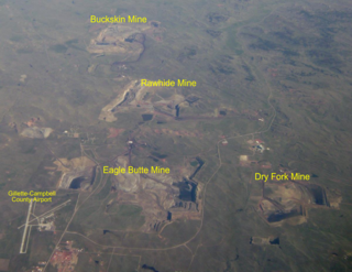
The Eagle Butte mine is a coal mine located 7 miles (11 km) north of Gillette, Wyoming in the United States in the coal-rich Powder River Basin. The mine is an open pit, "truck and shovel", mine producing a low-sulfur, sub-bituminous coal from the Roland and Smith seams that is used for domestic energy generation. Coal produced by the mine is shipped to its customers via railroad. The mine is currently owned and operated by Blackjewel LLC after being acquired from Contura energy in 2017.
The Rawhide Mine is a coal mine located 10 miles (16.1 km) north of Gillette, Wyoming in the United States in the coal-rich Powder River Basin. The mine is an open pit mine that utilizes a combination of cast blast/dozer push and truck/shovel mining methods to strip an average of 165 feet (50.3m) of overburden off of approximately 105 (32.0m) feet of coal. Rawhide produces a low-sulfur, sub-bituminous coal from the Roland and Smith seams. This coal is used for domestic energy generation and shipped to customers via railroad. The mine is currently owned and operated by Peabody Energy.

The Wyodak mine is a coal mine in Wyodak, Wyoming, United States, located about 6 miles (9.7 km) east of Gillette in the coal-rich Powder River Basin.
Coal was discovered in Kentucky in 1750. Since the first commercial coal mine opened in 1820 coal has gained both economic importance and controversy regarding its environmental consequences. As of 2010 there were 442 operating coal mines in the state, and as of 2017 there were fewer than 4,000 underground coalminers.
Coal mining in Wyoming has long been a significant part of the state's economy. Wyoming has been the largest producer of coal in the United States since 1986, and in 2018, coal mines employed approximately 1% of the state’s population. In 2013, there were 17 active coal mines in Wyoming, which produced 388 million short tons, 39 percent of all the coal mined in the US, and more than three times the production of second-place West Virginia. Market forces, including the low price of natural gas from the fracking boom—coal's main competition—contributed to the steep drop in coal production in the 2000s as electricity generation switched from coal to gas.

The North Antelope Rochelle Mine is the largest coal mine in the world. Located in Campbell County, Wyoming, about 65 miles south of Gillette, it produced 85.3 million tons of coal in 2019.