
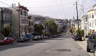
The Duboce Triangle neighborhood is located near the center of San Francisco, California just below the hilly slopes of Buena Vista Park between the neighborhoods of the Castro/Eureka Valley, the Mission District, and the Lower Haight. The area is sometimes known as Mint Hill, after the United States Mint, nearby on a steep rocky cliff overlooking the intersection of Market and Duboce streets. The neighborhood is bounded bordered by Market St., Castro St., and Duboce Avenue.

The N Judah is a Muni Metro light rail line in San Francisco, California, so named as it runs along Judah Street for much of its length, named after railroad engineer Theodore Judah. It links downtown San Francisco to the Cole Valley and Sunset neighborhoods. It is the busiest line in the Muni Metro system, serving an average of 41,439 weekday passengers in 2013. It was one of San Francisco's streetcar lines, beginning operation in 1928, and was partially converted to modern light-rail operation with the opening of the Muni Metro system in 1980. While many streetcar lines were converted to bus lines after World War II, the N Judah remained a streetcar line due to its use of the Sunset Tunnel.

Church Street is a Muni Metro light rail station at the six-way intersection of Market Street, Church Street and 14th Street in the Duboce Triangle neighborhood of San Francisco, California. Service at the station began in June 1980.

The Sunset Tunnel, originally known as the Duboce Tunnel, is a 4,232 ft (1,290 m)-long light rail/streetcar tunnel in San Francisco, California. The tunnel runs under the steep hill adjacent to Buena Vista Park and is used exclusively by the N Judah Muni Metro line.

Hayes Valley is a neighborhood in the Western Addition district of San Francisco, California. It is located between the historical districts of Alamo Square and the Civic Center. Victorian, Queen Anne, and Edwardian townhouses are mixed with high-end boutiques, restaurants, and public housing complexes.

The Lower Haight is a neighborhood, sometimes referred to as Haight-Fillmore, in San Francisco, California.
Eureka Valley is a neighborhood in San Francisco, primarily a quiet residential neighborhood but boasting one of the most visited sub-neighborhoods in the city, The Castro.

The 2006 San Francisco Board of Supervisors elections occurred on November 7, 2006. Five of the eleven seats were contested in this election. Four of the five incumbents ran for reelection, while one sought another elected office.

The Wiggle is a one-mile, zig-zagging bicycle route from Market Street to Golden Gate Park in San Francisco, California, that minimizes hilly inclines for bicycle riders. Rising 120 feet (37 m), The Wiggle inclines average 3% and never exceed 6%. The path generally follows the historical route of the long since paved-over Sans Souci Valley watercourse, winding through the Lower Haight neighborhood toward the Panhandle section of Golden Gate Park.

Taylor & Ng, founded in 1965, is a retailer of Asian-inspired cooking supplies and kitchen furnishings made popular in the 1970s and 1980s. Currently selling products online.
The 2002 San Francisco Board of Supervisors elections occurred on November 5, 2002, with runoff elections held on December 10, 2002. Five of the eleven seats were contested in this election. Three incumbents ran for reelection, while two sought another office.

Duboce and Church is a light rail stop on the Muni Metro J Church and N Judah lines, located in the Duboce Triangle neighborhood of San Francisco, California. Just east of the station, the two lines enter the Market Street Subway. The station originally opened with the 22 Fillmore line in 1895.
The 2010 San Francisco Board of Supervisors elections were held on November 2, 2010. Five of the eleven seats of the San Francisco Board of Supervisors were contested in this election. Four incumbents were termed out of office, while one ran for reelection.

The Pink Triangle Park is a triangular shaped mini-park located in the Castro District of San Francisco, California. The park is less than 4,000 square feet and faces Market Street with 17th Street to its back. The park sits directly above the Castro Street Station of Muni Metro, across from Harvey Milk Plaza. It is the first permanent, free-standing memorial in America dedicated to the thousands of persecuted homosexuals in Nazi Germany during the Holocaust of World War II.
St. Francis Lutheran Church is located at 152 Church Street, between Market Street and Duboce Street in San Francisco, California. The church building has stained glass windows and Memorial Terrace outside.
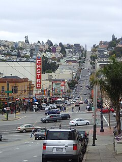
The Castro District, commonly referenced as The Castro, is a neighborhood in Eureka Valley in San Francisco. The Castro was one of the first gay neighborhoods in the United States. Having transformed from a working-class neighborhood through the 1960s and 1970s, the Castro remains one of the most prominent symbols of lesbian, gay, bisexual, and transgender (LGBT) activism and events in the world.
Victor Donglain Duboce served as a lieutenant colonel of the First California Volunteer Infantry regiment in the Philippines during the Spanish–American War. He remained in the Philippines for the opening months of the Philippine–American War, during which he was promoted to colonel. Upon his return to San Francisco he was hailed as a war hero and elected to the Board of Supervisors. He is the namesake of Duboce Street, Duboce Park, and the surrounding neighborhood in San Francisco.
The 2014 San Francisco Board of Supervisors elections occurred on November 4, 2014. Five of the eleven seats of the San Francisco Board of Supervisors were contested in this election. Incumbents in all five districts successfully ran for re-election.


