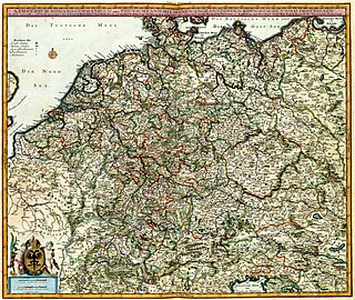
The Westphalian duchy formed the largest part of the Cologne electorate. Apart from the fertile Hellweg Börde north of the Haar hill range, part of the Westphalian Lowland, the ducal lands primarily comprised mountainous and densely forested areas, with some significant metal deposits and brine springs. The Hellweg section connecting the towns of Werl, Erwitte and Geseke was part of an important trade route from Aachen to Goslar.
History
Formerly part of the Saxon stem duchy along with Angria and Eastphalia, the Westphalian lands were Christianized by the Cologne archbishops at the behest of the Frankish ruler Charlemagne upon his conquests in the Saxon Wars. First parishes were established east of the Rhenish estates around Soest, where the archbishops extended their episcopal territory. Numerous monastery foundations, like Grafschaft Abbey in 1072 by Anno II of Cologne, stabilized the ecclesiastical rule.
Creation of the duchy (1102–1180)
In the fierce Investiture Controversy, Archbishop Frederick I of Cologne in 1102 had occupied and seized half of the territory held by the Westphalian counts of Arnsberg, supporters of Emperor Henry IV. The other counties of the region could not resist the encroachment of the mighty Archbishopric, and soon after the counties of Werl, Rüthen and Volmarstein (near Wetter) followed. The former counts of Werl created a new county known as Werl-Arnsberg, and managed to keep their smaller and smaller territory independent of the Archbishops until they finally sold in 1368. After the rebellious Saxon duke Henry the Lion was defeated in 1180, Emperor Frederick Barbarossa presented the Archbishop of Cologne, Philip of Heinsberg with these territories and the southwest of the former Duchy of Saxony as the 'Duchy of Westphalia'.
Expansion (1180–1445)
Engelbert of Berg, archbishop of Cologne from 1220, began a campaign to force the nobility in Westphalia into submission and to extract from them the stewardship of the various scattered church lands. Engelbert managed to connect the lands of the duchy by annexing the territory from Hellweg to Diemel, and secured the south of the Sauerland at Attendorn in 1222. Further controversy of its expansion eventually leads to Engelbert's death at the hands of Frederick I of Isenberg in 1225. In 1260 by an agreement with the Dukes of Brunswick the Weser River became the official border of their spheres of influence. In 1277 the archbishops managed to defeat a large confederation of Westphalian and Lower Rhenish opponents, but further action in 1288 forced the archbishops to abandon intentions on much of the greater territory of Westphalia. The purchase and annexation of Werl-Arnsberg in 1368 united the territories of the north and south of the Sauerland.
Archbishop Frederick von Saarwerden began a hopeless campaign to maintain Colognian rights in Marck, and in 1392 was forced to abandon them. His successor, Dietrich II of Moers witnessed the last attempts by Cologne to gain rulership in Westphalia by attempting to break the powerful positions of Cleves and Marck. The financial burden placed upon the knights and cities of the Duchy of Westphalia led them into union in 1437. Cologne made peace with Cleves in 1441: this led Soest, the richest town of Westphalia, to refuse recognising Colognian supremacy in 1444 in the Soest Feud, that lasted until 1449. Soest had become a part of the Duchy of Cleves. Thereafter the town of Arnsberg became the administrative capital of Westphalia. Economically the loss of Soest had weakened the duchy. Especially as the surroundings of the town were very fertile and the grain was needed for the mountainous regions in the South. Peace with Marck was made in 1445 which witnessed territorial concessions from both sides.
Westphalia until the end of the Empire (1445–1806)
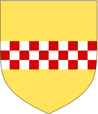
Arms of Westphalia (adopted in 1532)
After the Soest Feud, the city of Soest remained part of the Duchy of Cleves. Starting from 1463, the league of knights and cities in Westphalia began a long and bitter struggle against the archbishops. During the reign of Archbishop Herman V of Wied (1515–1546), the Reformation arrived in Westphalia. Eventually the Reformation was suppressed, but during the reign of Archbishop Gebhard Truchsess von Waldburg (1577–1583) the Reformation returned and he was forced to attend to Westphalia in 1582 where several knights and cities had adopted the new doctrine. The newly elected Archbishop Ernest of Bavaria (1583–1612) and his brother Ferdinand of Bavaria managed to regain the duchy for the archbishopric at the beginning of the Cologne War in 1583, and Protestantism survived only on the border region of Waldeck and Hesse. The Duchy of Westphalia was again confirmed as integral territory of the archbishopric in 1590.
Like most other territories of Germany, Westphalia suffered during the Thirty Years' War. In 1794 the archbishops relocated to Westphalia after the French had annexed the territories west of the Rhine River. In the secularisation of 1803 the Duchy of Westphalia became part of Hesse-Darmstadt.
After the Empire (1806–1815)
In 1807 the Kingdom of Westphalia was created although it did not include the Duchy and had its capital in Hesse at Kassel. In 1815 the Congress of Vienna awarded the Duchy of Westphalia to Prussia in exchange for important lands west of the Rhine, and the Duchy was incorporated into the Province of Westphalia the same year.
Sources
This article incorporates text from a publication now in the public domain:Herbermann, Charles, ed. (1913). "Westphalia". Catholic Encyclopedia. New York: Robert Appleton Company.
Westphalia is a region of northwestern Germany and one of the three historic parts of the state of North Rhine-Westphalia. It has an area of 20,210 square kilometres (7,800 sq mi) and 7.9 million inhabitants.
The Rhineland is a loosely defined area of Western Germany along the Rhine, chiefly its middle section.
This article is about the history of Hesse. Hesse is a state in Germany.
Altena is a town in the district of Märkischer Kreis, North Rhine-Westphalia, Germany. The town's castle is the origin for the later Dukes of Berg. Altena is situated on the Lenne river valley, in the northern stretches of the Sauerland.
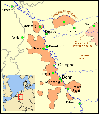
Soest is a city in North Rhine-Westphalia, Germany. It is the capital of the Soest district.
Soest is a Kreis (district) in the middle of North Rhine-Westphalia, Germany. Neighbouring districts are Warendorf, Gütersloh, Paderborn, Hochsauerland, Märkischer Kreis, Unna and the independent town of Hamm.
The County of Mark was a county and state of the Holy Roman Empire in the Lower Rhenish–Westphalian Circle. It lay on both sides of the Ruhr River along the Volme and Lenne rivers.
The Electorate of Cologne, sometimes referred to as Electoral Cologne, was an ecclesiastical principality of the Holy Roman Empire that existed from the 10th to the early 19th century. It consisted of the Hochstift — the temporal possessions — of the archbishop of Cologne, and was ruled by him in his capacity as prince-elector. There were only two other ecclesiastical prince-electors in the Empire: the Electorate of Mainz and the Electorate of Trier. The archbishop-elector of Cologne was also arch-chancellor of Italy and, as such, ranked second among all ecclesiastical and secular princes of the Empire, after the archbishop-elector of Mainz, and before that of Trier.
The Duchy of Cleves was a State of the Holy Roman Empire which emerged from the medieval Hettergau. It was situated in the northern Rhineland on both sides of the Lower Rhine, around its capital Cleves and the towns of Wesel, Kalkar, Xanten, Emmerich, Rees and Duisburg bordering the lands of the Prince-Bishopric of Münster in the east and the Duchy of Brabant in the west. Its history is closely related to that of its southern neighbours: the Duchies of Jülich and Berg, as well as Guelders and the Westphalian county of Mark. The Duchy was archaically known as Cleveland in English.
Nassau-Siegen was a principality within the Holy Roman Empire that existed between 1303 and 1328, and again from 1606 to 1743. From 1626 to 1734, it was subdivided into Catholic and Protestant parts. Its capital was the city of Siegen, founded in 1224 and initially a condominium jointly owned by the archbishopric of Cologne and Nassau. It was located some 50 km east of Cologne, and it contained the modern localities of Freudenberg, Hilchenbach, Kreuztal, Siegen, and Wilnsdorf.
Vest Recklinghausen was an ecclesiastical territory in the Holy Roman Empire, located in the center of today's North Rhine-Westphalia. The rivers Emscher and Lippe formed the border with the County of Mark and Essen Abbey in the south, and to the Bishopric of Münster in the north. In the east, a fortification secured the border with Dortmund and in the west it was bordered by the Duchy of Cleves.
The House of La Marck was a noble family, which from about 1200 appeared as the counts of Mark.
The Westphalian Lowland, also known as the Westphalian Basin is a flat landscape that mainly lies within the German region of Westphalia, although small areas also fall within North Rhine and in Lower Saxony. Together with the neighbouring Lower Rhine Plain to the west, it represents the second most southerly region of the North German Plain, after the Cologne Bight. It is variously known in German as the Westfälische Bucht, the Münsterländer or Westfälische Tieflands- or Flachlandsbucht.
The Battle of Werl occurred between 3–8 March 1586, during a month-long campaign in the Duchy of Westphalia by mercenaries fighting for the Protestant (Calvinist) Archbishop-Prince Elector of Cologne, Gebhard Truchsess von Waldburg.
North Rhine-Westphalia was established by the British military administration's "Operation Marriage" on 23 August 1946 by merging the Rhine Province with the Province of Westphalia. On 21 January 1947, the former Free State of Lippe was merged with North Rhine-Westphalia.
The Cologne Diocesan Feud, also called the Neuss War or Burgundian War, was a conflict, which began in 1473, between the Archbishop of Cologne, Ruprecht of the Palatinate and the Landstände of his archbishopric. As a result of the involvement of Charles the Bold of Burgundy and, eventually, the Holy Roman Empire the matter at times assumed a European dimension. It finally ended when Ruprecht died in 1480.
Fürstenberg Castle, also called the Electoral Cologne State Castle, is a ruined castle near the former site of the village Höingen, in the municipality of Ense, Soest in the German state of North Rhine-Westphalia. Built on a high point above the Ruhr as a castle for the Archbishop of Cologne, who was among the prince electors of the Holy Roman Empire, the site was called the Prince's Hill (Fürstenberg), lending its name to the House of Fürstenberg (Westphalia) that started with the Imperial Knight Hermann, the Lehnsmann who held the castle for the prince when it was first built, c. 1295.
The German Emperors after 1873 had a variety of titles and coats of arms, which in various compositions became the officially used titles and coats of arms. The title and coat of arms were last fixed in 1873, but the titles did not necessarily mean that the area was really dominated, and sometimes even several princes bore the same title.
Frederick von Saarwerden was archbishop-elector of Cologne as Frederick III from 1370 to 1414. Through the promotion of his great-uncle, Archbishop Kuno II of Falkenstein of Trier, Frederick von Saarwerden was elected archbishop of Cologne at the age of 20, which the Pope in Avignon also confirmed two years later after some misgivings. Frederick found the archbishopric completely plundered by his two predecessors of the County of Mark, Adolf and Engelbert, and had himself promised high payments to the Curia on the occasion of his election. Nevertheless, with the help of his very rich great-uncle Kuno, he succeeded in paying off the debts of the archbishopric within a few years.
This page is based on this Wikipedia article Text is available under the CC BY-SA 4.0 license; additional terms may apply. Images, videos and audio are available under their respective licenses.