
Lake Michigan is one of the five Great Lakes of North America. It is the second-largest of the Great Lakes by volume and the third-largest by surface area, after Lake Superior and Lake Huron. To the east, its basin is conjoined with that of Lake Huron through the 3+1⁄2-mile (5.6-kilometer) wide, 295-foot deep Straits of Mackinac, giving it the same surface elevation as its easterly counterpart; geologically, the two bodies are a single lake that is, by area, the largest freshwater lake in the world.

Lake Huron is one of the five Great Lakes of North America. It is shared on the north and east by the Canadian province of Ontario and on the south and west by the U.S. state of Michigan. The name of the lake is derived from early French explorers who named it for the indigenous people they knew as Huron (Wyandot) inhabiting the region. Hydrologically, Lake Huron comprises the eastern portion of Lake Michigan–Huron, having the same surface elevation as Lake Michigan, to which it is connected by the 5-mile-wide (8.0 km), 20-fathom-deep Straits of Mackinac. Combined, Lake Michigan–Huron is the largest freshwater lake by area in the world. The Huronian glaciation was named from evidence collected from Lake Huron region. The northern parts of the lake include the North Channel and Georgian Bay. Saginaw Bay is located in the southwest corner of the lake. The main inlet is the St. Marys River, and the main outlet is through the St. Clair River to Lake Erie. Lake Huron has a fairly large drainage basin covering parts of Michigan and Ontario. Water flows through Lake Huron faster than the other Great Lakes with a retention time of only 22 years.

Chippewa County is a county in the eastern Upper Peninsula of the U.S. state of Michigan. As of the 2020 census, the population was 36,785. The county seat is Sault Ste. Marie. The county is named for the Ojibwe (Chippewa) people, and was set off and organized in 1826. Chippewa County comprises the Sault Ste. Marie, MI micropolitan statistical area.
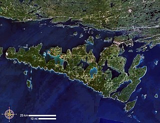
Manitoulin Island is an island in Lake Huron, located within the borders of the Canadian province of Ontario, in the bioregion known as Laurentia. With an area of 2,766 km2 (1,068 sq mi), it is the largest lake island in the world, large enough that it has over 100 lakes itself. In addition to the historic Anishinaabe and European settlement of the island, archaeological discoveries at Sheguiandah have demonstrated Paleo-Indian and Archaic cultures dating from 10,000 BC to 2,000 BC.

Georgian Bay is a large bay of Lake Huron, in the Laurentia bioregion. It is located entirely within the borders of Ontario, Canada. The main body of the bay lies east of the Bruce Peninsula and Manitoulin Island. To its northwest is the North Channel.

Northeastern Manitoulin and the Islands is a municipality with town status in Manitoulin District in Northeastern Ontario, Canada, approximately 30 kilometres (19 mi) south of Espanola. Its main town is Little Current, located on the northeast side of Manitoulin Island. However, its territory also includes most of the small islands surrounding Manitoulin, even those at the far western end of Manitoulin.

Manitoulin District is a district in Northeastern Ontario within the Canadian province of Ontario. It was created in 1888 from part of the Algoma District. The district seat is in Gore Bay.
The Copeland Islands is a group of three islands in the north Irish Sea, north of Donaghadee, County Down, Northern Ireland, consisting of Lighthouse Island, Copeland Island and Mew Island. They lie within the civil parish of Bangor.

The Bruce Peninsula is a peninsula in Ontario, Canada, that divides Georgian Bay of Lake Huron from the lake's main basin. The peninsula extends roughly northwestwards from the rest of Southwestern Ontario, pointing towards Manitoulin Island, with which it forms the widest strait joining Georgian Bay to the rest of Lake Huron. The Bruce Peninsula contains part of the geological formation known as the Niagara Escarpment. The entire peninsula and nearby communities to the south along Lake Huron are located within Bruce County, Ontario.
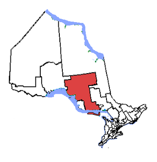
Algoma—Manitoulin—Kapuskasing is a federal electoral district in Ontario, Canada, that has been represented in the House of Commons of Canada since 2004. The area was represented by the riding of Algoma from 1867 to 1904 and from 1968 to 1996 and then by Algoma—Manitoulin from 1996 to 2004.

The current Bodie Island Lighthouse is the third that has stood in this vicinity of Bodie Island on the Outer Banks in North Carolina and was built in 1872. It stands 156 feet (48 m) tall and is located on the Roanoke Sound side of a portion of a peninsula that is the first part of the Cape Hatteras National Seashore. The lighthouse is just south of Nags Head, a few miles before Oregon Inlet. It was renovated from August 2009 to March 2013, and was made climbable by the public. There are 214 steps that spiral to the top. The 170-foot structure is one of only a dozen remaining tall, brick tower lighthouses in the United States — and one of the few with an original first-order Fresnel lens to cast its light.

Great Duck Island is a small island in the Gulf of Maine, 11 miles (18 km) south of the entrance to Frenchman Bay, not far from Acadia National Park. Along with nearby Little Duck Island and 11 others, it is part of the town of Frenchboro.

The Wiikwemkoong First Nation is a First Nation on Manitoulin Island in Northern Ontario. The Wiikwemkoong Unceded Territory is the First Nation reserve in the northeast of Manitoulin Island in Manitoulin District, Ontario, Canada. Wiikwemkoong is an unceded Indigenous reserve in Canada, which means that it has not "relinquished title to its land to the government by treaty or otherwise."
Assateague Light is the 142-foot-tall (43 m) lighthouse located on the southern end of Assateague Island off the coast of the Virginia Eastern Shore, United States. The lighthouse is located within the Chincoteague National Wildlife Refuge and can be accessed by road from Chincoteague Island over the Assateague Channel. It is owned by the U.S. Fish and Wildlife Service and operated by the U.S. Coast Guard and is still used as an active aid in navigation. The keeper's quarters are used as seasonal housing for refuge temporary employees, volunteers, and interns. Constructed in 1867 to replace a shorter lighthouse 45-foot-tall (14 m) built in 1833, the lighthouse is conical in shape and is painted in alternating bands of red and white.

Cockburn Island is an island and township municipality in the Canadian province of Ontario, located in the Manitoulin District. It is separated from the westernmost point of Manitoulin Island by the Mississagi Strait, and from Michigan's Drummond Island by the False Detour Channel. The island is incorporated as and coterminous with the municipal Township of Cockburn Island.

Great Duck Island Light is a lighthouse on Great Duck Island in the town of Frenchboro, Maine, USA. Established in 1890, the light marks the approach to Blue Hill Bay and the southern approaches to Mount Desert Island on the central coast of Maine. The light was listed on the National Register of Historic Places as Great Duck Island Light Station on March 14, 1988. The light is an active aid to navigation maintained by the United States Coast Guard; the property is owned by the College of the Atlantic, which operates a research station there.

Tourism in the Turks and Caicos Islands is an industry that generates more than 1 million tourist arrivals per year, and is "the main source of revenue for the country. The tourism industry began in the 1980s, with the opening of Club Med Turquoise, the country's first main resort." "Tourism has benefited from the proximity to the United States and the stability via being a British Overseas Territory. The opening of a cruise port on Grand Turk in 2006 resulted in a significant increase in tourism arrivals to the country."

Pigeon Island is a small island, in Lake Ontario, near Kingston Ontario. The island had been a navigational hazard since the founding of Kingston, Ontario. A lighthouse was first built on Pigeon Island in 1870.

Swetman Island, formerly False Duck Island, is a small Canadian island in Lake Ontario, south of Picton, Ontario. It is the largest island in a chain of islands and shoals known as the False Duck Islands, not to be confused with the nearby Main Duck Islands. Nearby Timber Island is also considered part of the False Duck Islands. The False Duck Islands, the Main Duck Islands, and Galloo Island and Stony Island on the US side, and their associated shoals, form the Duck Galloo Ridge.
