Dudley Flats

Last updated

Dudley Flats
Melbourne,  Victoria
Australia Victoria metropolitan Melbourne location map.svg
Red pog.svg
Dudley Flats
Coordinates 37°48′40″S144°55′59″E / 37.811°S 144.933°E / -37.811; 144.933 Coordinates: 37°48′40″S144°55′59″E / 37.811°S 144.933°E / -37.811; 144.933
Postcode(s) 3003
Location3 km (2 mi) from Melbourne
LGA(s) City of Melbourne

Dudley Flats was a locality in Melbourne, Australia, in the 1920s–1950s, which supported a homeless camp during the Great Depression. [1]

Contents

Location

It was located near the Melbourne docks beyond Dudley Street, south of Footscray Road, and on either side of the Moonee Ponds Creek. The area was formerly part of Batmans Swamp, a large saltwater lagoon, which by the mid 19th century had become fouled with effluent from the growing city. [2]

Dudley Flats was on the fringe of the Melbourne city area, and became a dumping ground, with rubbish tips and a destructor established in the 1860s by the Melbourne City Council and Victorian Railways. The Melbourne Harbour Trust deposited dredged silt as part of land reclamation, and the railways tipped ash from locomotives at the North Melbourne Locomotive Depot from around 1888. [2]

History

The front view of a Dudley Mansion, West Melbourne, ca. 1935, F. Oswald Barnett, State Library Victoria H2001.291/68 The front view of a Dudley Mansion, West Melbourne ca. 1935 F. Oswald Barnett State Library Victoria.jpg
The front view of a Dudley Mansion, West Melbourne, ca. 1935, F. Oswald Barnett, State Library Victoria H2001.291/68
A group of Dudley Mansions, West Melbourne ca. 1935 F. Oswald Barnett (photographer) State Library Victoria 2001.291/69 A group of Dudley Mansions, West Melbourne ca. 1935 F. Oswald Barnett (photographer) State Library Victoria.jpg
A group of Dudley Mansions, West Melbourne ca. 1935 F. Oswald Barnett (photographer) State Library Victoria 2001.291/69

During the Great Depression of the 1930s (and also possibly from an earlier date), the site was visited and then occupied by Melbourne's poor and homeless who scavenged for scrap and rags from the tips, and built humpies out of discarded rubbish such as old timber and corrugated iron, even lino and hessian sacking. By 1935, over 60 humpies had been erected along the waterways and around the rubbish tips. [2]

Despite regular raids by the police and possibly Harbour Trust officers, who attempted to move people out and demolish their huts, the area continued to be occupied at least up until World War II. The camps had been able to remain or be reestablished in part because of disputes between the various government bodies over who had authority, with the Railways Department, Melbourne City Council, the Melbourne Harbour Trust, the Board of Works, and the Lands Department, all refusing to claim responsibility for the area. Some of the residents were unemployed or underemployed labourers who occasionally gained work with shipping agents and stevedores at times of peak demands, but were otherwise left to scavenge an existence as best they could.

The social reformer Frederick Oswald Barnett made several inspections of the congested residential areas of Melbourne's inner suburbs in 1933, including Dudley Mansions as the humpies were called. [3] He photographed the slums and the residents' living conditions and recorded information on the residents' state of health, income, and where they obtained work (if at all).

This material contributed to reports on slum conditions which eventually pressured the government into passing the Housing Act of 1937. [4]

Structure of the camps

There were several separate camps in the area identified by Bamett and Edgar Thomas Wood, the Melbourne City Council health inspector from 1910 to 1949. [5] Dudley Flats proper was located south of Footscray Road on the banks of the Coal Canal – constructed in the 1880s as an outlet for Moonee Ponds Creek, and to allow barges to unload coal at the locomotive depot. The 'Batchelor Quarters' were located on the north side of Dudley Street near a bridge over the canal, while 'Happy Valley' was on the east side of the canal. Residents were given notice of eviction in 1938, [6] but nothing seems to have been done to remove them. The Melbourne City Council hosted a conference of the authorities responsible, which resolved unanimously: that the shacks and their occupants on areas of land at West Melbourne controlled by the Lands Department, Harbour Trust and Railways Dept, constitute a nuisance and should, in the occupants' interests, the interests of the community, and for health reasons, be removed therefrom ... the Conference recommends that the Departments concerned be asked to give the occupants notice to vacate the area within one month, and, on vacation, to have the structures entirely demolished. [7] A little later council resolved to instruct the town clerk (Mr. H. S. Wootton) to discuss the matter with the Lands Department with a view ... to serve notices to quit on the Inhabitants, and to house them in charitable homes. [8]

According to Council files, the settlement was abandoned in the early 1940s, because the nearby tips no longer held a living for scavengers after waste recovery schemes had been initiated to assist in the war effort. [2] [9]

Official settlement in the area seems to have involved only the occasional watchman at the nearby wharves. For example, Clement F. Harvey is recorded as living beside the Railway Canal on the North Side of Dudley Street West Melbourne in the Sands and McDougall Post Office Directory for 1929. However, the unofficial, and possibly illegal occupation of Dudley Flats was not recorded in the normal official sources.

Jack Peacock, a salvage dealer, was popularly known as the 'King of Dudley Flats' and was the flats' longest resident, having arrived in about 1932 and remained until the early 1950s, insisting on his rights to remain, claiming he had money enough to support himself and This life suits me and it is only the mental weaklings who desire to remove me. Men of education would allow me to remain." [7] [10]

Later history

In 1987, 60 demonstrators constructed a shanty town near Footscray Road to protest the lack of public housing. [11]

Archaeological excavations in 1999 for the City Link Freeway exposed thousands of bottles and other rubbish from the tips, but it was not possible to distinguish remains of the settlement (which was built of tip rubbish on top of tip rubbish and eventually buried in tip rubbish). [2]

Depictions in art and literature

Dudley Flats was a popular subject for painters from the late nineteenth century to about 1950, possbily in part because of the picturesque qualities created by wasteland and fringe settlements. These works included:

Reference in literature or quotes from literary figures relating to Dudley Flats are also common in the second half of the twentieth century:

In 2006, Sharon Thorn completed a PhD thesis on the artistic possibilities in fringe life. [21]

In 2018, Griffin Press (Scribe Publications) launched a combined social history, psychogeographic contemplation and biography of three specific residents of the Dudley Flats shanty town, Blue Lake, researched and written by David Sornig.

Related Research Articles

<span class="mw-page-title-main">City of Melbourne</span> Local government area in Victoria, Australia

The City of Melbourne is a local government area in Victoria, Australia, located in the central city area of Melbourne. In 2018, the city has an area of 37 square kilometres (14 sq mi) and had a population of 169,961. The city's motto is "Vires acquirit eundo" which means "She gathers strength as she goes."

<span class="mw-page-title-main">South Melbourne, Victoria</span> Suburb of Melbourne, Victoria, Australia

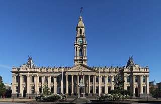
South Melbourne is an inner suburb in Melbourne, Victoria, Australia, 3 km south of Melbourne's Central Business District, located within the City of Port Phillip local government area. South Melbourne recorded a population of 11,548 at the 2021 census.

<span class="mw-page-title-main">Footscray, Victoria</span> Suburb of Melbourne, Victoria, Australia

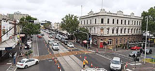
Footscray is an inner-city suburb in Melbourne, Victoria, Australia, 5 km (3.1 mi) west of Melbourne's Central Business District, located within the City of Maribyrnong local government area. Footscray recorded a population of 17,131 at the 2021 census.

<span class="mw-page-title-main">South Kensington railway station</span> Railway station in Melbourne, Australia

South Kensington railway station is located on the Werribee and Williamstown lines in Victoria, Australia. It serves the inner north-western Melbourne suburb of Kensington, and it opened on 11 March 1891.

The Sunbury railway line is a suburban electric railway in Melbourne, Australia. It has 15 stations, in Myki ticketing Zones 1 and 2. It is the electrified section of the Bendigo railway within metropolitan Melbourne. Prior to the line extension to Sunbury, the line was known as the Sydenham railway line, and prior to the extension of electrification to Sydenham, the line was known as the St Albans railway line.

<span class="mw-page-title-main">Flemington, Victoria</span> Suburb of Melbourne, Victoria, Australia

Flemington is an inner-city suburb in Melbourne, Victoria, Australia, 5 km (3.1 mi) north-west of Melbourne's Central Business District, located within the Cities of Melbourne and Moonee Valley local government areas. Flemington recorded a population of 7,025 at the 2021 census.

<span class="mw-page-title-main">Moonee Ponds Creek</span>

The Moonee Ponds Creek is a creek and major tributary of the Yarra River running through urban Melbourne, Victoria, Australia from northern to inner suburbs. In 2004 a reporter for The Age described it as "arguably the most abused tributary of the Yarra River, and part of the true underside of Melbourne".

<span class="mw-page-title-main">Kensington, Victoria</span> Suburb of Melbourne, Victoria, Australia

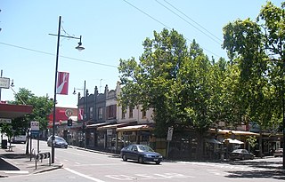
Kensington is an inner-city suburb in Melbourne, Victoria, Australia, 4 km (2.5 mi) north-west of Melbourne's Central Business District, located within the City of Melbourne local government area. Kensington recorded a population of 10,745 at the 2021 census.

<span class="mw-page-title-main">West Melbourne, Victoria</span> Suburb of Melbourne, Victoria, Australia

West Melbourne is an inner-city suburb in Melbourne, Victoria, Australia, 2 km (1.2 mi) north-west of the Melbourne central business district, located within the City of Melbourne local government area. West Melbourne recorded a population of 8,025 at the 2021 census.

<span class="mw-page-title-main">Francis Bourgeois</span> English painter

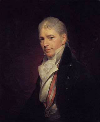
Sir Peter Francis Lewis Bourgeois RA was a landscape painter and history painter, and court painter to king George III of the United Kingdom.

Maria Bronislavovna Vorobyeva-Stebelska, also known as "Marie Vorobieff" or Marevna, was a 20th-century, Russian-born painter known for her work with Cubism and pointillism.

Hobsons Bay Coastal Trail

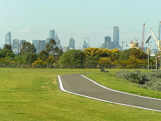
The Hobsons Bay Coastal Trail is a shared use path for cyclists and pedestrians, which follows the coast line of Hobsons Bay in the inner western suburbs in Melbourne, Victoria, Australia. The trail forms part of the western half of the Bayside Trail which encircles Port Phillip. It runs from the west side of the Westgate bridge, south and along the coast, finishing at the Skeleton Creek Trail in Sanctuary Lakes.

<span class="mw-page-title-main">Freight railways in Melbourne</span>

The rail network of Melbourne, Australia, has a significant number of railway lines and yards serving freight traffic. Rail transport in Victoria is heavily focused on Melbourne, and, as a consequence, much of the state's rail freight passes through the metropolitan network.

<span class="mw-page-title-main">Docklands Highway</span>

Docklands Highway is an urban highway stretching 12 kilometres from Brooklyn in Melbourne's inner western suburbs to the Docklands precinct, adjacent to the city. This name covers many consecutive streets and is not widely known to most drivers, as the entire allocation is still best known as by the names of its constituent parts: Francis Street, Whitehall Street, Moreland Street, Napier Street, Footscray Road, Dudley Street and Wurundjeri Way. This article will deal with the entire length of the corridor for sake of completion, as well to avoid confusion between declarations.

Henry Raeburn Dobson was a Scottish portrait and landscape painter from Edinburgh. He was active in Edinburgh and Brussels from 1918/1920 until 1980. His father, Henry John Dobson (1858–1928), and his brother, Cowan Dobson (1894–1980), were genre and portrait painters. Paintings of his are mainly painted in oil, whereas those of his landscapes are mainly painted in watercolours.

<span class="mw-page-title-main">Giles Firman Phillips</span> English painter

Giles Firmin Phillips (1780–1867) was an English artist and author. He painted landscapes and river scenes, primarily of the river Thames. His paintings were exhibited, among other venues, at the Royal Academy from 1836 - 1858. He is the author of several books on painting and lithography.

<span class="mw-page-title-main">Paul Albert Laurens</span> French painter (1870–1934)

Paul Albert Laurens was a French painter.

<span class="mw-page-title-main">West Melbourne Swamp</span>

The West Melbourne Swamp also known as Batman's Swamp, was a large saltwater wetland located to the west of the city of Melbourne, Victoria. It was an important resource for Aboriginal people.

Dudley Street is a main street in the Melbourne central business district, linking the northern Docklands district to the north-western corner of the Melbourne CBD. Dudley Street is possibly named after the Governor General from 1908 to 1911, the Second Earl of Dudley, William Humble Ward.

<span class="mw-page-title-main">Wurundjeri Way</span> Road in Melbourne, Victoria

Wurundjeri Way is a 1.9-kilometre (1.2 mi) road running through the Docklands Development west of the Melbourne central business district. It was constructed in 1999 as part of replanning and development of the former Melbourne rail yards and docks. Wurundjeri Way runs from Montague Street, South Melbourne to Dudley Street, West Melbourne via the Charles Grimes Bridge.

References

  1. John Lack, 'West Melbourne Swamp' eMelbourne encyclopedia
  2. 1 2 3 4 5 Gary Vines (1999) Dudley Flats Archaeological Investigation, www.academia.edu
  3. One of the "Dudley Mansions", The Unsuspected Slums West Melbourne, Culture Victoria.
  4. Barnett collection of Historic Photographs, Record 544, Housing and Construction Victoria Library. Department of Planning and Housing.
  5. "Drab Memories of Dudley Flats". The Argus . Melbourne: National Library of Australia. 15 July 1949. p. 2. Retrieved 25 February 2015.
  6. "DUDLEY FLATS DWELLERS". The Argus . Melbourne: National Library of Australia. 30 June 1938. p. 2. Retrieved 12 April 2013.
  7. 1 2 "This Life Suits Me": Dudley Flats to Docklands', Kasia Zygmuntowicz, Public Record Office Victoria, published in Ancestor December 2002.
  8. "DUDLEY FLATS AGAIN". The Argus . Melbourne: National Library of Australia. 1 March 1939. p. 4. Retrieved 13 April 2013.
  9. Newspaper clippings and Wood report in Melbourne City Council Archives, file 38/1894 on Dudley Flats.
  10. VPRS 5357 Land Selection and Correspondence Files, unit 4166, item 34, file G 57040 'West Melbourne – Dudley Flats'
  11. 'Shanty town at Dudley Flats', The Age, 16 March 1987
  12. Quarterly Fine Art Auction, Platinum House by Lawson~Menzies, February 13, 2013, Kensington, Australia
  13. A treasury of Australian art from the David Levine Collection. Adelaide, Rigby, 1981
  14. Selected works, Australian Art Sales Digest.
  15. Crossley, George S, Australian Art Auction Records
  16. Hunter, William Archived 22 February 2014 at the Wayback Machine , Australian Art Sales Digest
  17. Harding, Australian Art Sales Digest
  18. Barry Jones Interview Archived 1 December 2007 at the Wayback Machine , ABC Talking Heads, with PETER THOMPSON, screened: 26/06/2006
  19. Barry Jones Archived 24 December 2010 at the Wayback Machine , The National Interest, 6 August 2000.
  20. Humphries, Barry. "Return of a Passionate Pilgrim.", The Age, 7 October 2005.
  21. Sharon Thorne, Making Badlands, Transformations, No. 13, 2006.

Other sources