The Tibetan Plateau, also known as the Qinghai–Tibet Plateau or the Qing–Zang Plateau or as the Himalayan Plateau in India, is a vast elevated plateau located at the intersection of Central, South, and East Asia covering most of the Tibet Autonomous Region, most of Qinghai, western half of Sichuan, Southern Gansu provinces in Western China, southern Xinjiang, Bhutan, the Indian regions of Ladakh and Lahaul and Spiti as well as Gilgit-Baltistan in Pakistan, northwestern Nepal, eastern Tajikistan and southern Kyrgyzstan. It stretches approximately 1,000 kilometres (620 mi) north to south and 2,500 kilometres (1,600 mi) east to west. It is the world's highest and largest plateau above sea level, with an area of 2,500,000 square kilometres (970,000 sq mi). With an average elevation exceeding 4,500 metres (14,800 ft) and being surrounded by imposing mountain ranges that harbor the world's two highest summits, Mount Everest and K2, the Tibetan Plateau is often referred to as "the Roof of the World".

Lhünzhub County is a county in Lhasa towards the north-east of the main center of Chengguan, Tibet, China. It covers an area of 4,512 km2 (1,742 sq mi) and as of 2000 had a population of 50,895 people, almost all classified as rural. The southern portion, the Pengbo River Valley, contains fertile arable land, while the colder and more mountainous northern portion primarily supports grazing. The county has many monasteries, including the Reting Monastery.
Damxung is a county of Lhasa City, lying to the north of its main center of Chengguan, in the Tibet Autonomous Region, China. Its administrative seat is Damquka. The terrain is rugged, including the western Nyenchen Tanglha Mountains, with their highest peak rising to 7,111 metres (23,330 ft). As of 2013 the population was 40,000, with most of the people engaged in animal husbandry.

Nyêmo is a county in the Lhasa west of the main center of Chengguan, Tibet. It lies on the north bank of the Yarlung Tsangpo River, the northern part of the Brahmaputra. The county has an area of 3,276 square kilometres (1,265 sq mi), and as of 2011 had a population of 30,844 people, mostly engaged in agriculture or herding.

Qüxü County is a county in the Lhasa southwest of the main center of Chengguan, Tibet, China. It is mountainous in the northwest, flatter near the Lhasa River, which runs through the east of the county, and the Yarlung Tsangpo, which forms the southern border. The population as of 2000 was 29,690, mostly engaged in agriculture or animal husbandry. The county is home to the Nyethang Drolma Lhakhang Temple.

Doilungdêqên District is a district in Lhasa, north-west of the main center of Chengguan, Tibet Autonomous Region. It is largely agricultural or pastoral, but contains the western suburbs of the city of Lhasa. The Duilong River runs southeast through the district to the Lhasa River. A prehistoric site appears to be 3600–3000 years old. The district is home to the Tsurphu Monastery (1189) and the 17th century Nechung monastery.

Dagzê District is a district of Lhasa immediately east of the district of Chengguan, Tibet. The Lhasa River runs through the district. As of 2013 the total population was 29,152, mostly ethnic Tibetans engaged in agriculture. The district is home to the Ganden and Yerpa monasteries.

Maizhokunggar County or Meldro Gungkar County is a county of Lhasa and east of the main center of Chengguan, Tibet Autonomous Region. It has an area of 5,492 square kilometres (2,120 sq mi) with an average elevation of over 4,000 metres (13,000 ft). Most of the people are ethnic Tibetan and are engaged in agriculture or herding. Mining is a major source of tax revenue, but has created environmental problems. The county has various tourist attractions including hot springs and the Drigung Monastery.

Nagqu is a prefecture-level city in the north of the Chinese autonomous region of Tibet. On May 7, 2018, the former Nagqu Prefecture was officially declared the sixth prefecture-level city in Tibet after Lhasa, Shigatse, Chamdo, Nyingchi and Shannan. The regional area, covering an area of 450,537 km2 (173,953 sq mi), is bordered by Bayingolin and Hotan Prefectures of Xinjiang to the north, Haixi, Yushu Prefectures of Qinghai and Chamdo to the east, Nyingchi, Lhasa and Shigatse to the south, Ngari Prefecture to the west. As of the 2010 census, it had a population of 462,381. Since its official establishment in 2018, it is the largest prefecture-level city by area in the world, being slightly larger than Sweden and slightly less than twice the size of Victoria.

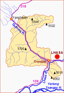
Yangbajain is a town approximately 87 kilometers (54 mi) north-west of Lhasa, halfway to Damxung in the Tibet Autonomous Region of China. The town lies just south of the Nyainqêntanglha Mountains, in an upland lush green valley surrounded by the tents of nomads with grazing yak and sheep populating the hillside. It is the site Yangpachen Monastery, which was historically the seat of the Shamarpas of Karma Kagyü and the Yangbajing International Cosmic Ray Observatory.

Xainza County, also Shantsa, Shentsa, is a county within Nagqu of the Tibet Autonomous Region of China. In 1999 the county had a population of 16,190.

The Lhasa River, also called Kyi Chu, is a northern tributary of the Yarlung Tsangpo River in the south of the Tibet Autonomous Region of China. The Yarlung Tsangpo is the upper section of the Brahmaputra River. The Lhasa River is subject to flooding with the summer monsoon rains, and structures have been built to control the floods. In its lower reaches the river valley is an important agricultural area. The city of Lhasa, named after the river, lies on the river. There are two large hydroelectric power stations on the river, the Zhikong Hydro Power Station (100 MW) and the Pangduo Hydro Power Station (160 MW)

Hutoushan Reservoir is a man made reservoir in Lhünzhub County, Tibet, to the north of the city of Lhasa. It is an important wintering place for black-necked cranes and other migratory birds.

Liuwu New Area or Niu New Area, officially Liuwu Subdistrict or Niu Subdistrict, is a subdivision of Doilungdêqên of Lhasa, Tibet in Western China. The Liuwu New Area is located southwest of downtown Chengguan, the old center of Lhasa.
The Pangduo Hydro Power Station is a reservoir and dam on the Lhasa River in Lhünzhub County to the east of Lhasa, Tibet Autonomous Region, China. The primary purposes are hydroelectric power generation and agricultural irrigation. Work started in 2008. The first turbine came into production in 2013 and the other three turbines in 2014. With annual generation capacity of 599 million kilowatt hours, it has been called the "Tibetan Three Gorges". Nevertheless, the comparison is hyperbole since the dam is only able to impound less than 1/30th that of Three Gorges.(31.9 vs 0.97 million acre-feet).
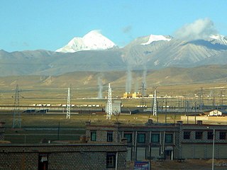
The Yangbajain Geothermal Field (羊八井地热田) is a geothermal field near the town of Yangbajain in Damxung County, Tibet Autonomous Region, China. The fluid is heated by magmatic activity not far below the surface. It is a tourist attraction and also supplies steam to a major power plant with 25 MW capacity.
The Yamdrok Hydropower Station, also known as the Yamdrok Yumtso or Yamzhog Yumcog hydropower station, is a hydroelectric power station just north of Yamdrok Lake, about 16 km (9.9 mi) southwest of Qüxü. The power station is in the Lhoka (Shannan) Prefecture of the Tibet Autonomous Region, China. Opposition to using the lake, considered holy, delayed construction at first. The project ran into difficulties and was two years late, completed in 1998.

The Nimu Maqu River is a left tributary of the Yarlung Tsangpo River that flows south through Nyêmo County in Lhasa Municipality, Tibet, China.
The Liuwu Bridge (Chinese: 柳吾大橋; pinyin: Liǔ wú dàqiáo} crosses the Lhasa River linking downtown Lhasa, Tibet to Lhasa railway station and Niu New Area on the south bank. It was built in conjunction with the Qinghai–Tibet Railway, which terminates on the south side of the river, and provides a connection to the town center on the north side.
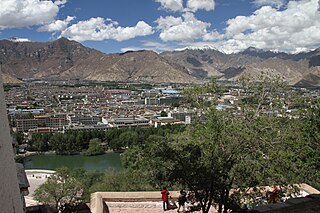
Lhasa is a prefecture-level city, one of the main administrative divisions of the Tibet Autonomous Region of China. It covers an area of 29,274 square kilometres (11,303 sq mi) of rugged and sparsely populated terrain. Its urban center is Lhasa, with around 300,000 residents, which mostly corresponds with the administrative Chengguan District, while its suburbs extend into Doilungdêqên District and Dagzê District. The consolidated prefecture-level city contains additional five, mostly rural, counties.