Duluth, Nebraska | |
|---|---|
 Duluth, Nebraska  Duluth, Nebraska | |
| Coordinates: 42°00′N101°36′W / 42°N 101.6°W | |
| Country | |
| State | |
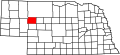
| County | Grant |
Duluth [1] is a former town of Grant County, Nebraska, United States, farm land now devoid of any buildings and existing only as a railroad locator-marker.